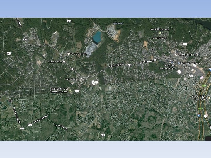
Mental Maps How does your mental map compare


 • Father of Geography – First to")


- Slides: 20
Mental Maps • How does your mental map compare to the street map? Consider differences in detail, distances, directions, etc. • What do the differences between the way you think of the Stafford area and the way it “actually” is on a street (cartographic) map imply?
Place vs. Space • Space: – The Geometric surface of the Earth • Place: – An area of bounded space that is important to you. • Examples of spaces? Examples of places?
History of Geography • The oldest existing map appears on a clay tablet made in Babylonia before 2000 B. C. • They developed the system of dividing a circle into 360 degrees. • Greek and Roman geographers measured (not always accurately) and devised a grid system of latitudes and longitudes • Ptolemy (2 nd c. CE) created first index of locations using grid 5
Ptolemy’s Map 6
The First Geographers Eratosthenes (273 -192 BC) • Father of Geography – First to use term • Geographica – Calculated circumference of the Earth • Produced map of “Known World” 7
8
Advances in Geography included: al Idrisi – Muslim geographic compiler – master of “known world” circa 1050 CE 9
Exploration - th 12 to th 18 c. • Portugal leads the early explorations – practical in nature • The astrolabe, caravel (ship) and compass assist mariners from Europe who must map what they find • In 1730, John Harrison discovered longitude. 10
Information can come from a variety of Geographic Sources GIS - Geographic Information Systems • This system collects information from a variety of sources and compiles it by computer into useful forms. 11
Information can come from a variety of Geographic Sources Satellite Images • Images taken from space have a variety of different uses: • Weather • Cartography • Defense 12
Aerial Photography & Remote Sensing 13
Key Concepts • Scale – truth is scale dependent, phenomena you study at one scale (e. g. local) may well be influenced by developments at other scales (e. g. regional, national, or global)
Comparing maps of different scale Different maps need to show different levels of detail. Sometimes you need to show a lot detail for a small area, and sometimes you need to show little detail of a larger area. A Small-Scale Map shows a large area with small details. A Large-Scale Map shows a small area with large details. It is good for relative locations It is good for detailed looks at 15 small areas
Map Scales • The smaller the right hand number the larger the scale of the map • 1: 75000 is a more detailed map than 1: 600000 which is a small scale map 16
Key Concepts • Site – The physical characteristics of a place • Situation – The place’s relationship with other places. 17
Site and Situation Constantinople - 1422 18
Key Concepts • Pattern – e. g. migration patterns, diffusion of cultures, languages, religions etc.
Key Concepts • Region – Areas formed by distinctive combinations of features; What do areas have in common? • Interconnections (Globalization) – Relationships of places and regions; How does one area relate to another?