Measuring Segregation in Boston Measures of segregation Racial

Measuring Segregation in Boston

Measures of segregation Racial segregation in Boston Income segregation in Boston Comparisons to other cities Potential solutions

Isolation index • Measure of isolation • Measured for one group • For an average group member, what percentage of their neighborhood is from their same group

Dissimilarity index • Measure of evenness • Measured between two groups • The percentage of one population that would have to move to produce perfect evenness

Racial segregation: relatively high, but going down
.")
Boston is becoming more Hispanic and Asian. Population by race and ethnicity. Boston (city). 1980 to 2010. Mixed 3% 6% Asian Hispanic Black White 5% 11% 9% 9% 18% 22% 23% 50% 47% 46% 2000 2016 8% 14% 22% 24% 68% 1980 59% 1990 Source: U. S. Census Bureau.
.")
Boston’s racial distribution has become more even. Dissimilarity Index. Race and ethnicity. Boston (city). 1980 to 2010. 1980 1990 2000 2010 78. 6 75. 3 70. 469. 2 75. 0 69. 4 67. 4 59. 0 54. 253. 354. 6 58. 3 43. 6 39. 9 34. 9 White-black 83. 0 White-Hispanic White-Asian 57. 6 55. 1 52. 8 52. 0 47. 3 43. 5 39. 6 Black-Hispanic 64. 5 Black-Asian Hispanic-Asian Sources: Decennial census. Brown S 4 project.

… And so has the metro area’s. Dissimilarity Index. Race and ethnicity. Boston MSA. 1980 to 2010. 1980 74. 6 68. 5 66. 0 61. 5 1990 2010 71. 7 62. 5 59. 6 59. 3 57. 2 62. 4 47. 8 45. 546. 0 43. 4 White-black 2000 White-Hispanic White-Asian 54. 3 49. 748. 4 45. 7 Black-Hispanic 57. 6 55. 0 Black-Asian 56. 7 53. 855. 3 49. 8 Hispanic-Asian Sources: Decennial census. Brown S 4 project.

All Bostonians are less isolated - except for Hispanic people. Isolation Index. Race and ethnicity. Boston (city). 1980 to 2010. 1980 1990 2000 2010 85. 5 78. 1 68. 8 65. 4 66. 1 61. 4 56. 5 50. 9 18. 2 White Sources: Decennial census. Brown S 4 project. Black 21. 4 25. 0 Hispanic 29. 3 24. 7 19. 9 18. 8 19. 2 Asian

And the metro’s Asian and Hispanic populations are increasingly isolated. Isolation index. Race and ethnicity. Boston MSA. 1980 to 2010. 1980 95. 0 91. 4 87. 0 1990 2000 2010 82. 5 50. 2 42. 2 36. 1 31. 2 27. 2 31. 1 21. 5 13. 5 White Black Sources: Decennial census. Calculations by Brown S 4 project. 10. 3 Hispanic 12. 9 Asian 15. 4

The odd relationship between diversity and segregation. Integration-Segregation Index. 100 most populous cities. 2010. Integration Score Diversity Score Source: Five. Thirty. Eight.

Boston ranks 70 th out of 100 cities in integrating its racial populations. Integration-Segregation Index. 100 most populous cities. 2010. City Diversity score Integration score Over/underperforming 1. Irvine, CA 60. 4% 58. 7% 11. 0% 2. Sacramento, CA 73. 8% 66. 5% 10. 1% 3. Paradise, NV 66. 5% 61. 6% 9. 8% 69. Toledo, OH 53. 3% 40. 0% -2. 8% 70. Boston, MA 68. 2% 50. 0% -2. 9% 71. Omaha, NE 49. 7% 37. 2% -3. 0% 98. Milwaukee, WI 66. 4% 38. 6% -13. 1% 99. Atlanta, GA 56. 8% 30. 7% -14. 5% 100. Chicago, IL 70. 3% 35. 7% -18. 6% Source: Five. Thirty. Eight. … …

Income segregation: relatively low, but going up

The lower income population in Boston is less ‘concentrated’ than in other large metro areas. Share of lower income households living in lower-income tracts. Ten largest MSAs. 2010. 41% New York 38% Philadelphia 37% Houston 37% Dallas 34% Los Angeles Source: Pew Research Center. Method from Massey and Fischer (2003). 32% Miami 31% Washington 29% 28% Chicago Boston 26% Atlanta

… The upper income population is also less ‘concentrated’ in Boston. Share of upper income households living in upper-income tracts. Ten largest MSAs. 2010. 24% 23% 17% 16% 15% 13% 12% 8% Houston Dallas Miami Los Angeles New York Source: Pew Research Center. Method from Massey and Fischer (2003). Atlanta Washington Philadelphia Chicago Boston

… And Boston has experienced less growth in income ‘concentration’ than other cities. Change in residential income segregation index (RISI). Ten largest MSAs. 1980 to 2010. 29% 21% 20% 11% 9% 6% 5% 4% 4% 0% Houston Dallas Miami Philadelphia New York Source: Pew Research Center. Method from Massey and Fischer (2003). Chicago Boston Los Angeles Washington Atlanta

Comparisons

The number of ‘hyper-segregated’ metro areas has dropped dramatically. Hyper-segregated metro areas. 1970 -2010. 287 52 21 All Metros Hyper-segregated, 1970 Source: Pew Research Center. Method from Massey and Fischer (2003). Hyper-segregated, 2010

The 52 hyper-segregated areas. Black-white hyper-segregated metro areas. 1970. All Hyper-Segregated Areas in 1970 Albany, GA Amarillo, TX Asheville, NC Atlanta, GA Buffalo, NY Cleveland, OH Denver, CO Fort Wayne, IN Grand Rapids, MI Houston, TX Indianapolis, IN Jacksonville, FL Lakeland, FL Las Vegas, NV Louisville, KY Sources: Massey and Tannen (2015). Muncie, IN Nashville, TN New Orleans, LA Oklahoma City, OK Omaha, NE-IA Pittsburgh, PA Richmond, VA Roanoke, VA Saginaw, MI Savannah, GA Springfield, MA Toledo, OH Washington, DC Wichita, KS York, PA Baltimore, MD Birmingham, AL Boston, MA Chattanooga, TN Chicago, IL Cleveland, OH Dayton, OH Detroit, MI Flint, MI Gadsden, AL Hartford, CT 2010 Kansas City, MO Milwaukee, MI Mobile, AL Monroe, LA New York, NY Philadelphia, PA Rochester, NY St. Louis, MO Syracuse, NY Winston-Salem, NC

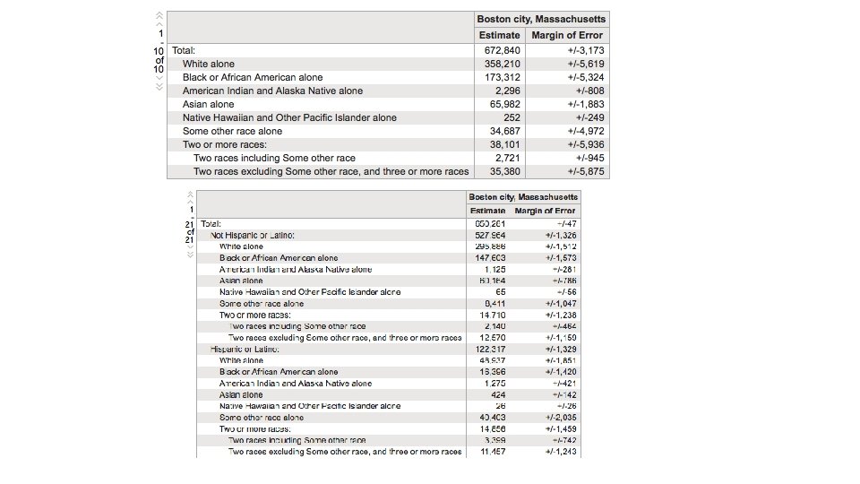
Some comparable cities by total population size and density. Population +/- 250, 000 of Boston. Density +/- 6, 000 people per square mile of Boston. 2016. City Total Population (rank Density, people per in brackets) square mile (rank in brackets) Race/ethnicity makeup White Black Asian Hispanic San Francisco 870, 887 (#13) 18, 569/sq mi (#2) 41% 5% 34% 15% Seattle 704, 358 (#18) 8, 405/sq mi (#29) 64% 7% 15% 6% Washington, DC 681, 170 (#21) 11, 148/sq mi (#17) 36% 4% 11% Boston 672, 840 (#22) 13, 938/sq mi (#7) 45% 23% 10% 19% Miami 453, 584 (#42) 12, 599/sq mi (#8) 12% 13% 1% 74% Source: American Community Survey, 1 year estimates.

Boston is doing okay in relation to comparable cities. Isolation Index. Race and ethnicity. 2010. White Black Hispanic Asian 82 77 65 73 64 63 53 51 46 29 25 25 19 19 29 19 18 8 9 3 Boston San Francisco Sources: Decennial census. Brown S 4 project. Washington DC Seattle Miami

Unevenness between the two largest groups in each comparison city. Dissimilarity Index. Two largest racial/ethnic groups. 2010. 72 69 40 Boston (White & Black) 77 San Francisco (White & Asian) Sources: Decennial census. Brown S 4 project. 38 Washington DC (Black & White) Seattle (White & Miami (Hispanic & Asian) Black)

Unevenness between black and white populations. Dissimilarity Index. Two largest racial/ethnic groups. 2010. 72 69 53 Boston 76 San Francisco Sources: Decennial census. Brown S 4 project. 52 Washington DC Seattle Miami

Northeastern cities by total population size and density. Population +/- 250, 000 of Boston. Density +/- 6, 000 people per square mile of Boston. 2016. City Total Population (rank Density, people per in brackets) square mile (rank in brackets) Race/ethnicity makeup White Black Asian Hispanic New York 8, 537, 673(#1) 28, 317/sq mi (#1) 32% 22% 14% 29% Philadelphia 1, 567, 872 (#6) 11, 683/sq mi (#14) 35% 41% 7% 14% Washington, DC 681, 170 (#21) 11, 148/sq mi (#17) 36% 4% 11% Boston 672, 840 (#22) 13, 938/sq mi (#7) 45% 23% 10% 19% Baltimore 614, 664 (#30) 7, 598/sq mi (#33) 27% 62% 2% 5% Source: American Community Survey, 1 year estimates.

Boston is doing okay in comparison to northeastern cities. Isolation Index. Race and ethnicity. 2010. White Black Hispanic Asian 83 77 73 65 66 62 63 58 58 51 48 33 29 19 37 17 18 14 8 Boston New York Sources: Decennial census. Brown S 4 project. Philadelphia Washington DC 10 Baltimore

Unevenness between the two largest groups in Northeastern cities. Dissimilarity Index. Two largest racial/ethnic groups. 2010. 73 72 69 69 66 Boston (White & New York (White & Philadelphia (White Washington DC Black) Hispanic & Black) (White & Black) Sources: Decennial census. Brown S 4 project. Baltimore (Black & White)

Unevenness between black and white populations in Northeastern cities. Dissimilarity Index. Two largest racial/ethnic groups. 2010. 81 73 72 69 Boston 69 New York Sources: Decennial census. Brown S 4 project. Philadelphia Washington DC Baltimore

Potential solutions

PARKING LOT

Some general ideas on undermining segregation Change school choice incentives • Alter district boundaries, school attendance formulas, public school funding Assist home-seekers in finding homes in neighborhoods with significant populations that are not of their race • Down-payment assistance, low-interest mortgages, public awareness campaign Strengthen services and amenities in minority neighborhoods • Improve public transit, social services, recreational facilities, business development Expand affordable housing options in exclusive neighborhoods and maintain affordability in low-income areas • Inclusionary zoning, affordable housing developments, public transit Enforce fair housing laws • Proactive testing of real estate agents, housing providers, and lending institutions Redraw municipal boundaries (or move toward regionalization) • Relevant to dense, multi-city metros like Boston/Cambridge/Newton/Brookline/Quincy/etc.

Spatial proximity index • Measure of clustering • Measured between two groups

Concentration index • Measure of concentration – how much space groups occupy • Measured between two groups

Absolute centralization index • Measure of centrality • Measured for one group

Entropy index • Measure of spatial distribution • Measured for all groups present

Five dimensions of A perfectly mixed situation segregation Uneven & clustered & concentrated & centralized & isolated

Other measures: Single proportions – e. g. percent of tracts that are 50% or more upper income Double proportions – e. g. percent of upper income households that live in neighborhoods that are 50% or more upper income Adjusted (and combined) standard measures – e. g. Five. Thirty. Eight’s Integration-Segregation Index, Rank Order Information Theory Index Renamed standard measures – e. g. Martin Prosperity Institute’s “Economic Segregation Index”, which is just the Dissimilarity Index applied to income

Local Income Segregation is Growing – and Growing Faster Than the Average Metro Area. Adjusted entropy index (rank-order information theory index). Boston MSA & mean of metro areas. 1970 to 2012. 0. 20 0. 15 0. 11 0. 10 0. 12 0. 10 0. 13 0. 16 Boston MSA 0. 10 1990 2000 0. 09 0. 11 Mean of metro areas 0. 05 0. 00 1970 Sources: Decennial census. Brown S 4 project. 1980 2012

… And So Are the Highest Earning 10% of Families. Adjusted entropy index (rank-order information theory index). Boston MSA & mean of metro areas. 1970 to 2012. 0. 25 0. 20 0. 15 0. 19 0. 17 Boston MSA 0. 17 0. 15 0. 14 1990 2000 0. 15 Mean of metro areas 0. 12 0. 10 0. 05 0. 20 0. 22 1970 Sources: Decennial census. Brown S 4 project. 1980 2012

The Lowest Earning 10% of Families Are Increasingly Segregated. Adjusted entropy index (rank-order information theory index). Boston MSA & mean of metro areas. 1970 to 2012. 0. 25 0. 19 0. 20 0. 16 0. 17 Boston MSA 0. 14 0. 15 0. 12 0. 10 0. 05 0. 10 1970 1980 Sources: Decennial census. Brown S 4 project. 1990 0. 14 0. 12 Mean of metro areas 2000 2012
- Slides: 40