Measuring Earthquakes Magnitude and Intensity How are Earthquakes


 • a 1, 000 km long fault that stretches from")


- Slides: 37
Measuring Earthquakes Magnitude and Intensity
How are Earthquakes Measured? • Magnitude is a measure of the amount of energy released at the source of the earthquake. Determined from measurements on seismographs. • Intensity measures the strength of shaking produced by the earthquake at a certain location. Describes how much people felt and the damage it caused. • .
• An earthquake can have many different intensity numbers, even though it has only one magnitude. • How can this be?
• An earthquake can have many different intensity numbers, even though it has only one magnitude. • Amount of damage depends on where earthquake occurs. • Eg. desert vs city
Richter Scale measures Magnitude • The Richter Scale is a standardized scale (from 1 -10) of earthquake magnitude. The higher the number, the stronger the earthquake. • It is based on the amplitude of the largest seismic wave recorded. • Accounts for the decrease in wave amplitude with increased distance. • Magnitudes less than 2. 0 are not felt by humans • When the Richter magnitude of an earthquake goes up by one unit, the amount of ground shaking caused by the earthquake goes up 10 times. • Eg. Magnitude 5. 0 is 10 times stronger than a Magnitude 4.
Charles Ritcher 1935 • Amount of damage depends on where earthquake occurs. • Eg. desert vs city
Measuring the size of earthquakes • Intensity scales • Modified Mercalli Intensity Scale was developed using California buildings as its standard • The drawback of intensity scales is that destruction may not be a true measure of the earthquakes actual severity – i. e. moderate earthquake causing severe damage in Armenia in 1988 because of poor building construction – also the 1985 earthquake in Mexico City caused massive damage because of the soft sediment under the city
What is the largest earthquake recorded? • 1960 Valdivia Earthquake occurred on May 22, 1960 near Valdivia, in southern Chile. • Assigned a magnitude of 9. 5 by the United States Geological Survey. • Referred to as the "Great Chilean Earthquake" or the "1960 Valdivia Earthquake.
Earthquake destruction • Amount of structural damage caused by earthquakes depends on: • Intensity and duration of the vibrations • Type of material building are one (sand vs rock) liquefaction • Design of the structure
Liquefaction • Liquefaction is a process by which watersaturated sediment temporarily loses strength and acts as a fluid (during an earthquake).
Damage caused by the 1964 Anchorage, Alaska earthquake
Liquefaction from the 1985 Mexico Earthquake
Homework • Complete and Turn in Earthquake WS
EXTRAS for next year…
Tsunamis, or seismic sea waves • Destructive waves that are often inappropriately called “tidal waves” • Result from vertical displacement along a fault located on the ocean floor or a large undersea landslide triggered by an earthquake. • In the open ocean height is usually less than 1 meter • In shallower coastal waters the water piles up to heights that occasionally exceed 30 meters • Can be very destructive
Formation of a tsunami
Tsunami Warning System
The Big One • “The Big One” is a hypothetical magnitude-9. 0 earthquake that could happen along the Cascadia Subduction Zone, a 1, 000 km fault line that runs from northern Vancouver Island to Northern California.
The Big One • The fault is a boundary between two tectonic plates: the Juan de Fuca tectonic plate and the North American plate (that we live on). • The Juan de Fuca plate is shoved beneath the North American plate. • But it’s become stuck for three centuries now, building up stress. When the rocks slip past each other along the fault, it will cause a “megathrust” earthquake.
Megathrust Earthquake
The Last Big One • The last destructive earthquake like this happened on Jan. 27, 1700, and experts say it is “inevitable” that another one will hit the coast.
Take Home Assignment • Read The Great Shaking and the Great Drowning and turn in the questions through Teams.
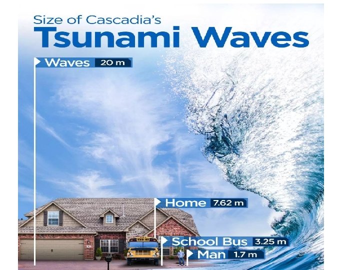
Cascadia Megathrust Earthquake • Seismologists estimate a 12% probability of a Cascadia Megathrust occurring in the next 50 years. • Estimate 10 000 deaths and 26 000 injuries. • Tofino would have a 20 min warning • 15 -20 m high waves
The Big One
Video • CBC: The big one is coming 2: 33 min http: //www. cbc. ca/player/play/2557297 694 • http: //www. cbc. ca/player/play/9533998 75854 • http: //www. cbc. ca/player/play/1616113 742 • 14 min
Will You Be Prepared? • Brainstorm: What do you need?
Assignment 2021 • Prepare an Earthquake Readiness Kit that fits into a shoe box • Include List of items in your kit • 1 page summary explaining why you need them • Plan for family if separated (discuss with family) • Where will you keep your kit? • Decorate your box
Science of Tsunamis • https: //www. youtube. com/watch? v=Wx 9 v. Pv-T 51 I
Earthquake Readiness Kit • https: //www. cdc. gov/disasters/earthqua kes/supplies. html
Earthquake Hazards 1. Ground shaking • The result of the waves set in motion by the earthquake • Some vibrations move up and down while others move side to side • Most buildings can withstand large up-anddown vibrations, but not side-to-side (cause collapse)
2. Liquifaction • Vibrations cause groundwater to rise, turning solid ground into a liquid-like material. • Buildings built on solid rock experience little damage; buildings located on bog muds or soft fill suffer severe damage
3. Tsunamis • Large ocean waves produced when earthquakes occur under water. • Caused by a large displacement in the water column
Tsunami’s • A tsunami is a large sea wave generated by an underwater earthquake, volcano, or landslide. • Eg. In 2004 Sumatra earthquake ruptured the sea floor, creating a tsunami
Cascadia Subduction Zone (CSZ) • a 1, 000 km long fault that stretches from Northern Vancouver Island to northern California. • It separates the Juan de Fuca and North America plates
Can earthquakes be predicted • Long-range forecasts • Give the probability of a certain magnitude earthquake occurring on a time scale of 30 to 100 years, or more – Using historical records or paleoseismology – Are important because they provide information used to » Develop the Uniform Building Code » Assist in land-use planning
Earthquake Probability between 1988 - 2018