Marine Provinces Continental Margins and Ocean Basins Continental

Marine Provinces: Continental Margins and Ocean Basins

Continental Margins and Ocean Basins • • Marine privinces Continental Margins – – • • • Active vs. Passive Turbidity Currents Deep Ocean Basins Hydrothermal Vents Sea Level Rise

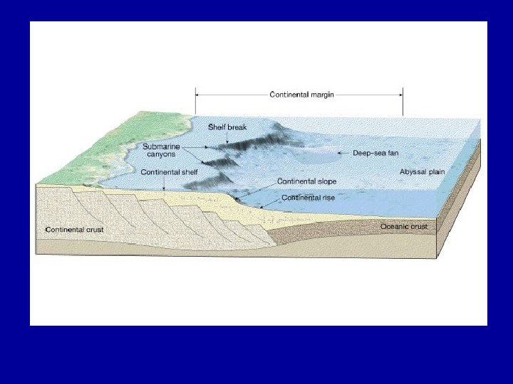
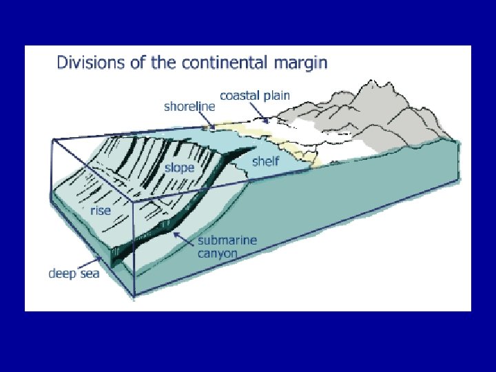
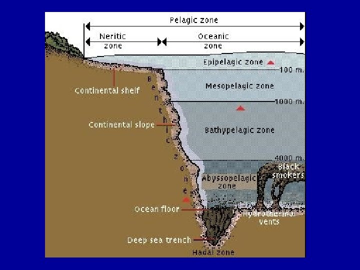
Ocean Provinces Three Major Provinces • Continental margins – Shallow-water areas close to shore • Deep-ocean basins – Deep-water areas farther from land • Mid-ocean ridge – Submarine mountain range


Continental Margins • Passive – Not close to any plate boundary – No major tectonic activity – East coast of United States • Active – Associated with convergent or transform plate boundaries – Much tectonic activity

Passive and Active Continental Margins

Continental Margins • Both active and passive margins have three divisions: – A shallow nearly flat continental shelf close to shore – A more steeply sloped continental slope to seaward – And the continental rise, an apron of sediment that blends the continental margins into the deep ocean basins • The continental shelf, slope, and rise together are called the continental margin.


Passive Margins • Continental margins facing the edges of diverging plates =Passive margins • little earthquake or volcanic activity • No collision or subduction taking place • Earth's weathering and erosional processes are dominant. • Lots of low-relief (flat) land extending both directions from the beach, long river systems, and relatively wide continental shelves. • Often occur along the Atlantic ocean they are also called Atlantic-type margins • Passive margins do not coincide with plate boundaries • The Eastern Seaboard, Gulf Coast.


Active Continental Margins

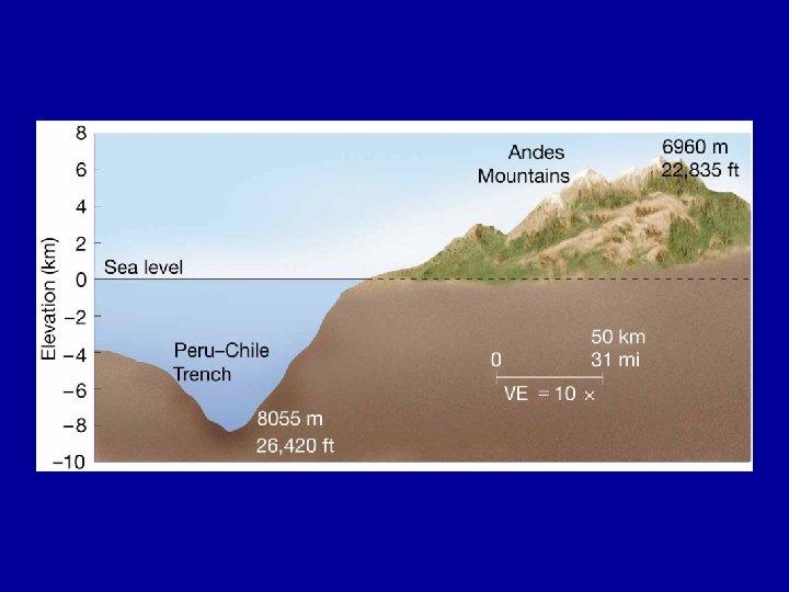
Active Margins • Near converging plates (or near places where plates are slipping past one another) = Active margins • Found on the leading edge of the continent where it is crashing into an oceanic plate. • Commonly the sites of tectonic activity: earthquakes, volcanoes, mountain building, and the formation of new igneous rock • Mountainous terrain, rivers are fairly short, and the continental shelf is narrow to non-existent, dropping off quickly into the depths of the subduction trench • Common in the Pacific and as such are also referred to as Pacific type margins • More varied topography than passive margins


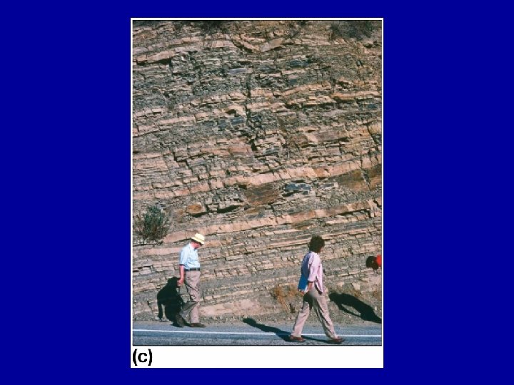
Continental Shelves • vary in width from almost zero up to the 1, 500 -km-wide (930 -mi) Siberian shelf in the Arctic Ocean. • The edge of the shelf occurs at a depth that ranges from 20 to 550 m (66 to 1, 800 ft) • consist of vast deposits of sands, muds, and gravels, overlying crystalline rocks or vast thicknesses of consolidated sedimentary rocks. • Changes in sea level have alternating exposed and inundated portions of the continental shelf. • nonglaciated shelves are usually exceptionally flat, with seaward slopes averaging on the order of 205 m per km (10 ft per mi), or less than 1° of slope. • regions of the oceans best known and the most exploited commercially. • virtually all of the petroleum, commercial sand gravel deposits, and fishery resources are found. It is also the locus of waste dumping • The edge of the shelf, called the shelf break, is marked by an abrupt increase in slope to an average of about 4°.


Continental Shelf


Continental Shelf Slopes

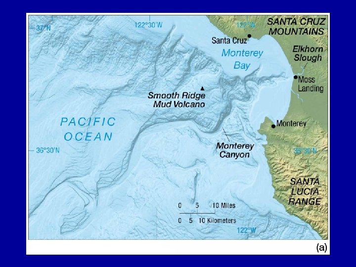
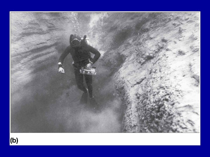
Continental Slope • begin at the shelf break and plunge downward to the great depths of the ocean basin • Deep submarine canyons, some comparable in size to the Grand Canyon of the Colorado River, are sometimes found cutting across the shelf and slope, often extending from the mouths of terrestrial rivers • submarine canyons on the continental shelf were initially carved during periods of lower sea level in the course of the ice ages. • Their continental slope extensions were carved and more recently modified by turbidity currents, subsea “landslides” of a dense slurry of water and sediment

Continental Slope

Continental Slope

Submarine Canyons

Turbidity Currents file: //pccshare/docs/rspresiado/My%20 Documents/PCC %20 Files/Courses/Oceanography/Geoscience_Animatio ns/Chapter_03/Turbidity_Currents_Graded_Bedding. html

Turbidity Currents
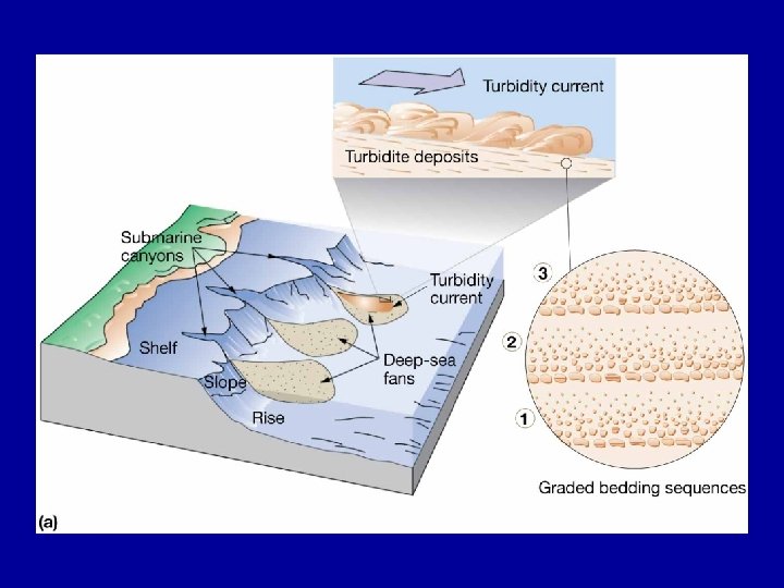

Continental Rise • Many continental slopes end in gently sloping, smooth-surfaced features called the continental rise • The continental rise usually has an inclination of less than 1/2°. • They have been found to consist of thick deposits of sediment, presumably deposited as a result of slumping and turbidity currents carrying sediment off the shelf and slope.

Continental Rise

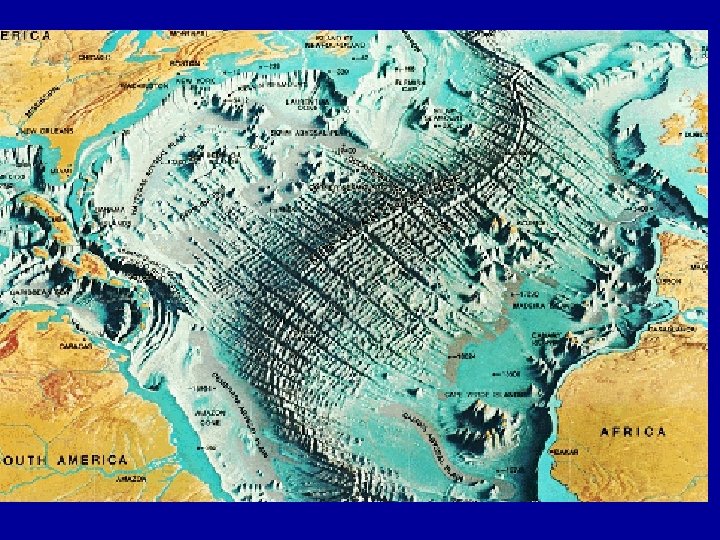
Deep Ocean Basins • Deep ocean basins are blanketed with sediments up to 5 km thick overlying basaltic rocks • Deep ocean basins comprise more than 50% of the Earth’s surface • Consists of rage systems and adjacent sediment covered plains • Flat expanses are interrupted by islands, hills, active and extinct volcanoes, and active zones of seafloor spreading

Deep Ocean Basins

Ocean Ridges • Ocean ridges are sources of new ocean floor • Youngest rock is at the active ridge center, and the rock becomes older with distance from the center • As the lithosphere cools, it shrinks and subsides • Ridges are often offset at regular intervals by transform faults, fractures in the lithosphere where shallow earthquakes are common

Snaked Appearance • This lack of alignment has to do with the rotation of the earth and the orientation of the pole of spreading -- because of rotational forces, the axis of spreading is never a straight line, but a curved line • Curving is less pronounced at the poles (less of a curve here) and more pronounced near the equator (more of a curve), so curve of spreading axis varies depending on latitude
 • White smokers")
Hydrothermal Vents • Warm water vents – temperatures below 30°C (86°F) • White smokers – temperatures from 30– 350°C (86– 662°F) • Black smokers – temperatures above 350°C (662°F)

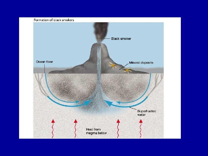
Hydrothermal Vents • fissures in the ocean floor that leak hot, acidic water • The size of the openings range from less than half an inch to more than six feet in diameter • The openings spew out jets of hot brine (up to 350°C) at velocities of up to five meters a second. • These brines are complex solutions containing lots of elements leached from the rock formations that they have transversed • As they are often black in color these vents are sometimes also referred to as 'Black Smokers'

How are they formed? • Vents are formed where the planets crustal plates are slowly spreading apart and magma is welling up from below to form mountain ranges known as mid ocean ridges. • Cold seawater percolates down through jointed and permeable rocks and descends to the lower reaches of the sheeted complexes, two to three miles deep. • The heated brines ascend and produce pervasive alteration (metamorphism) of the rocks with which they come in contact. • The heated brines then shoot out as jets (up to 350°C) and boiling is prevented by the high hydrostatic pressures of the overlying sea water.

In 1998 an expedition went to the North-Eastern Pacific to the previously discovered Mothra Hydrothermal Vent Field

Where are they Found?
.")
Vent crab with mussels and worm tubes (NOAA image).

Large vestimintiferan worms over six feet long are one of the most visible animals at the vents.

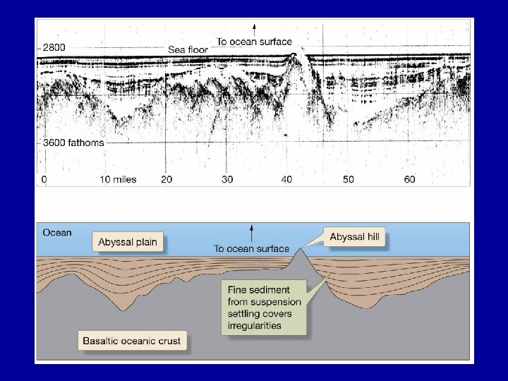
Abyssal Plains • Abyssal plains are flat, featureless expanses of sediment covered ocean floor, found on the periphery of all oceans • A quarter of Earth’s surface consists of abyssal plains and hills • They lie between continental marginal and ocean ridges at about 3, 700 to 5, 500 meters • The flatness is caused by a smoothing effect of layers of sediment often more that 1, 000 meters thick • The deep sediment may mask irregularities in the underlying ocean crust

Abyssal Hills • Small, sediment covered, extinct volcanoes or intrusions of once molten rock, usually less that 200 meters high • Features are associated with seafloor spreading
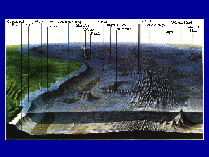

Trenches • Ocean trenches are long, narrow, steepsided depressions found on the ocean floor that contain the greatest depths in the ocean (11, 000 meters - western Pacific). • Generally, the trenches mark the transition between continents and ocean basins, especially in the Pacific basin.

Ocean Trenches

In Summary… • • Marine provinces Continental Margins – – • • • Active vs. Passive Turbidity Currents Deep Ocean Basins Hydrothermal Vents Sea Level Rise

55 Sea-Level Change and Climate Global average temperature changes during the past 18, 000 years 55

Sea-Level Change and Climate Cycles • During the last 1000 years Earth’s average temperature has varied by about 0. 5°C. • During the past 10, 000 years, it has varied within a range of about 2°C to 3°C. • In the preceding 2 - to 3 -million-year period, temperatures were as much as 10°C below what they are today. This was an ice age. • The last ice age may not be over and the relatively warm climate of the past 10, 000 years may simply represent an interglacial period. 56

57 Sea-Level Change and Climate Sea level rose about 1. 7 mm per year in the last century but is currently rising about 3 mm per year. It is expected to rise faster. It expected to rise 1 -2 meters or more by 2100. 57

Sea-Level Change and Climate Sea Level and the Greenhouse Effect • It is predicted that greenhouse warming of the planet will raise average temperatures by 2 o. C or more during the first half of this century. • Sea level is expected to rise faster perhaps by several meters or more within the next few decades. • A sea level rise of only a few tens of centimeters will inundate vast areas, including major coastal cities (e. g. , Miami, New York, New Orleans, Boston, Houston) and large areas of low lying land (e. g. Florida, Louisiana, Texas, Mississippi). Elsewhere, all current coastal structures will be adversely affected. • Estimated that a 1 m sea level rise will displace 131 million humans • 5 m rise would displace 410 million people 58

Sea-Level Change and Climate Eustatic Sea-Level Change • Ocean water warms and expands. • Polar ice sheets melt and transfer water from land to oceans. • Both of these cause the sea level to rise. Such changes of sea level are called eustatic changes and they occur rapidly and synchronously throughout the world. Isostatic Sea-Level Change • occur when a continent rises or falls due to cooling or heating or changes in ice mass loading—does not affect sea-level on other continents • can also occur if percentage of warm new oceanic crust on Earth surface changes, changing average elevation of seafloor and volume of oceans— occurs worldwide • takes place very slowly (thousands to millions of years) 59

Student Feedback • On a scrap piece of paper please answer the following two questions and deposit them as you exit: 1. What was the main point or points of lecture? 2. What topic was confusing or are you still unclear about?
- Slides: 60