Maps and Topography ES 2 D Main Idea


- Slides: 28
Maps and Topography
ES 2 D Main Idea: Any location on Earth can be pinpointed using longitude and latitude. Topographic maps are a 2 D representation of 3 D landforms and features.
Types of Maps • Flat map DISTORTION • Shows some _______ as you stretch the curved land mass to fit the flat surface. • Types of projections MERCATOR • _________ • Distorts as you move up in latitude AZIMUTHAL • _________ • Radial symmetry, greater circles CONICAL • __________ • Parallels are kept standard • 3 -D map or globe DISTORTION • Since the Earth is spherical is shows less ___________
Grid System LONGITUDE LATITUDE • Uses ___________ and ___________to locate specific points on the Earth DEGREES • This system is based on a number of _________ and DIRECTIONS ____________________ • The degrees are represented like hours, minutes, and seconds • Ex: 39° 47ˈˈ27ˈ means it is almost 40°
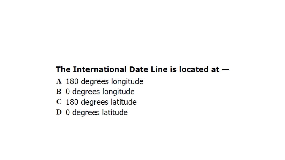
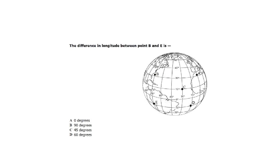
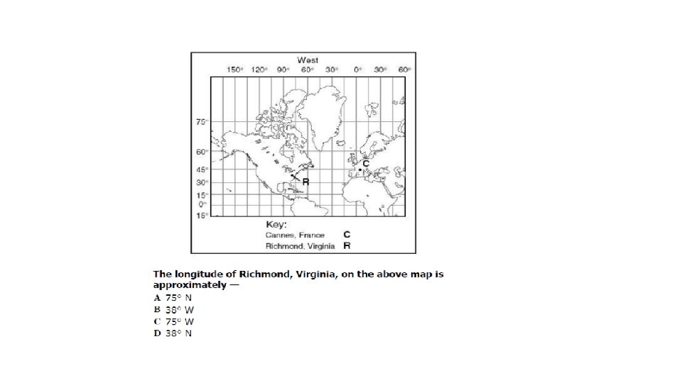
Longitude EAST SOUTH • Runs _______ to ______, but measures ______ to NORTH WEST PRIME MEREDIAN ________ of the _________________ (goes through England) WEST • Numbers go from 0 to 180 _____ and 0 to 180 EAST _________ INTERNATIONAL DATE LINE • The __________________ is located at 180 degrees longitude.
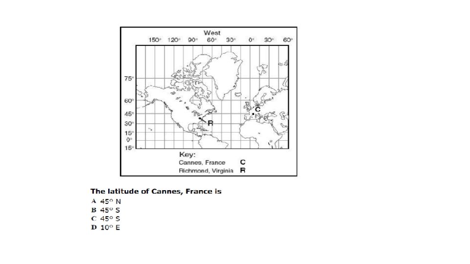
Latitude EAST WEST • Runs ________ to _______, but measures NORTH SOUTH ________ to _______ of the equator NORTH • Numbers go from 0 to 90 ______ and 0 to DISTORTION 90________
Note Break • Bahrain’s government banned Google Earth because it allowed Bahraini citizens to see vast tracts of royal-owned land their palaces next to poor and overcrowded Shi’ite villages • There is a nonexistent city in West Lancashire, England that shows up on Google Earth and Google Maps. This nonexistent towns is named Argleton in those maps. • A satellite archaeological researcher, Angela Micol, discovered some lost Egyptian pyramids using Google Earth
Topographic Maps 3 D • It is a 2 d model that provides information on _______ landforms SATELLITE • They are created by using _________ imagery LAYOUT • Shows the ________ of the land using colors, symbols, and contour lines.
Colors BLUE • ________ • water GREEN • ________ • vegetation PINK • ________ • Developed lands (city/towns) BLACK • ________ • roads BROWN • ________ • symbols
Symbols BUILDING • _______ CHURCH • _______ SCHOOL • _______ SWAMP • _______ RAILROAD • _______ BENCHMARK • X 157 ________ • Shows the exact elevation of a location DEPRESSION • ____________
Contour Lines ELEVATION • They connect points of equal __________ or height BROWN • They are __________ CROSS • They never _________ each other • Contours are curved on a map. When the lines are in a series of CIRCLE HILL circles, they represent a _______ or a __________ STEEPER • The closer the contour lines are the __________ the land GENTLE • If the lines are far apart the land is ___________
Contour Intervals CONSECUTIVE • The difference between two ____________ contour lines. • Take two line that are right next to each other and subtract. This tells you how much each line is worth.
Rule of V’s V • When contours cross water they form a _____ UPSTREAM • The V’s always point _______. So water flows in the opposite direction that the V’s are pointing DOWNHILL • Water will always flow __________
Map Scale DISTANCE • Shows the relationship between _______ on the map and DISTANCE __________ on the land • 1: 24000 • 1 inch (on the map)= 24000 inches (on land) • 1 foot (on the map)= 24000 feet (on land)
Pokémon Go Anyone Real World GPS Get in a group with someone who has Pokémon go. You have 10 minutes to collect as many Pokémon as possible. At the end of 10 minutes report back to class so that we can discuss GPS.
Note Break • If the satellites’ clocks don’t run ahead of ground clocks by 38 microseconds per day, GPS would not work. The reading received by the ground unit would be wrong after the satellite was in orbit only two minutes. This is called the General Relativistic Effect. • The satellites are spread out so that any point on Earth has at least six satellites in range at all times. Four are used to determine location, though three will do in a pinch, and the others are for confirmation of the location. • A GPS satellite is built to last for ten years is 17 feet across when the solar panels are extended, and weights around 2, 000 pounds. • A satellite signal takes 65 to 85 milliseconds to reach an earthbound receiver. • Geocaching is a sport invented to make use of the readily available GPS systems and a love of treasure hunting.