Maps and Map Skills Maps vs Globes Maps

Maps and Map Skills

Maps vs. Globes • Maps are important tools for geographers. • A globe is a better model of Earth than a map, but a globe has disadvantages that a map does not have. • What might be some of those disadvantages?

Maps vs. Globes • Pros and Cons of Globes: • Pros: highly accurate!!!, no distortion • Cons: difficult to use, lack of detail • Pros and Cons of Maps: • Pros: easy to use and read, produced at any scale, can be modified • Cons: distortions of shapes and sizes

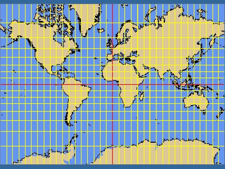
Latitude • The set of lines crossing the Earth’s surface horizontally, circling east and west. • Each line of latitude is always an equal distance from the next. • They are also known as parallels. All latitude lines are parallel to each other

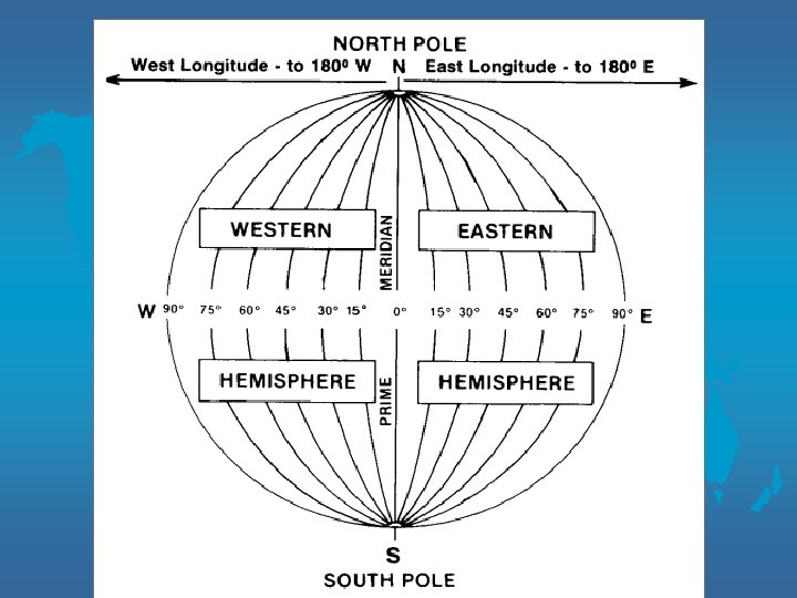
Longitude • A set of lines that run vertically along Earth’s surface from the North Pole to the South Pole • Lines are not parallel, converge at poles • Prime Meridian central line of longitude

Latitude and Longitude

Using Latitude & Longitude to Locate Places • Lines of latitude are numbered based on how far north or south they are from an imaginary line called the equator • This line circles the Earth exactly halfway between the NP and SP. 0 • The equator’s latitude degree is 0. There are 90 degrees between it and each of the poles. • Area between the equator and NP is “north” latitude 0 (22 N) • Area between the equator and SP is “south” latitude 0 (22 S)

• Lines of longitude are numbered based on how far east or west they are from another imaginary line. 0 • Prime Meridian’s longitude degree is 0. 0 0 • There are 180 of longitude east of the PM and 180 west of it. • Area east of the PM is known as “east” longitude. 0 (120 E) • Area west of the PM is known as “west” longitude. 0 (120 W)

Prime Meridian & International Date Line • The prime meridian does not circle the globe as the equator does. 0 • At 180 on the other side of the globe the meridian is called the international date line.

Global Grid • When lines of latitude and longitude cross, a grid is formed. • The grid is used to located certain places on earth

Geographic Mapping • Each line has an identifying number called degrees, or 0 parts of a circle. (41 ) • Degrees, can be further divided into minutes, or parts of a degree. There are 60 minutes, or parts of a degree. (10’) • Minutes can be divided into even smaller parts called seconds. There are 60 seconds in each minute. (10”) 0 • 41 10’ 10” Degrees 41 0 Minutes 10’ Seconds 10”
- Slides: 13