Maps and Map Skills Kinds of Maps General


- Slides: 24
Maps and Map Skills
Kinds of Maps • General Reference Maps • Provide the reader general information about an area or place. • Thematic Maps • Provide more specific information about an area or place than general reference maps.
General reference
Thematic Map
Reading Maps • Map Parts • Title • Legend or Key • Grid System • Direction • Scale • Map orientation – This has to do with direction
Compass Title Scale
Large Scale and Small Scale Maps • A large-scale map shows a small area such as a neighborhood street in great detail. • A small-scale map shows a large area such as a country or a continent in comparatively lesser detail. Small Area = Large Scale Large Area = Small Scale
Large Scale Small Area = Large Scale Large Area = Small Scale
Compass • Is used to orient a map toward north
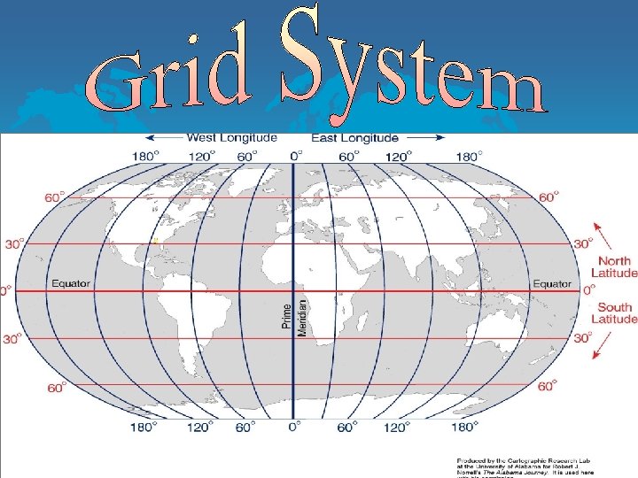
• Latitude • The set of lines crossing the Earth’s surface horizontally, Circling east and west. • Each line of latitude is always an equal distance from the next. • They are also known as parallels. All latitude lines are parallel to each other • Zero degree latitude is called the equator
• Longitude • A set of lines that run vertically along Earth’s surface from the North Pole to the South Pole • Zero degree longitude is called the Prime Meridian
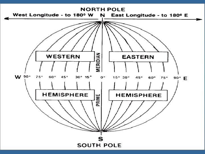
• Lines of longitude are numbered based on how far east or west they are from another imaginary line. • This line is called the Prime Meridian. 0 • Prime Meridian’s longitude degree is 0.
Prime Meridian & International Date Line • The prime meridian does not circle the globe as the equator does. • The PM runs from the NP to SP 0 • At 180 on the other side of the globe the meridian is called the international date line.
Global Grid • When lines of latitude and longitude cross a grid is formed. The grid is used to located certain places on earth
Using Latitude & Longitude to Locate Places • Lines of latitude are numbered based on how far north or south they are from an imaginary line called the equator • This line circles the Earth exactly halfway between the NP and SP. 0 • The equator’s latitude degree is 0. There are 90 degrees between it and each of the poles. • Area between the equator and NP is “north” latitude 0 (22 N) • Area between the equator and SP is “south” latitude 0 (22 S)
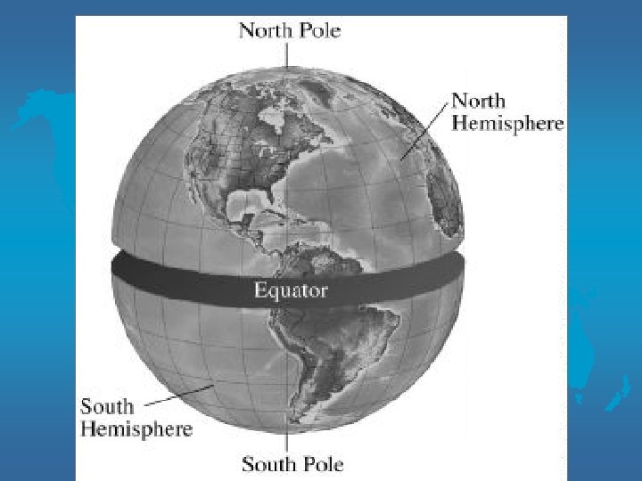
Hemispheres • The earth can be divided into halves. Each of these halves is called a hemisphere
Hemispheres at the Equator • The ½ north of the equator is called the northern hemisphere • The ½ south of the equator is called the southern hemisphere
Hemispheres at Prime Meridian and International Date Line • Earth can also be divided into hemispheres at the circle formed by the prime meridian and International date line • The ½ east of the prime meridian is called the eastern hemisphere. • The ½ west of the prime meridian is called the western hemisphere.
• Maps are important tools for geographers. • A globe is a better model of Earth than a map, but a globe has disadvantages that a map does not have
Problem of Distortion • Features are stretched to put Earth’s information onto a map.
Points to Remember • The projection one chooses to use depends on the information one wants. • All Maps are projections – they transfer Earth’s features from the globe to a flat surface (map). • When large areas of Earth are mapped, distortion is more serious. • When mapping small areas like cities, distortion is not usually evident.