Mapping Informal Settlements IAMP Definition of an Informal
")


 • Humanitarian Coordinating Agency (UNHCR)")

 District")


 ©Medair/Kate Holt")


 1 Collect Information while in the field • Cadaster •")
 Receive Referral Form Field Verification Send the PCode Keep a")


- Slides: 27
Mapping Informal Settlements (IAMP)
Definition of an Informal Settlement An Informal Settlement is – An unofficial group of temporary residential structures – Structure: plastic-sheeting and timber structures built for human habitation, with limited or no masonry – Size: Any number of tents, including single tents. – Area: Contiguous site of any size, or non-contiguous tents within 300 m 2 – Management: none or informal community-led management (Shawish or focal point) – Demographics: Not restricted to refugees or any particular ethnicity or nationality Inter Agency Mapping Platform
Benefits of the Project • NGOs can plan work in additional settlements, closing gaps, as basic information and location is provided • Regular detection of new settlements, inactivation of missing settlements • Same coding system allows for easier coordination on the national and local level as well as a common approach to reporting • One coherent and unified approach to mapping which creates a reliable baseline of data to build upon Inter Agency Mapping Platform
Purpose of IAMP Identify and collect basic Information on a regular Basis Common Language and data set Identify, track and locate vulnerable communities Serve as a common baseline for activities
History of the IAMP 2013 2014 May Partners used to collect data June as part of MEDAIR their work started with the pilot project August Started Mapping after cleanup January Mapping Project highlighted as best Practice 2015 2016 2017 January One sweep every 3 months Jan - Dec One sweep per month January IAMP project started in all of Lebanon Jan - Dec Monthly and Bimonthly sweeps Jan – Dec Bimonthly sweeps
IAMP Roles and Responsibilities • IAMP Coordinating Agency (Medair) • Humanitarian Coordinating Agency (UNHCR) • Mapping Partners (Medair, REACH, Soliarites International, CISP, PU-AMI Beirut/Mt. Lebanon, and PU-AMI South Inter Agency Mapping Platform
Field Level Impacts • The Public Viewer account on Collector has enabled field teams to locate settlements and plan more efficient distributions • Database of key contacts for the refugee communities and focal points to base interventions upon • The PCode system allows for the combining of multiple data sets together for gap analysis comparisons • Community self-identification during emergencies and in everyday interactions with the humanitarian community Inter Agency Mapping Platform
Coding System: PCodes 5 3 2 1 1 – 001 Governorate (ie: Bekaa) District (ie: Baalbek) Cadastral Shelter Type Incremental Number inside each Cadaster 01: Informal Settlement (ie: Ras Baalbek Es-Sahel) The new PCode will be defined as “ 12345_01_001” -The first 5 digits indicate the CAS-Code. The number is unique for every cadastral in Lebanon. -The second 2 digits indicate the type of the settlement -The last 3 digits indicate the sequential number of the Informal Settlement (within every cadastral). Inter Agency Mapping Platform
Mapping Partners for 2017 Mapping Partners are: • Solidarités International • PU-AMI, Beirut/Mt. Lebanon • PU-AMI, Jezzine/Saida • CISP • Medair Inter Agency Mapping Platform
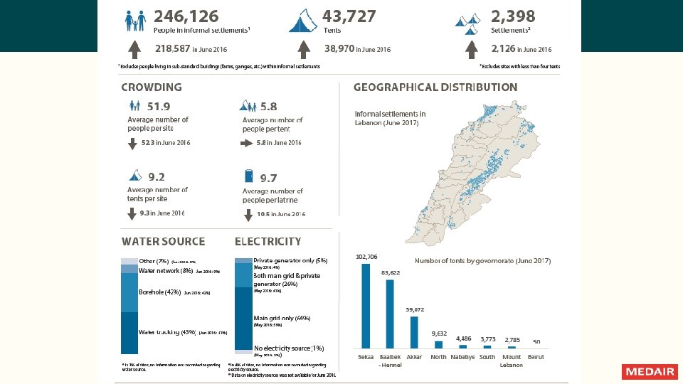
IAMP Update • Nationally 23. 26% of Registered Syrian Changes between IAMP 24 and IAMP 34 13. 61% Increase in Number of Settlements. Population lives in Informal Settlements* – 65. 77% in the Bekaa – 26. 36% in the North – 5. 08% in the South – 2. 79% in Beirut/Mt. Lebanon • 236, 662 Individuals 19. 71% Increase in Number of Tents. . 19. 1% Increase in Number of Individuals. . • 41, 613 Tents • 4, 373 Settlements *Based off number of registered Syrian population as of 30 Sep 2016 and IAMP 34 Inter Agency Mapping Platform
IAMP Coordinating Agency Responsibilities • Training Mapping Partners • Cleaning and verifying the data received nationally Communication • Regular feedback to mapping partners on data collected • Collating data and issuing to UNHCR once a month • Periodic review of dataset after IAMP release to communicate issues – to Mapping Partners and FPs • Sole responsibility to create PCodes for each Informal Settlement • Regular communication/advocacy with national level working groups on updated status of the IAMP • Facilitating access to and managing the online web maps • Ad-hoc updates on IAMP data collection nationally for IAMP Key Contacts • Lead collation of best practices and lessons learned for the improvement of methodology • Forwarding as appropriate issues faced in the field, referrals, and other matters related to the IAMP
Humanitarian Coordinating Agency Responsibilities Communication • Promotion of the IAMP as a core data set and tool for coordination in informal settlements • Dissemination of the IAMP dataset to all relevant parties • Hosting and retaining ownership of the data • Dissemination of the restricted access IAMP data as needed • Releasing the IAMP dataset on a monthly basis • Designating an IAMP focal point at each UNHCR field- or sub-office for purposes of monitoring implementation of IAMP methodology and promotion of the IAMP at the local level • Collate all existing information on Informal Settlements as part of the initial set-up process for mapping in a new area • Facilitating access to politically difficult areas and helping address problems in the field • Regular communication with the IAMP Coordinating Agency on overall progress, bottlenecks, changes to the methodology and other issues • Ensuring connection between various sector WGs and the IAMP at national and local level
Mapping Partner Responsibilities • Collecting data according to the methodology • Reporting challenges to the IAMP Coordinating Agency • Ensuring Pcode Business Cards are available in every settlement • Attending trainings as organized by IAMP Coordinating Agency • Active participation in any meetings related to further development of the project • Advocating for the identification and use of IAMP PCodes in their area of operation Communication • Daily (or as data is collected) communication with the IAMP Coordinating Agency – data collection sheets, issues, sweep progress • Promotion of IAMP in local WGs and mapping implementation in their area of coverage • Communication of best practices, bottlenecks, issues in the field and proposed changes • Communicating with partners regarding any sites missing pcodes
Arc. GIS Online ©Medair/Kate Holt Inter Agency Mapping Platform
Collector (Public Viewer Account) ©Medair/Kate Holt
Important • When mapping teams are conducting mapping, they should be doing this independently from other projects –This is to ensure active and impartial identification of new settlements, regardless of the agency’s coverage of those settlements Inter Agency Mapping Platform
Field Operation Procedures 1. Arrive to the site 2. Identify the focal point /Shawish, and introduce the staff and the project. – – Identify the Shawish or Community Focal Point Introduce the staff and project: explaining why the staff is there and also ask permission to conduct the assessment Inter Agency Mapping Platform
Pcode Visibility Creating or Checking PCode Visibility – In second visit the PCode Card / Shawish business Card should be given to the Shawish that contains the Pcode, the FP and the FP’s Phone number among other data. – On every visit, check that the PCode Card is available and correct, if not issue a new one. Inter Agency Mapping Platform
Counting Tents or Closed/Empty Tents • All tents regardless of its occupancy status – If a tent is empty but liveable, count it as a tent – Mention the number of empty tents in the notes as empty tents can influence the ratio of individuals to tents and can make the results appear strange – Do not count tents if they are a Mosque, kitchen, shop or anything else that in not intended to be a dwelling • If tents are empty (and door closed up) – Ask a nearby neighbour regarding the tent – If no one is available to ask about the closed tent, leave the site to sweep on another day. – If no one is available on the second attempt to sweep the site, write down the number of empty tents and any directly observable information and make a note “after a second sweep attempt, no one was found on the site. ” In this case the size would still be considered Active/Less than 4 not Inactive. Inter Agency Mapping Platform
Areas with Restricted Access • Alternative Mapping Procedure in the South – Due to restrains in using all mobile devices, CISP is using Google earth to assign longitude and latitude • Restricted access due to security constraints – Alternative means of collecting data in areas with limited access • Issues of ensuring data quality • Mapping partner versus temporary and limited secondment • Long-term affect on resource advocacy Inter Agency Mapping Platform
Data Validation Procedure • Flow chart of processes. Inter Agency Mapping Platform
Referral Procedure (Implementing Partners) 1 Collect Information while in the field • Cadaster • Coordinates • Nbr of tents • FP name and phone • Nearest Pcoded site • Distinguishing features near by 2 Download the referral form • Find it on the UNHCR IM Drop. Box under Mapping and PCodes 3 Email it to the correct people • Local Implementing Partner • IAMP Coordinating Agency • Relevant shelter and WASH Sector FP
Referral Procedure (Mapping Partner) Receive Referral Form Field Verification Send the PCode Keep a Record
IAMP Sample
Any Questions? Inter Agency Mapping Platform
Thank You Inter Agency Mapping Platform