MAPPING GEOPHYSICAL HAZARDS AND RISKS IN THE PHILIPPINES


 UNDP Education Health Income")
")
 Hazards/Risks 8 July 1991 (Cabrido, Boy, PDI, INS) 27")
")
 Surigao Del Sur La Union Benguet Pangasinan Pampanga Tarlac Ifugao Davao Oriental")

 Ifugao Lanao Del Sur Sarangani Benguet Mountain Province Bukidnon Aurora Davao")

 Camiguin Sulu Biliran Albay Bataan Sorsogon South Cotabato Laguna Camarines Sur Batanes")

 Sulu Tawi-tawi Basilan Batanes Guimaras Romblon Siquijor Surigao Del Norte Camiguin Masbate")

- Slides: 21
MAPPING GEOPHYSICAL HAZARDS AND RISKS IN THE PHILIPPINES Dissemination Workshop for Mapping Philippine Vulnerability to Environmental Disasters Klima Climate Change Center 8 July 2005 Solid Earth Dynamics Program -Center for Environmental Geomatics Manila Observatory
Outline I. Introduction II. Geophysical Hazards and Risk Mapping III. Conclusion
Seismicity of the Philippines from 1907 -2000 Source: Phivolcs Database
RISK likelihood of harm, loss, disaster
Physical impact of disturbance HAZARD Elements affected by hazard EXPOSURE Capacity of a community to prepare, absorb and recover from hazard VULNERABILITY RISK
Risk = H x E x V
EXPOSURE POPULATION DENSITY 2000 National Statistics Office City/Municipal Population Data 1 km x 1 km grids
VULNERABILITY HUMAN DEVELOPMENT INDEX (2000) UNDP Education Health Income
EXPOSURE/VULNERABILITY POPULATION DENSITY 2000 HUMAN DEVELOPMENT INDEX (2000)
19 July 1990 (PDI, INS) Hazards/Risks 8 July 1991 (Cabrido, Boy, PDI, INS) 27 July 1990 (Gacad, Romeo, AFP, INS)
HAZARD EARTHQUAKE National Geophysical Data Center 0. 25º x 0. 25º grids (1963 -1996)
RISK (Earthquake) Surigao Del Sur La Union Benguet Pangasinan Pampanga Tarlac Ifugao Davao Oriental Nueva Vizcaya Nueva Ecija Agusan Del Surigao Del Norte Sarangani Zambales Maguindanao Bataan Batangas Agusan Del Norte Davao del Norte Ilocos Sur
HAZARD EARTHQUAKE-INDUCED SHALLOW LANDSLIDES PHIVOLCS
RISK (EQ-Induced Landslides) Ifugao Lanao Del Sur Sarangani Benguet Mountain Province Bukidnon Aurora Davao Del Sur Davao Oriental Rizal Misamis Oriental Abra Nueva Vizcaya Quirino Davao del Norte Kalinga Apayao South Cotabato Zambales Southern Leyte
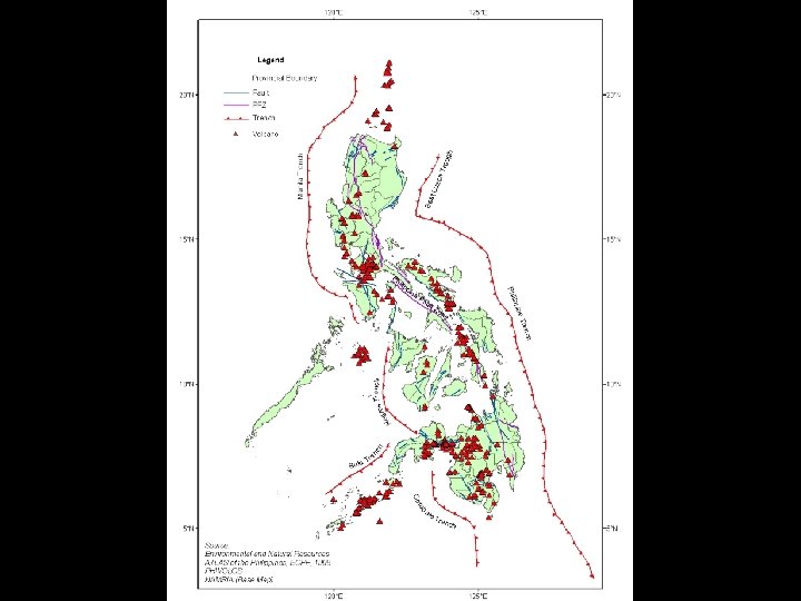
HAZARD DISTRIBUTION OF VOLCANOES PHIVOLCS
RISK (Volcano) Camiguin Sulu Biliran Albay Bataan Sorsogon South Cotabato Laguna Camarines Sur Batanes Negros Occidental Marinduque North Cotabato Batangas Zambales Pampanga Bukidnon Lanao Del Sur Negros Oriental Quezon
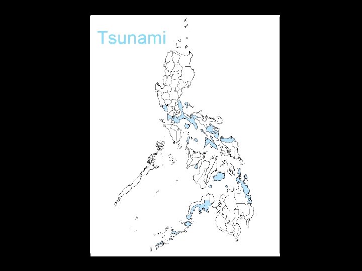
HAZARD TSUNAMI Environmental and Natural Resources Atlas of the Philippines, ECPF
RISK (Tsunami) Sulu Tawi-tawi Basilan Batanes Guimaras Romblon Siquijor Surigao Del Norte Camiguin Masbate Zamboanga Del Sur Bataan Batangas Quezon Bohol Sorsogon Northern Samar Albay Marinduque Surigao Del Sur
Conclusion • Areas at risk to earthquakes - West of Northern Luzon and Eastern Mindanao • Areas at risk to earthquake-induced landslides - Northern Luzon and Mindanao • Areas at risk to tsunamis - Northwest to southeast diagonal across RP • Areas at risk to volcanoes - Northwest to southeast diagonal across RP