MAP READING SKILLS WHAT IS A TOPOGRAPHICAL MAP


 from (X) For bearings from less than 180")
 from (X) For bearings more than 180 °")


- Slides: 52
MAP READING SKILLS
WHAT IS A TOPOGRAPHICAL MAP? n n A topographical map is a map that shows human and natural / physical features to scale on the Earth’s surface. It also shows that the location of human features or settlements is influenced by the nature of the physical landscape.
46 38 Elements of a topographical Title map PULAU UBIN 39 40 41 42 43 44 45 46 47 46 N 45 45 44 44 43 43 42 42 47 38 39 Grid lines 40 41 Contours 42 43 44 Names of places 45 46 North arrow
Identify and label the elements of a topographical map Find the 4 fig grid ref of the quarry and Ladang Koyan Find the 6 fig grid ref of X and the mosque
title grid lines contour lines scales
map symbols legend or key
GRID REFERENCES Vertical lines on topo maps are called eastings n Horizontal lines are called northings n Together they are called grid lines n They help to find locations on a map n
northings eastings 24 23 grid squares 22 21 31 32 33 34
GRID REFERENCES The four – figure grid reference is used to find a location on a grid square n The six – figure grid reference is used for more accurate location n
55 northings 54 34 eastings 35
FOUR FIGURE GRID REFERENCE 55 54 34 35
FOUR FIGURE GRID REFERENCE 55 3355 54 34 35
SIX FIGURE GRID REFERENCE 55 northings 54 34 eastings 35
Six-figure grid reference 55 9 8 7 6 5 4 3 1 34 2 3 4 5 6 7 eastings 8 2 1 54 9 35 northings
Six-figure grid reference 55 9 8 7 6 5 4 3 2 1 54 34 1 2 3 4 5 6 7 eastings 8 9 35 northings
Six-figure grid reference 55 9 8 343 547 x 7 6 5 4 northings eastings 3 1 34 2 3 4 5 6 7 8 2 1 54 9 35
Six-figure grid reference 55 9 8 7 6 5 northings 4 34 4 54 4 Z 3 1 34 2 3 4 5 eastings 6 7 8 2 1 9 54 35
REMEMBER: Always read the eastings first then the northings
SCALES
SCALES Scales are used to show distance on a map n Can be represented in many ways n Use line scale and representative fraction in topo maps n
What is wrong with this map? There is no scale. Cannot indicate distance. How big is this area?
Type of scale Representative fraction
Type of scale Line scale
Measuring distance by a representative fraction Tracing the route with a piece Measuring straight of string distance with a ruler 1: 50 000
MEASUREMENT Use a string to align between the 2 points n Mark the points n Use a ruler to measure in cm n Multiply by the scale given in the map n Divide by 100 000 to get the answer in km n
DIRECTIONS
COMPASS DIRECTIONS NNW NNE NORTH WEST NORTH EAST WNW ENE WEST EAST ESE WSW SOUTH EAST SOUTH WEST SSW SOUTH SSE
Using compass directions Give directions to the boatman to steer his way out of the jetty to reach the island.
What problem do you think can happen if we use this method of giving directions? n Lacks accuracy
COMPASS BEARINGS 0° 360 ° NNW NNE 315 ° NORTH EAST NORTH WEST WNW 270 ° 45 ° ENE EAST WEST 90 ° ESE WSW SOUTH EAST SOUTH WEST 135 ° 225 ° SSW SSE SOUTH 180 °
What is the direction of the mosque from Saujana Hill? southeast N
What is the direction of the school from Saujana Hill? southeast N
What is the direction of the dam from Upper Mandai II? Northeast North
North Southeast What is the direction of the school from the pier?
What is the bearing of the school from Upper Mandai II?
What is the bearing of Upper Mandai II from the school?
To find the bearings of (Y) from (X) For bearings from less than 180 ° Draw the North line that is parallel to the eastings on the map From X Read bearings in the clockwise direction Y 0° Draw a line to join X and Y X 90° Align protractor along the North Line with 0° corresponding to North 180°
To find the bearings of (Y) from (X) For bearings more than 180 ° Draw the North line that is parallel to the eastings on the map From X Read bearings in the anti-clockwise direction, then subtract from 360° 0° Y Draw a line to join X and Y X 90° Align protractor along the North Line with 0° corresponding to North 180°
N
Find the bearings of the mosque from Saujana Hill? 0° 106° N
Find the bearings of the factory from the mosque? 0° 77° N
Find the bearings of the mosque from the factory? 0° 360° - 106° = 254° 74° N 180° + 74° = 254° 180°
Find the bearings of Saujana Hill from the mosque? 360° - 72° = 288° 180° + 108° = 288° N
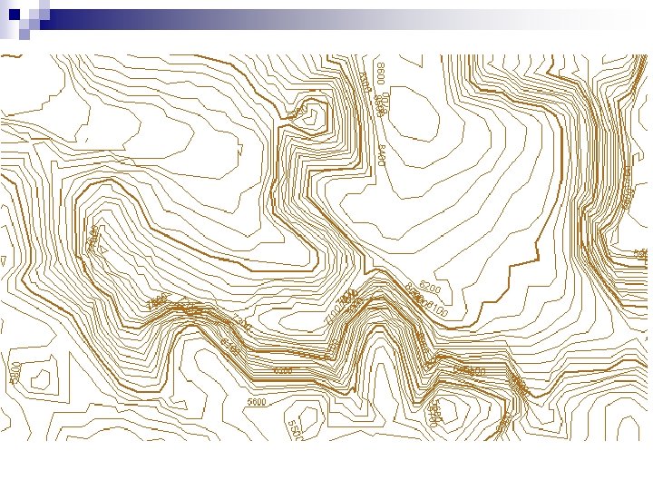
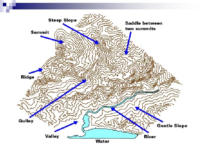
RELIEF & CONTOUR LINES
How to show this landform on a topographical map?
Relief Shape of the land n Shown on a topo map using point symbols and contours n Point symbols are used to show specific heights n Contour lines are also used to show height or elevation n
Contour Lines n lines joining places of similar height above sea level
contour lines
Contour interval - The difference in height 20 mbetween two contour lines 30 m 40 m Contour interval is 10 m
Contour interval 20 m 40 m 60 m Contour interval is 20 m