Map of Tunisia Surrounding countries Algeria Libya Capital

Map of Tunisia Surrounding countries • Algeria • Libya Capital • Tunis

Major Cities 5 Major Cities • Tunis • Gabes • Gafsa • Monastir • Kelibia

Geography Landforms • Mt. Jebel Chambi • Tunisian Dorsale • Jebel Dahar • Grand Erg Oriental

Historical sites Roman archaeological site in Carthage Great Mosque of Kairouan

Outdoor Activities

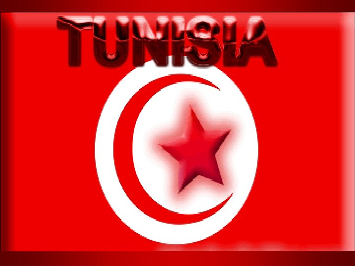
Flag Red is a traditional color of Islam and was the color adopted by the Ottoman Empire who ruled Tunisia from late 16 th century until 1881. It also came to represent resistance against Turkish supremacy. The crescent and star are traditional symbols of Islam and are also considered to be lucky symbols.

SettingLocation Tunisia is located in between Libya and Algeria also is bordered by the Mediterranean sea to the north. Tunisia is mostly desert.

Transportation

Arts and Culture Bardo Museum in Carthage National Museum

Natural Hazards Dust Storms Floods

Life Expectancy male: 73 years female: 77. 17 years Top 3 Imports textiles, machinery and equipment, hydrocarbons Top 3 Exports clothing, semi-finished goods and textiles, agricultural products Major Religion • Muslim 98% • Christian 1% • Jewish and other 1% Largest Ethnic Group • Arab 98% • European 1% • Jewish and other 1%

Climate and Weather Conditions Spring is pleasant everywhere in Tunisia, even if it may rain in the North. Sahara is less blistering but nights are chilly. In summertime, sea wind attenuates heat on the coasts. Inside the country and in the south, temperatures are very high. Autumn is pleasant but rains begin in November. The most commonly spoken languages in Tunisia. Arabic is the official language of Tunisia Arabic, Jerba, French are other languages spoken

Top 3 Languages • Arabic • Italian • German

Lablabi Food thick soup made with chickpeas and garlic
- Slides: 15