Managed Aquifer Recharge MAR in Baluchistan Pakistan Present
 in Baluchistan, Pakistan, Present Situation and Future Prospects © Authors.")
Managed Aquifer Recharge (MAR) in Baluchistan, Pakistan, Present Situation and Future Prospects © Authors. All rights reserved Sikandar Hayat, Hana Ben Mahrez, Zsóka Szabó, Ádám Tóth, and Judit Mádl-Szőnyi
 techniques in Baluchistan")
Goals • To revise the development of managed aquifer recharge (MAR) techniques in Baluchistan (Pakistan) • MAR suitability mapping for Quetta Valley to delineate suitable sites for MAR implementation using GIS multi-criteria decision analysis and online INOWAS platform • This study will provide us a preliminary map to design a suitable groundwater management plan for Quetta Valley to reduce ground water depletion and related problems.
 while the Quetta Valley (where the MAR suitability mapping")
Map of Baluchistan province (Pakistan) while the Quetta Valley (where the MAR suitability mapping is conducted in the present study) is shown in green.

Review of MAR in Baluchistan • Baluchistan is the largest province of Pakistan by area with hyper-arid to dry climate • Groundwater is the only reliable source of freshwater in Baluchistan • Rapid growth in population, industrialization, migration from Afghanistan, scarce rainfall and expansion of agriculture resulted in rapid decline in water table • 11 out of 18 basins in Baluchistan are suffering from groundwater depletion (2 -3 m/year cumulative decline in water table) (M. Ashraf, Ashfaq A. , 2017) Increasing trend of tube wells in Quetta (M. Ashraf, Ashfaq A. , 2017)

Review of MAR in Baluchistan MAR is successfully implemented in Baluchistan. Following MAR techniques were applied: (M. Ashraf, Ashfaq A. , 2017) 1 - Leaky Dams to clean the stream water of fine sediments by slowing its velocity (Success)

Review of MAR in Baluchistan 2 - Ditches, Furrows to reduce flow velocity and increase filtration, low cost, simple. (Success) 3 -Watershed Management to control the soil erosion by water and wind, xerophytic plants were planted (Success)
 because of a) clogging")
Review of MAR in Baluchistan 4 -Delay Action Dams (Failed) because of a) clogging caused by flash floods over barren land which brings huge amount of sediments in the reservoir b) High evaporation rate Silt deposited in delay action dam

Review of MAR in Baluchistan 5 -Terraces to slow down the surface flow on slopes and reduce erosion. (Success) *All the photos of MAR techniques applied in Baluchistan are taken from (M. Ashraf, Ashfaq A. , 2017)

Results of MAR implementation in Baluchistan • The positive influence of MAR was observed on karezes (Qanat) and dug wells in the downstream areas. • Over 50% reduction in sediment deposition at Marget site has been observed from 2002 to 2010 due to MAR and effective watershed management (M. Ashraf, Ashfaq A. , 2017). Reduction in sediments will make the delay action dams effective again. • Data from 40 piezometers and verbal communication with the farmers shows that rise and fall in the water table has direct bearing with the rainfall which shows the effectiveness of the applied MAR techniques. (Kahlown and Kamper, 2007 ; M. Ashraf, Ashfaq A. , 2017).

MAR Suitability Mapping for Quetta Valley • Quetta is the capital of Baluchistan province • Quetta Valley is about 1650 m above mean sea level, and is bounded by the Murdar , Chiltan , Taktu, and Zarghun mountain ranges. Quetta Valley is chosen for MAR suitability mapping because: 1) Migration from rural areas and neighboring country Afghanistan intensified the water problems (N Kakar at al. , 2019) 2) It has highest elevations (up to 3558 m) in the area so more likely to receive considerable amount of precipitation 3) Highest population (1 million) in the province therefore needs high amount of water for domestic and industrial use. 4) Groundwater level is declining rapidly causing land-subsidence. (N Kakar at al. , 2019) Terraces with loose stone walls (M. Ashraf, Ashfaq A. , 2017)

Map of Quetta Valley and surrounding mountain ranges
 the")
Use of INOWAS platform In the online INOWAS platform (https: //dss. inowas. com/tools) the option of ‘MAR method selection’ is used to identify suitable MAR options in Quetta Valley by choosing 1) Source of Water, 2) Soil type, 3) Land use, 4) Purpose, 5) Typical scale. Preview of the ‘MAR method selection’ tool in INOWAS

Use of INOWAS Platform • Some methods suggested by INOWAS are suitable and some are not based on the climatic conditions of Quetta Valley. Infiltration ponds and basins: not suitable • Temperature in the study area is high which will result in rapid evaporation Flooding: not suitable • No excessive river water is available • High evaporation rate because of high temperature Dune Filtration: not suitable • No sand dunes are present in the study area. Subsurface Dams: not suitable • Water table is deep (35 m), so not feasible. Trenches: Suitable • Ditches and furrows: Suitable • Rooftop harvesting: Suitable Leaky dam: It is a also a suitable method and already being used in Quetta but INOWAS did not suggest that method.
 • GIS-MCDA is a combination of tools")
Geographic Information System Multi-Criteria Decision Analysis (GIS-MCDA) • GIS-MCDA is a combination of tools and methods to transform and integrate geographical data and value judgements to assist us in wise decision making. (Malczewski, J. 2015) Following steps are involved: (Rahman et al. , 2012; Valverde et al. , 2016) 1) Defining a Goal: Identification of sites which are suitable for MAR implementation. (Ditches, Furrows, Trenches) 2) Screening of suitable area Areas with more than 40 % slope are considered unsuitable for MAR 3) Suitability Mapping Selection of Criteria: Based on available data and the importance of the influence following criteria are chosen: Slope, Geology, Soil, Rain, Drainage density Weight assignment to each criterion: Two methods are used a) MIF Multi-influencing factor method b) Pairwise comparison Common Scale: Different criteria have different units. A common scale is used to show the relative level of the criteria. (from 0 to 1) Weighted Overlay Analyses: Weighted linear combination is used to overlay the criteria to find and rank suitable areas.

Screening of Suitable Areas • Areas with Slope >40% is considered unsuitable

Weight Assignment: MIF method • Interaction between criteria for MIF method • Solid arrows represent major influence • Dash arrows represent minor influence Calculation of criterion weight Using MIF method Criterion Score Weight Geology 1+1+1=3 35 % Slope 1 + 0. 5 = 2. 5 29 % Drainage Density 0. 5 6% Soil 1+1=2 24 % Rain 0. 5 6% Total 8. 5 100 %

Weight Assignment: Pairwise Comparison Method • Weight Assignment by pairwise comparison using INOWAS online platform • These values are very close to the ones calculated by MIF method

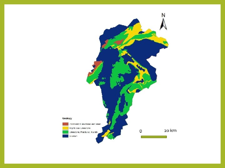
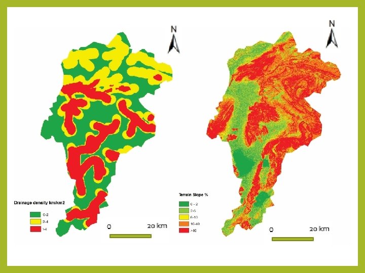
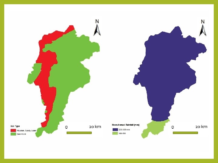
Classification of weighted factors influencing the MAR Criteria Domain of Affect Common Scale Geology Alluvium 1 Limestone, Fractured, Karstic 0. 9 Argillaceous Limestone 0. 3 Interbedded Limestone and shale 0. 2 0 -2 1 2 -6 0. 8 6 -10 0. 5 10 -40 0. 2 >40 0 Sandy Loam, Alluvium 1 Bare Rock 0. 2 0 -2 1 2 -4 0. 6 >4 0. 1 200 -300 0. 6 100 -200 0. 5 Slope % Soil Drainage Density km/km 2 Mean Annual Rainfall (mm)

Preparation of Maps • Geological Map: The map was obtained by digitizing a figure in the USGS Open-File Report 2100– 1093 (https: //pubs. usgs. gov/of/2011/1093/). • Slope Map: The slope map was prepared from SRTM DEM (https: //earthexplorer. usgs. gov/) using Arc. GIS Spatial Analyst module. • Soil Map: The soil map is produced from the existing soil map of Baluchistan, Pakistan. • Rain Map: The rain map is of the study area is adapted from Ahmed et al. , 2014 • Drainage Density: The drainage density map is prepared using the line density analysis tool in Arc. GIS from existing toposheet.

Suitability Mapping Geology, slope, rain, drainage density, and Soil maps are overlaid by Weighted Linear Combination method (Rahman et al. , 2012; Valverde et al. , 2016) to obtain final MAR suitability map.

Conclusions • Weighted linear combination overlay analysis shows that the western half of Quetta Valley is suitable for MAR implementation especially trenches, ditches and furrows. • In the urban areas of Quetta Valley rooftop harvesting would be the feasible method. • Water shortage in Quetta Valley can be ameliorated by using MAR techniques • The INOWAS platform is found useful to narrow down the MAR methods for the study area but it could be made more accurate by adding the options 1) temperature of the area, 2) precipitation and 3) depth to the water table under the tab of ‘MAR method selection’. • Integration of remote sensing and GIS is efficient for quick and wise decision making for groundwater resources management while minimizing the labor, money and time. Thank You For Your Attention!

Acknowledgement: "This work is part of a project that has received funding from the European Union’s Horizon 2020 research and innovation programme under grant agreement No 810980.

References • • • Ahmed, K. , Shahid, S. , & Harun, S. B. (2014). Spatial interpolation of climatic variables in a predominantly arid region with complex topography. Environment Systems and Decisions, 34(4), 555 -563. Bonilla Valverde, J. P. , Blank, C. , Roidt, M. , Schneider, L. , & Stefan, C. (2016). Application of a GIS multi-criteria decision analysis for the identification of intrinsic suitable sites in Costa Rica for the application of managed aquifer recharge (MAR) through spreading methods. Water, 8(9), 391. Kahlown, M. A. , & Kemper, W. D. (2007). Factors affecting success and failure of trickle irrigation systems in Balochistan, Pakistan. Irrigation science, 26(1), 71 -79. Kakar, N. , Kakar, D. M. , Khan, A. S. , & Khan, S. D. (2019). Land subsidence caused by groundwater exploitation in Quetta Valley, Pakistan. International Journal of Economic and Environmental Geology, 10 -19. M. Ashraf and Ashfaq A. Sheikh (2017). Sustainable Groundwater Management in Balochistan. Pakistan Council of Research in Water Resources (PCRWR), pp. 34. Malczewski, J. , & Rinner, C. (2015). Multicriteria decision analysis in geographic information science (pp. 220 -228). New York: Springer. Rahman, M. A. , Rusteberg, B. , Gogu, R. C. , Ferreira, J. L. , & Sauter, M. (2012). A new spatial multi-criteria decision support tool for site selection for implementation of managed aquifer recharge. Journal of environmental management, 99, 61 -75. https: //dss. inowas. com/tools (April, 2020) https: //pubs. usgs. gov/of/2011/1093/
- Slides: 26