MaddenJulian Oscillation Recent Evolution Current Status and Predictions
- Slides: 19

Madden-Julian Oscillation: Recent Evolution, Current Status and Predictions Update prepared by Climate Prediction Center / NCEP May 19, 2008

Outline • Overview • Recent Evolution and Current Conditions • MJO Index Information • MJO Index Forecasts • MJO Composites

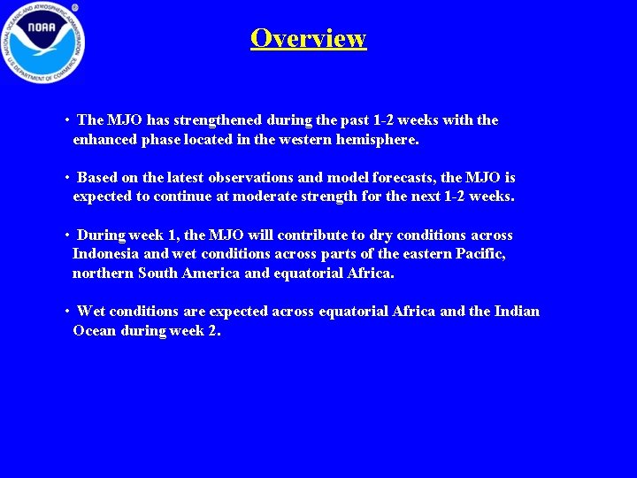
Overview • The MJO has strengthened during the past 1 -2 weeks with the enhanced phase located in the western hemisphere. • Based on the latest observations and model forecasts, the MJO is expected to continue at moderate strength for the next 1 -2 weeks. • During week 1, the MJO will contribute to dry conditions across Indonesia and wet conditions across parts of the eastern Pacific, northern South America and equatorial Africa. • Wet conditions are expected across equatorial Africa and the Indian Ocean during week 2.

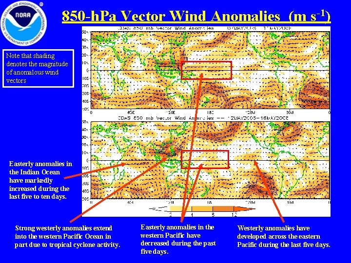
850 -h. Pa Vector Wind Anomalies (m s-1) Note that shading denotes the magnitude of anomalous wind vectors Easterly anomalies in the Indian Ocean have markedly increased during the last five to ten days. Strong westerly anomalies extend into the western Pacific Ocean in part due to tropical cyclone activity. Easterly anomalies in the western Pacific have decreased during the past five days. Westerly anomalies have developed across the eastern Pacific during the last five days.

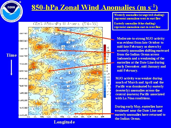
850 -h. Pa Zonal Wind Anomalies (m s-1) Westerly anomalies (orange/red shading) represent anomalous west-to-east flow Easterly anomalies (blue shading) represent anomalous east-to-west flow Moderate-to-strong MJO activity was evident from late October to mid-late February as shown by westerly anomalies shifting eastward from the Indian Ocean across Indonesia and a weakening of the easterlies at the Date Line during early December, mid-January and mid-February. Time MJO activity was weaker during much of March and April and the Pacific was dominated by easterly (westerly) anomalies across the central (eastern) Pacific associated with La Nina conditions. Longitude During early May, easterlies have weakened near the Date Line and easterly anomalies have returned to the Indian Ocean.

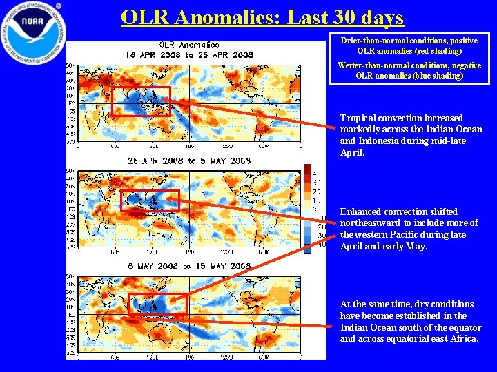
OLR Anomalies: Last 30 days Drier-than-normal conditions, positive OLR anomalies (red shading) Wetter-than-normal conditions, negative OLR anomalies (blue shading) Tropical convection increased markedly across the Indian Ocean and Indonesia during mid-late April. Enhanced convection shifted northeastward to include more of the western Pacific during late April and early May. At the same time, dry conditions have become established in the Indian Ocean south of the equator and across equatorial east Africa.

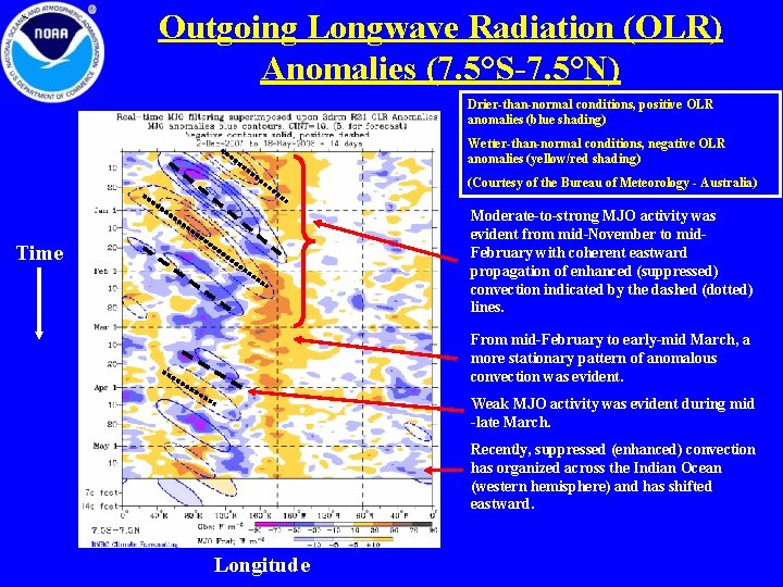
> Outgoing Longwave Radiation (OLR) Anomalies (7. 5°S-7. 5°N) Drier-than-normal conditions, positive OLR anomalies (blue shading) Wetter-than-normal conditions, negative OLR anomalies (yellow/red shading) (Courtesy of the Bureau of Meteorology - Australia) Moderate-to-strong MJO activity was evident from mid-November to mid. February with coherent eastward propagation of enhanced (suppressed) convection indicated by the dashed (dotted) lines. Time From mid-February to early-mid March, a more stationary pattern of anomalous convection was evident. Weak MJO activity was evident during mid -late March. Recently, suppressed (enhanced) convection has organized across the Indian Ocean (western hemisphere) and has shifted eastward. Longitude

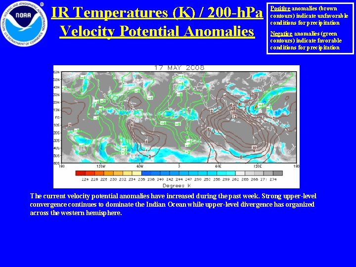
IR Temperatures (K) / 200 -h. Pa Velocity Potential Anomalies Positive anomalies (brown contours) indicate unfavorable conditions for precipitation Negative anomalies (green contours) indicate favorable conditions for precipitation The current velocity potential anomalies have increased during the past week. Strong upper-level convergence continues to dominate the Indian Ocean while upper-level divergence has organized across the western hemisphere.

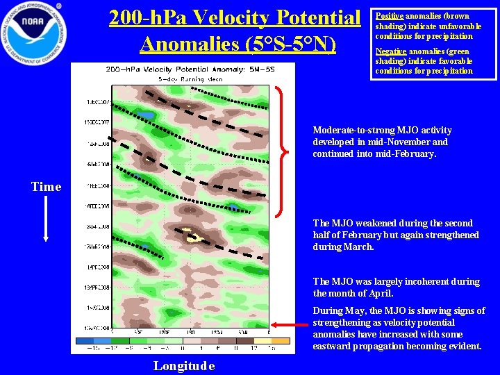
200 -h. Pa Velocity Potential Anomalies (5°S-5°N) Positive anomalies (brown shading) indicate unfavorable conditions for precipitation Negative anomalies (green shading) indicate favorable conditions for precipitation Moderate-to-strong MJO activity developed in mid-November and continued into mid-February. Time The MJO weakened during the second half of February but again strengthened during March. The MJO was largely incoherent during the month of April. During May, the MJO is showing signs of strengthening as velocity potential anomalies have increased with some eastward propagation becoming evident. Longitude

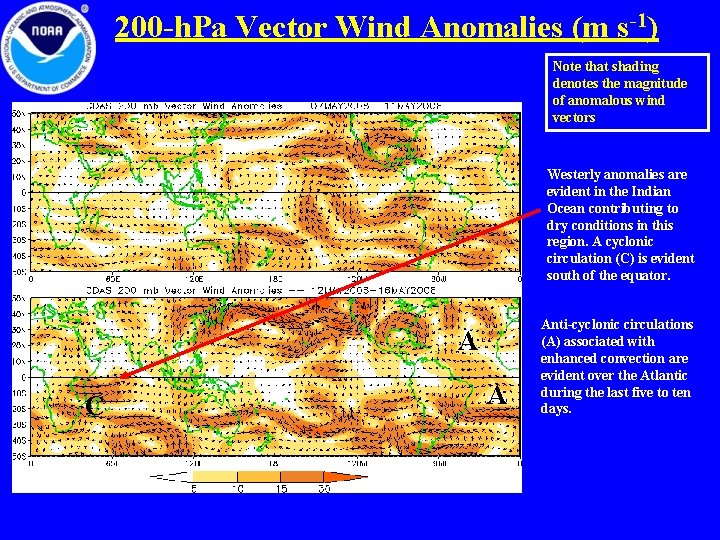
200 -h. Pa Vector Wind Anomalies (m s-1) Note that shading denotes the magnitude of anomalous wind vectors Westerly anomalies are evident in the Indian Ocean contributing to dry conditions in this region. A cyclonic circulation (C) is evident south of the equator. A C A Anti-cyclonic circulations (A) associated with enhanced convection are evident over the Atlantic during the last five to ten days.

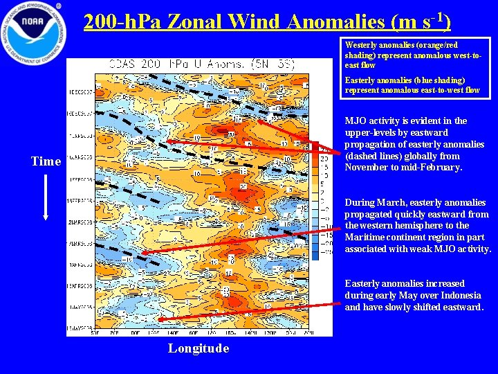
200 -h. Pa Zonal Wind Anomalies (m s-1) Westerly anomalies (orange/red shading) represent anomalous west-toeast flow Easterly anomalies (blue shading) represent anomalous east-to-west flow MJO activity is evident in the upper-levels by eastward propagation of easterly anomalies (dashed lines) globally from November to mid-February. Time During March, easterly anomalies propagated quickly eastward from the western hemisphere to the Maritime continent region in part associated with weak MJO activity. Easterly anomalies increased during early May over Indonesia and have slowly shifted eastward. Longitude

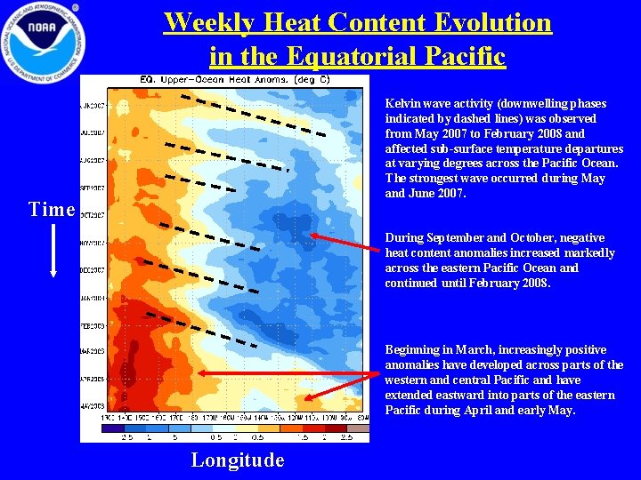
Weekly Heat Content Evolution in the Equatorial Pacific Kelvin wave activity (downwelling phases indicated by dashed lines) was observed from May 2007 to February 2008 and affected sub-surface temperature departures at varying degrees across the Pacific Ocean. The strongest wave occurred during May and June 2007. Time During September and October, negative heat content anomalies increased markedly across the eastern Pacific Ocean and continued until February 2008. Beginning in March, increasingly positive anomalies have developed across parts of the western and central Pacific and have extended eastward into parts of the eastern Pacific during April and early May. Longitude

MJO Index -- Information • The MJO index illustrated on the next several slides is the CPC version of the Wheeler and Hendon index (2004, hereafter WH 2004). Wheeler M. and H. Hendon, 2004: An All-Season Real-Time Multivariate MJO Index: Development of an Index for Monitoring and Prediction, Monthly Weather Review, 132, 1917 -1932. • The methodology is nearly identical to that described in WH 2004 but small deviations from the BMRC figure are possible at times due to differences in input data and methodology. These typically occur during weak MJO periods. • The index is based on a combined Empirical Orthogonal Function (EOF) analysis using fields of near-equatorially-averaged 850 -h. Pa and 200 -h. Pa zonal wind and outgoing longwave radiation (OLR).

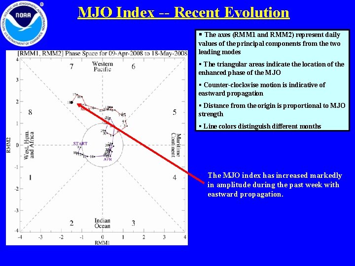
MJO Index -- Recent Evolution § The axes (RMM 1 and RMM 2) represent daily values of the principal components from the two leading modes § The triangular areas indicate the location of the enhanced phase of the MJO § Counter-clockwise motion is indicative of eastward propagation § Distance from the origin is proportional to MJO strength § Line colors distinguish different months The MJO index has increased markedly in amplitude during the past week with eastward propagation.

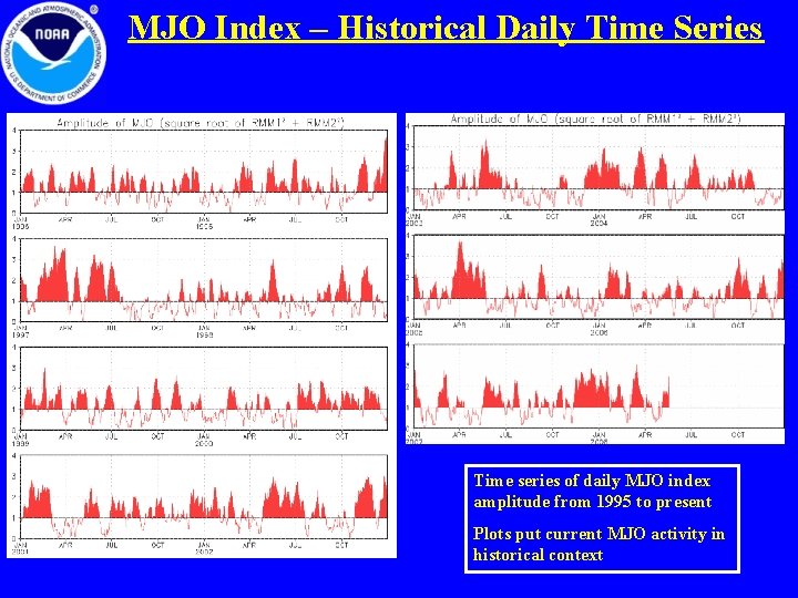
MJO Index – Historical Daily Time Series Time series of daily MJO index amplitude from 1995 to present Plots put current MJO activity in historical context

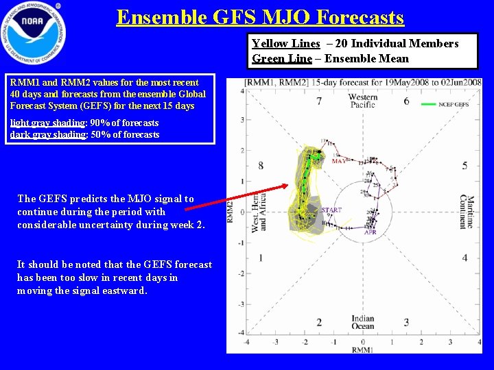
Ensemble GFS MJO Forecasts Yellow Lines – 20 Individual Members Green Line – Ensemble Mean RMM 1 and RMM 2 values for the most recent 40 days and forecasts from the ensemble Global Forecast System (GEFS) for the next 15 days light gray shading: 90% of forecasts dark gray shading: 50% of forecasts The GEFS predicts the MJO signal to continue during the period with considerable uncertainty during week 2. It should be noted that the GEFS forecast has been too slow in recent days in moving the signal eastward.

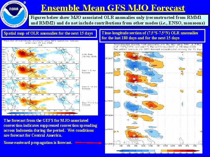
Ensemble Mean GFS MJO Forecast Figures below show MJO associated OLR anomalies only (reconstructed from RMM 1 and RMM 2) and do not include contributions from other modes (i. e. , ENSO, monsoons) Spatial map of OLR anomalies for the next 15 days The forecast from the GEFS for MJO-associated convection indicates suppressed convection spreading across Indonesia during the period. Wet conditions are forecast for Central America. Some eastward propagation is forecast. Time-longitude section of (7. 5°S-7. 5°N) OLR anomalies for the last 180 days and for the next 15 days

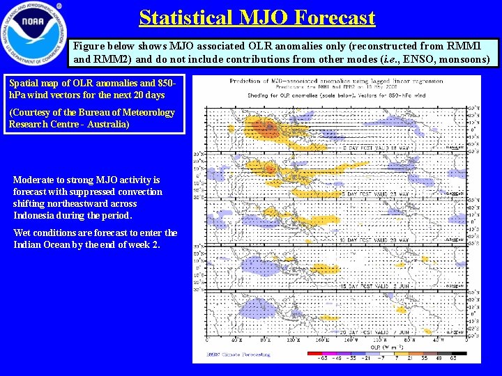
Statistical MJO Forecast Figure below shows MJO associated OLR anomalies only (reconstructed from RMM 1 and RMM 2) and do not include contributions from other modes (i. e. , ENSO, monsoons) Spatial map of OLR anomalies and 850 h. Pa wind vectors for the next 20 days (Courtesy of the Bureau of Meteorology Research Centre - Australia) Moderate to strong MJO activity is forecast with suppressed convection shifting northeastward across Indonesia during the period. Wet conditions are forecast to enter the Indian Ocean by the end of week 2.

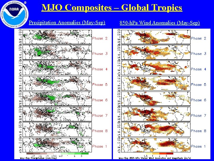
MJO Composites – Global Tropics Precipitation Anomalies (May-Sep) 850 -h. Pa Wind Anomalies (May-Sep)