MaddenJulian Oscillation Recent Evolution Current Status and Predictions
- Slides: 21

Madden-Julian Oscillation: Recent Evolution, Current Status and Predictions Update prepared by: Climate Prediction Center / NCEP 18 September 2017

Outline Overview Recent Evolution and Current Conditions MJO Index Information MJO Index Forecasts MJO Composites

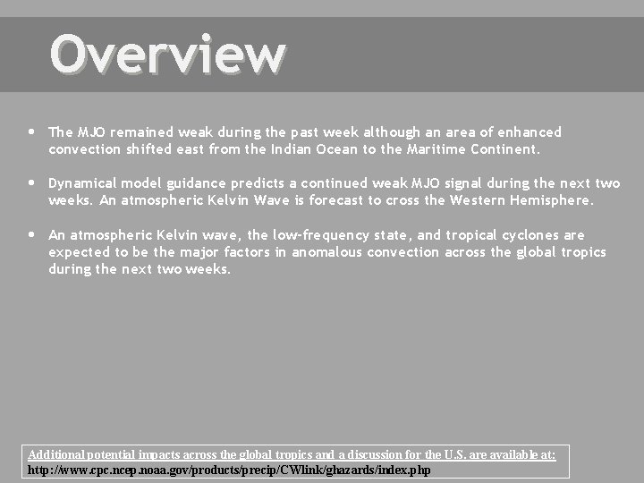
Overview The MJO remained weak during the past week although an area of enhanced convection shifted east from the Indian Ocean to the Maritime Continent. Dynamical model guidance predicts a continued weak MJO signal during the next two weeks. An atmospheric Kelvin Wave is forecast to cross the Western Hemisphere. An atmospheric Kelvin wave, the low-frequency state, and tropical cyclones are expected to be the major factors in anomalous convection across the global tropics during the next two weeks. Additional potential impacts across the global tropics and a discussion for the U. S. are available at: http: //www. cpc. ncep. noaa. gov/products/precip/CWlink/ghazards/index. php

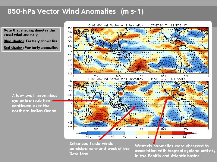
850 -h. Pa Vector Wind Anomalies (m s-1) Note that shading denotes the zonal wind anomaly Blue shades: Easterly anomalies Red shades: Westerly anomalies A low-level, anomalous cyclonic circulation continued over the northern Indian Ocean. Enhanced trade winds persisted near and west of the Date Line. Westerly anomalies were observed in association with tropical cyclone activity in the Pacific and Atlantic basins.

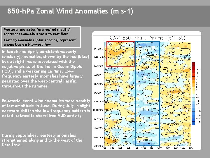
850 -h. Pa Zonal Wind Anomalies (m s-1) Westerly anomalies (orange/red shading) represent anomalous west-to-east flow Easterly anomalies (blue shading) represent anomalous east-to-west flow In March and April, persistent westerly (easterly) anomalies, shown by the red (blue) box at right, were associated with the negative phase of the Indian Ocean Dipole (IOD), and a weakening La Niña. Lowfrequency easterly anomalies have largely persisted over the west-central Pacific throughout the summer. Equatorial zonal wind anomalies were notably of low amplitude in June. During July, a slight eastward shift in the low-frequency pattern is noted, related to short-lived MJO activity. During September, easterly anomalies strengthened along and to the west of the Date Line.

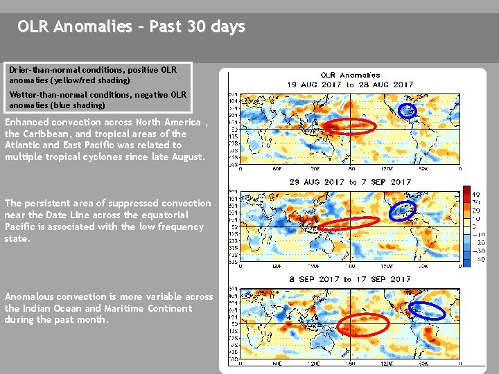
OLR Anomalies – Past 30 days Drier-than-normal conditions, positive OLR anomalies (yellow/red shading) Wetter-than-normal conditions, negative OLR anomalies (blue shading) Enhanced convection across North America , the Caribbean, and tropical areas of the Atlantic and East Pacific was related to multiple tropical cyclones since late August. The persistent area of suppressed convection near the Date Line across the equatorial Pacific is associated with the low frequency state. Anomalous convection is more variable across the Indian Ocean and Maritime Continent during the past month.

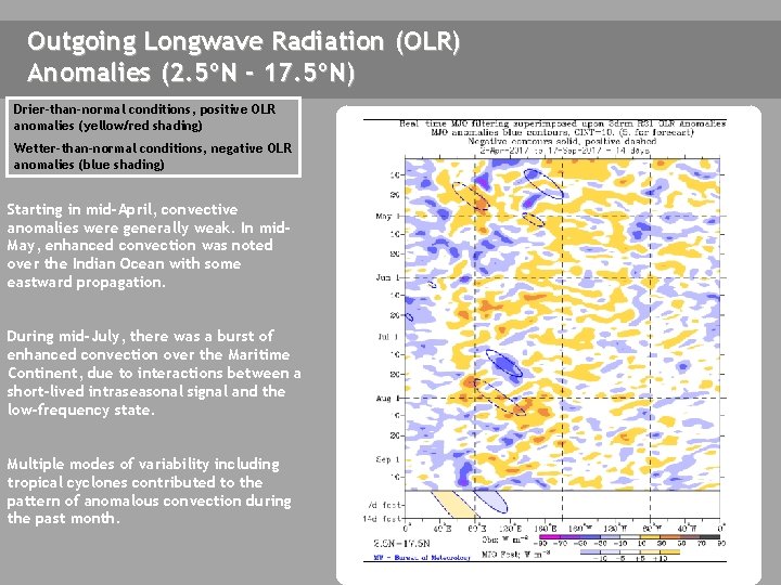
Outgoing Longwave Radiation (OLR) Anomalies (2. 5ºN - 17. 5ºN) Drier-than-normal conditions, positive OLR anomalies (yellow/red shading) Wetter-than-normal conditions, negative OLR anomalies (blue shading) Starting in mid-April, convective anomalies were generally weak. In mid. May, enhanced convection was noted over the Indian Ocean with some eastward propagation. During mid-July, there was a burst of enhanced convection over the Maritime Continent, due to interactions between a short-lived intraseasonal signal and the low-frequency state. Multiple modes of variability including tropical cyclones contributed to the pattern of anomalous convection during the past month.

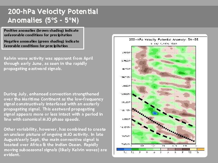
200 -h. Pa Velocity Potential Anomalies (5ºS - 5ºN) Positive anomalies (brown shading) indicate unfavorable conditions for precipitation Negative anomalies (green shading) indicate favorable conditions for precipitation Kelvin wave activity was apparent from April through early June, as seen in the rapidly propagating eastward signals. During July, enhanced convection strengthened over the Maritime Continent as the low-frequency signal constructively interfered with an easterly propagating signal. This eastward propagating signal appears more or less intact with a period in line with canonical MJO phase speeds. Other variability, however, has combined to create an unclear picture of ongoing MJO activity. In late August/early Sept, the main convective signal is located over Africa & the Indian Ocean. Rapidly moving subseasonal signals (likely Kelvin waves) are evident.

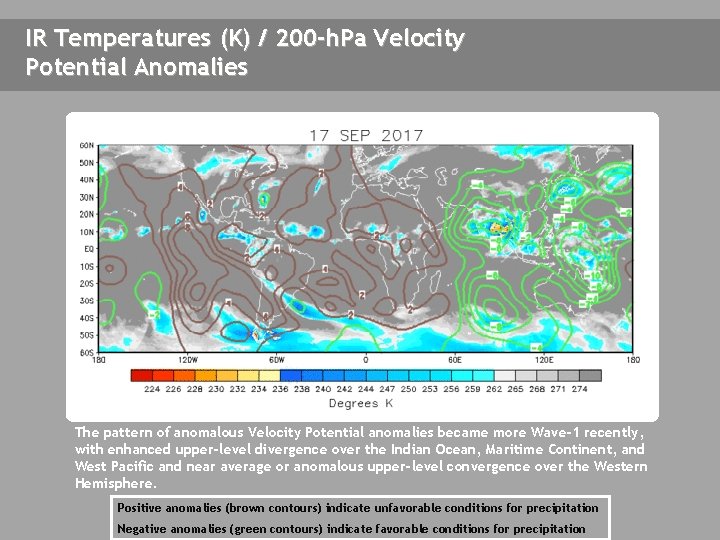
IR Temperatures (K) / 200 -h. Pa Velocity Potential Anomalies THIS SLIDE NOT UPDATED The pattern of anomalous Velocity Potential anomalies became more Wave-1 recently, with enhanced upper-level divergence over the Indian Ocean, Maritime Continent, and West Pacific and near average or anomalous upper-level convergence over the Western Hemisphere. Positive anomalies (brown contours) indicate unfavorable conditions for precipitation Negative anomalies (green contours) indicate favorable conditions for precipitation

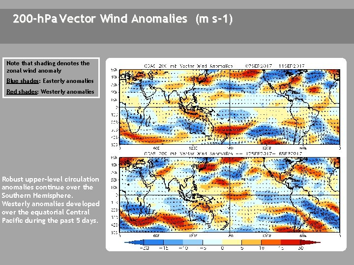
200 -h. Pa Vector Wind Anomalies (m s-1) Note that shading denotes the zonal wind anomaly Blue shades: Easterly anomalies Red shades: Westerly anomalies Robust upper-level circulation anomalies continue over the Southern Hemisphere. Westerly anomalies developed over the equatorial Central Pacific during the past 5 days. A NOT AVAILABLE C A A CA

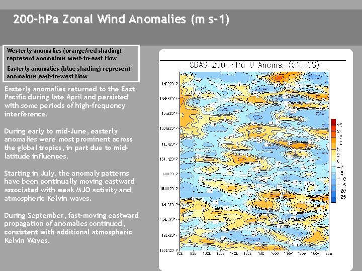
200 -h. Pa Zonal Wind Anomalies (m s-1) Westerly anomalies (orange/red shading) represent anomalous west-to-east flow Easterly anomalies (blue shading) represent anomalous east-to-west flow Easterly anomalies returned to the East Pacific during late April and persisted with some periods of high-frequency interference. During early to mid-June, easterly anomalies were most prominent across the global tropics, in part due to midlatitude influences. Starting in July, the anomaly patterns have been continually moving eastward associated with weak MJO activity and atmospheric Kelvin waves. During September, fast-moving eastward propagation of anomalies continued, consistent with additional atmospheric Kelvin Waves.

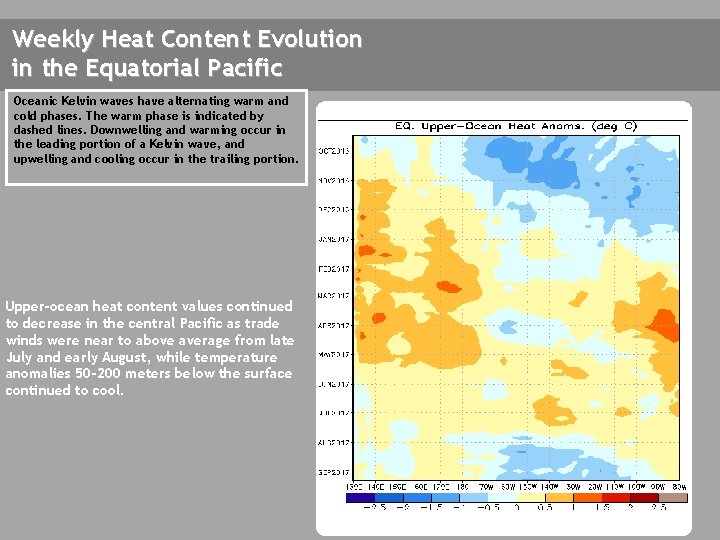
Weekly Heat Content Evolution in the Equatorial Pacific Oceanic Kelvin waves have alternating warm and cold phases. The warm phase is indicated by dashed lines. Downwelling and warming occur in the leading portion of a Kelvin wave, and upwelling and cooling occur in the trailing portion. Upper-ocean heat content values continued to decrease in the central Pacific as trade winds were near to above average from late July and early August, while temperature anomalies 50 -200 meters below the surface continued to cool.

MJO Index -- Information The MJO index illustrated on the next several slides is the CPC version of the Wheeler and Hendon index (2004, hereafter WH 2004). Wheeler M. and H. Hendon, 2004: An All-Season Real-Time Multivariate MJO Index: Development of an Index for Monitoring and Prediction, Monthly Weather Review, 132, 1917 -1932. The methodology is very similar to that described in WH 2004 but does not include the linear removal of ENSO variability associated with a sea surface temperature index. The methodology is consistent with that outlined by the U. S. CLIVAR MJO Working Group. Gottschalck et al. 2010: A Framework for Assessing Operational Madden-Julian Oscillation Forecasts: A CLIVAR MJO Working Group Project, Bull. Amer. Met. Soc. , 91, 1247 -1258. The index is based on a combined Empirical Orthogonal Function (EOF) analysis using fields of near-equatorially-averaged 850 -h. Pa and 200 -h. Pa zonal wind and outgoing longwave radiation (OLR).

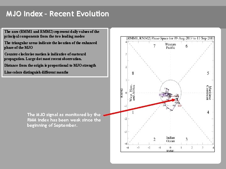
MJO Index – Recent Evolution The axes (RMM 1 and RMM 2) represent daily values of the principal components from the two leading modes The triangular areas indicate the location of the enhanced phase of the MJO Counter-clockwise motion is indicative of eastward propagation. Large dot most recent observation. Distance from the origin is proportional to MJO strength Line colors distinguish different months The MJO signal as monitored by the RMM index has been weak since the beginning of September.

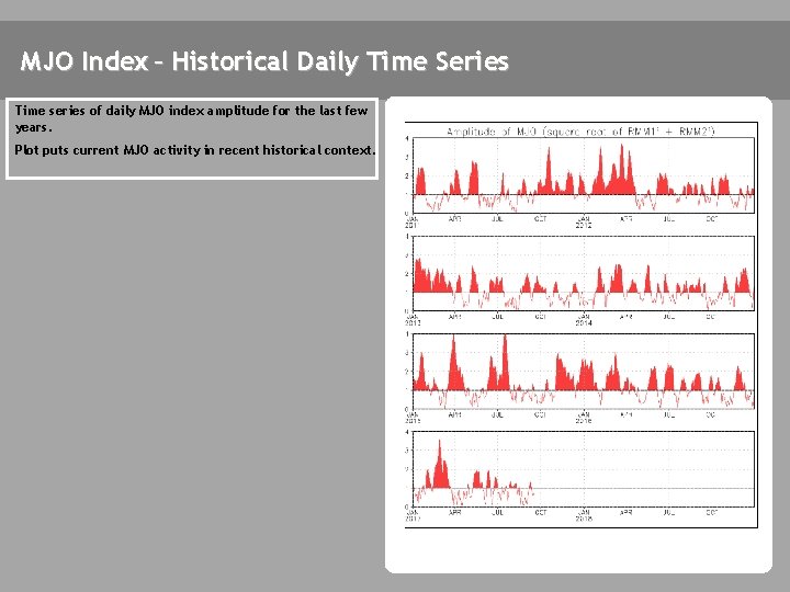
MJO Index – Historical Daily Time Series Time series of daily MJO index amplitude for the last few years. Plot puts current MJO activity in recent historical context.

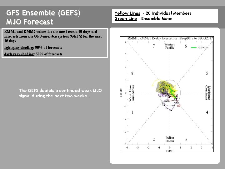
GFS Ensemble (GEFS) MJO Forecast RMM 1 and RMM 2 values for the most recent 40 days and forecasts from the GFS ensemble system (GEFS) for the next 15 days light gray shading: 90% of forecasts dark gray shading: 50% of forecasts The GEFS depicts a continued weak MJO signal during the next two weeks. Yellow Lines – 20 Individual Members Green Line – Ensemble Mean

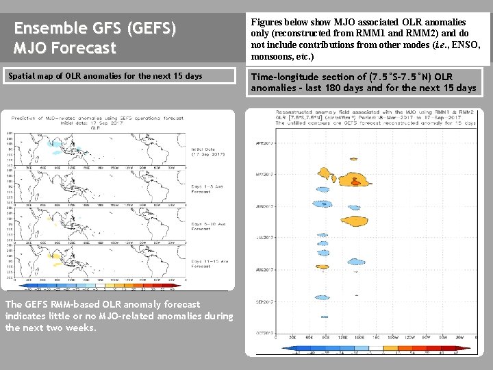
Ensemble GFS (GEFS) MJO Forecast Spatial map of OLR anomalies for the next 15 days The GEFS plot of MJO related OLR anomalies is unavailable at this time. The GEFS RMM-based OLR anomaly forecast indicates little or no MJO-related anomalies during the next two weeks. Figures below show MJO associated OLR anomalies only (reconstructed from RMM 1 and RMM 2) and do not include contributions from other modes (i. e. , ENSO, monsoons, etc. ) Time-longitude section of (7. 5°S-7. 5°N) OLR anomalies - last 180 days and for the next 15 days The GEFS plot of MJO related OLR anomalies is unavailable at this time.

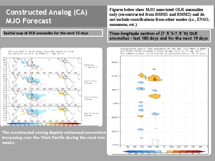
Constructed Analog (CA) MJO Forecast Figures below show MJO associated OLR anomalies only (reconstructed from RMM 1 and RMM 2) and do not include contributions from other modes (i. e. , ENSO, monsoons, etc. ) Spatial map of OLR anomalies for the next 15 days Time-longitude section of (7. 5°S-7. 5°N) OLR anomalies - last 180 days and for the next 15 days The constructed analog depicts enhanced convection increasing over the West Pacific during the next two weeks.

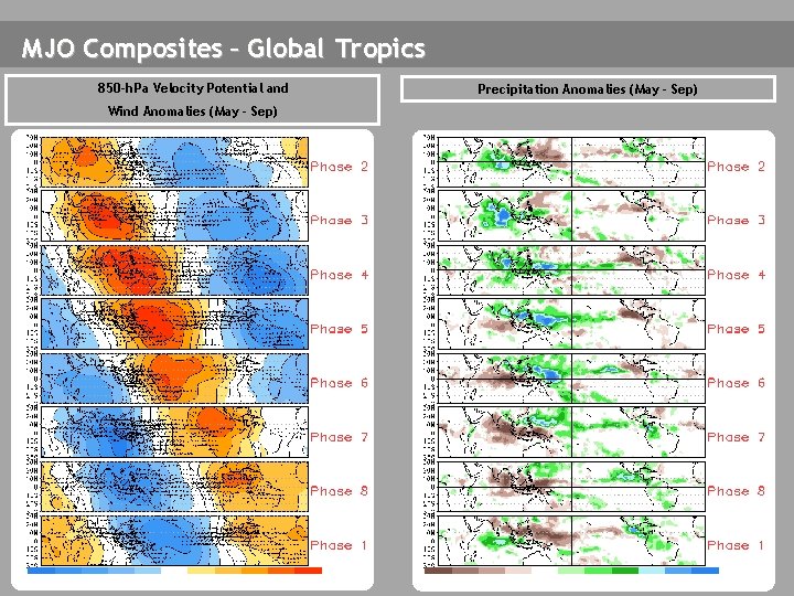
MJO Composites – Global Tropics 850 -h. Pa Velocity Potential and Wind Anomalies (May - Sep) Precipitation Anomalies (May - Sep)

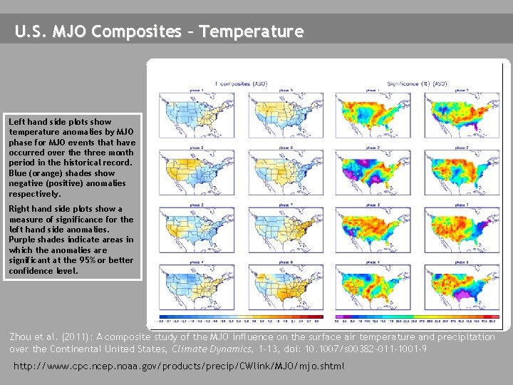
U. S. MJO Composites – Temperature Left hand side plots show temperature anomalies by MJO phase for MJO events that have occurred over the three month period in the historical record. Blue (orange) shades show negative (positive) anomalies respectively. Right hand side plots show a measure of significance for the left hand side anomalies. Purple shades indicate areas in which the anomalies are significant at the 95% or better confidence level. Zhou et al. (2011): A composite study of the MJO influence on the surface air temperature and precipitation over the Continental United States, Climate Dynamics, 1 -13, doi: 10. 1007/s 00382 -011 -1001 -9 http: //www. cpc. ncep. noaa. gov/products/precip/CWlink/MJO/mjo. shtml

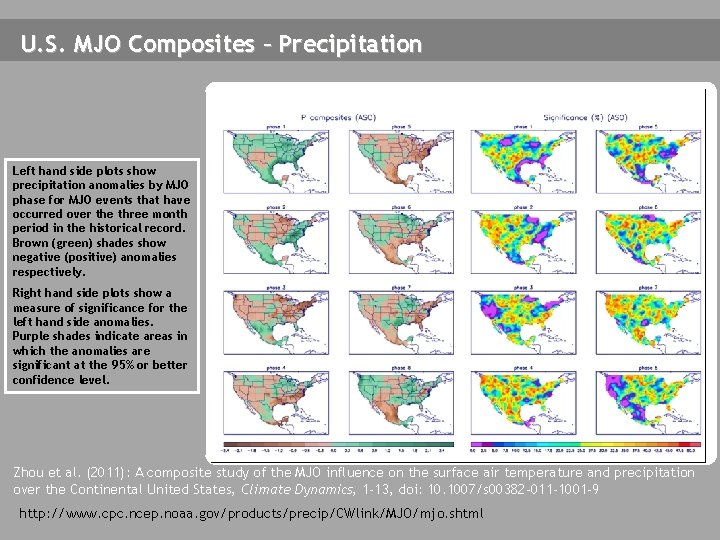
U. S. MJO Composites – Precipitation Left hand side plots show precipitation anomalies by MJO phase for MJO events that have occurred over the three month period in the historical record. Brown (green) shades show negative (positive) anomalies respectively. Right hand side plots show a measure of significance for the left hand side anomalies. Purple shades indicate areas in which the anomalies are significant at the 95% or better confidence level. Zhou et al. (2011): A composite study of the MJO influence on the surface air temperature and precipitation over the Continental United States, Climate Dynamics, 1 -13, doi: 10. 1007/s 00382 -011 -1001 -9 http: //www. cpc. ncep. noaa. gov/products/precip/CWlink/MJO/mjo. shtml