MaddenJulian Oscillation Recent Evolution Current Status and Predictions
- Slides: 12

Madden-Julian Oscillation: Recent Evolution, Current Status and Predictions Update prepared by Climate Prediction Center / NCEP September 17, 2007

Outline • Overview • Recent Evolution and Current Conditions • Madden-Julian Oscillation Forecast

Overview • The latest observations indicate that the MJO is incoherent. • During the past week, enhanced convection has organized across a large region stretching from the far western Pacific Ocean to the Bay of Bengal including sections of the Maritime Continent and Southeast Asia. • Western Africa received a respite from the very wet conditions of the last few weeks. • Based on the latest monitoring and forecast tools, weak MJO activity is expected during the next 1 -2 weeks.

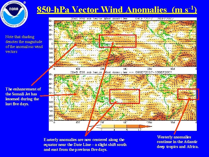
850 -h. Pa Vector Wind Anomalies (m s-1) Note that shading denotes the magnitude of the anomalous wind vectors The enhancement of the Somali Jet has lessened during the last five days. Easterly anomalies are now centered along the equator near the Date Line – a slight shift south and east from the previous five days. Westerly anomalies continue in the Atlantic deep tropics and Africa.

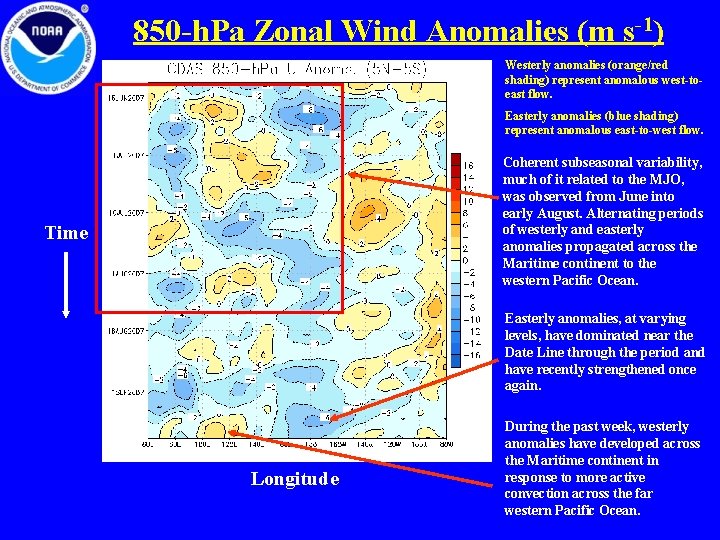
850 -h. Pa Zonal Wind Anomalies (m s-1) Westerly anomalies (orange/red shading) represent anomalous west-toeast flow. Easterly anomalies (blue shading) represent anomalous east-to-west flow. Coherent subseasonal variability, much of it related to the MJO, was observed from June into early August. Alternating periods of westerly and easterly anomalies propagated across the Maritime continent to the western Pacific Ocean. Time Easterly anomalies, at varying levels, have dominated near the Date Line through the period and have recently strengthened once again. Longitude During the past week, westerly anomalies have developed across the Maritime continent in response to more active convection across the far western Pacific Ocean.

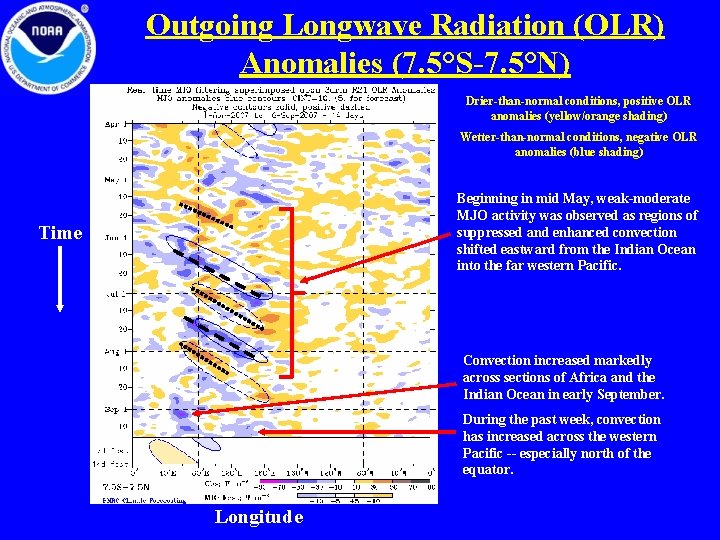
Outgoing Longwave Radiation (OLR) Anomalies (7. 5°S-7. 5°N) Drier-than-normal conditions, positive OLR anomalies (yellow/orange shading) Wetter-than-normal conditions, negative OLR anomalies (blue shading) Beginning in mid May, weak-moderate MJO activity was observed as regions of suppressed and enhanced convection shifted eastward from the Indian Ocean into the far western Pacific. Time Convection increased markedly across sections of Africa and the Indian Ocean in early September. During the past week, convection has increased across the western Pacific -- especially north of the equator. Longitude

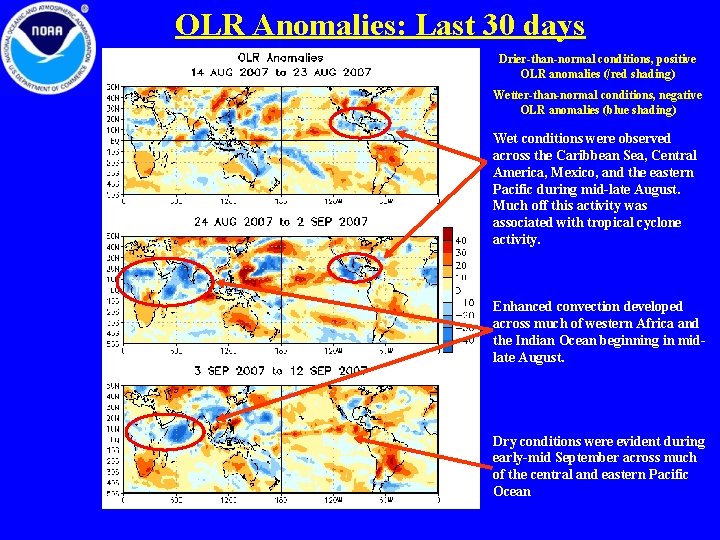
OLR Anomalies: Last 30 days Drier-than-normal conditions, positive OLR anomalies (/red shading) Wetter-than-normal conditions, negative OLR anomalies (blue shading) Wet conditions were observed across the Caribbean Sea, Central America, Mexico, and the eastern Pacific during mid-late August. Much off this activity was associated with tropical cyclone activity. Enhanced convection developed across much of western Africa and the Indian Ocean beginning in midlate August. Dry conditions were evident during early-mid September across much of the central and eastern Pacific Ocean

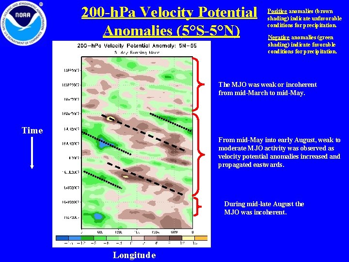
200 -h. Pa Velocity Potential Anomalies (5°S-5°N) Positive anomalies (brown shading) indicate unfavorable conditions for precipitation. Negative anomalies (green shading) indicate favorable conditions for precipitation. The MJO was weak or incoherent from mid-March to mid-May. Time From mid-May into early August, weak to moderate MJO activity was observed as velocity potential anomalies increased and propagated eastwards. During mid-late August the MJO was incoherent. Longitude

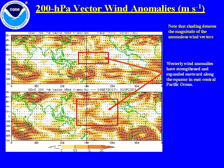
200 -h. Pa Vector Wind Anomalies (m s-1) Note that shading denotes the magnitude of the anomalous wind vectors Westerly wind anomalies have strengthened and expanded eastward along the equator in east-central Pacific Ocean.

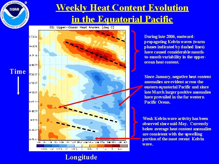
Weekly Heat Content Evolution in the Equatorial Pacific During late 2006, eastwardpropagating Kelvin waves (warm phases indicated by dashed lines) have caused considerable monthto-month variability in the upperocean heat content. Time Since January, negative heat content anomalies are evident across the eastern equatorial Pacific and since late March larger positive anomalies have prevailed in the far western Pacific Ocean. Weak Kelvin wave activity has been observed since mid-May. Currently below average heat content anomalies are consistent with the upwelling portion of the most recent Kelvin wave. Longitude

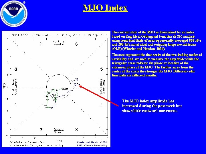
MJO Index The current state of the MJO as determined by an index based on Empirical Orthogonal Function (EOF) analysis using combined fields of near-equatorially-averaged 850 -h. Pa and 200 -h. Pa zonal wind and outgoing longwave radiation (OLR) (Wheeler and Hendon, 2004). The axes represent the time series of the two leading modes of variability and are used to measure the amplitude while the triangular areas indicate the phase or location of the enhanced phase of the MJO. The farther away from the center of the circle the stronger the MJO. Different color lines indicate different months. The MJO index amplitude has increased during the past week but shows little eastward movement.

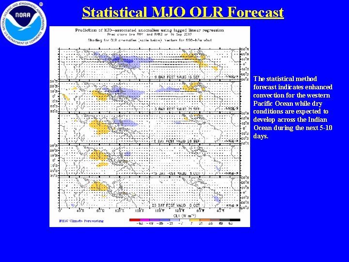
Statistical MJO OLR Forecast The statistical method forecast indicates enhanced convection for the western Pacific Ocean while dry conditions are expected to develop across the Indian Ocean during the next 5 -10 days.