MaddenJulian Oscillation Recent Evolution Current Status and Predictions
- Slides: 19

Madden-Julian Oscillation: Recent Evolution, Current Status and Predictions Update prepared by Climate Prediction Center / NCEP April 20, 2009

Outline • Overview • Recent Evolution and Current Conditions • MJO Index Information • MJO Index Forecasts • MJO Composites

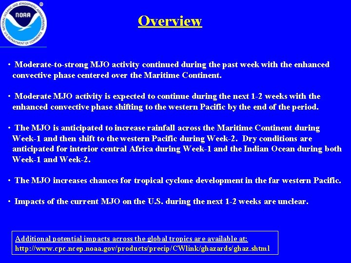
Overview • Moderate-to-strong MJO activity continued during the past week with the enhanced convective phase centered over the Maritime Continent. • Moderate MJO activity is expected to continue during the next 1 -2 weeks with the enhanced convective phase shifting to the western Pacific by the end of the period. • The MJO is anticipated to increase rainfall across the Maritime Continent during Week-1 and then shift to the western Pacific during Week-2. Dry conditions are anticipated for interior central Africa during Week-1 and the Indian Ocean during both Week-1 and Week-2. • The MJO increases chances for tropical cyclone development in the far western Pacific. • Impacts of the current MJO on the U. S. during the next 1 -2 weeks are unclear. Additional potential impacts across the global tropics are available at: http: //www. cpc. ncep. noaa. gov/products/precip/CWlink/ghazards/ghaz. shtml

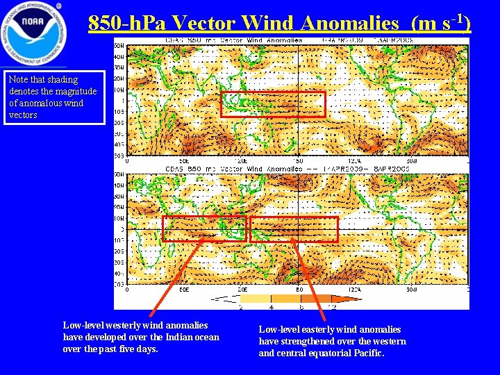
850 -h. Pa Vector Wind Anomalies (m s-1) Note that shading denotes the magnitude of anomalous wind vectors Low-level westerly wind anomalies have developed over the Indian ocean over the past five days. Low-level easterly wind anomalies have strengthened over the western and central equatorial Pacific.

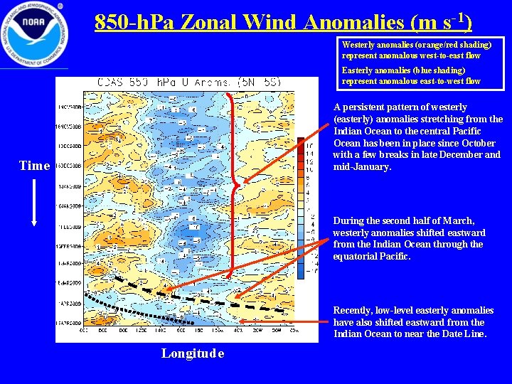
850 -h. Pa Zonal Wind Anomalies (m s-1) Westerly anomalies (orange/red shading) represent anomalous west-to-east flow Easterly anomalies (blue shading) represent anomalous east-to-west flow A persistent pattern of westerly (easterly) anomalies stretching from the Indian Ocean to the central Pacific Ocean has been in place since October with a few breaks in late December and mid-January. Time During the second half of March, westerly anomalies shifted eastward from the Indian Ocean through the equatorial Pacific. Recently, low-level easterly anomalies have also shifted eastward from the Indian Ocean to near the Date Line. Longitude

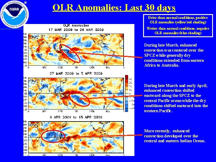
OLR Anomalies: Last 30 days Drier-than-normal conditions, positive OLR anomalies (yellow/red shading) Wetter-than-normal conditions, negative OLR anomalies (blue shading) During late March, enhanced convection was centered over the SPCZ while generally dry conditions extended from eastern Africa to Australia. During late March and early April, enhanced convection shifted eastward along the SPCZ to the central Pacific ocean while the dry conditions shifted eastward into the western Pacific. More recently, enhanced convection developed over the central and eastern Indian Ocean.

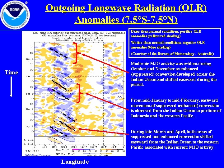
> Outgoing Longwave Radiation (OLR) Anomalies (7. 5°S-7. 5°N) Drier-than-normal conditions, positive OLR anomalies (yellow/red shading) Wetter-than-normal conditions, negative OLR anomalies (blue shading) (Courtesy of the Bureau of Meteorology - Australia) Moderate MJO activity was evident during October and November as enhanced (suppressed) convection developed across the Indian Ocean and shifted eastward during the period. Time From mid-January to mid-February, eastward movement of suppressed (enhanced) convection is observed from the Indian Ocean to portions of Indonesia and the western Pacific. During late March and April, both areas of suppressed and enhanced convection shifted eastward from the Indian Ocean to the western Pacific associated with current MJO activity. Longitude

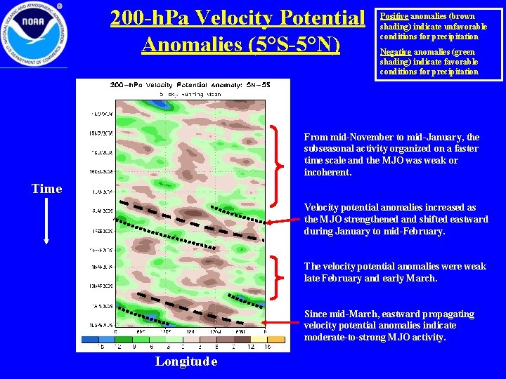
200 -h. Pa Velocity Potential Anomalies (5°S-5°N) Positive anomalies (brown shading) indicate unfavorable conditions for precipitation Negative anomalies (green shading) indicate favorable conditions for precipitation From mid-November to mid-January, the subseasonal activity organized on a faster time scale and the MJO was weak or incoherent. Time Velocity potential anomalies increased as the MJO strengthened and shifted eastward during January to mid-February. The velocity potential anomalies were weak late February and early March. Since mid-March, eastward propagating velocity potential anomalies indicate moderate-to-strong MJO activity. Longitude

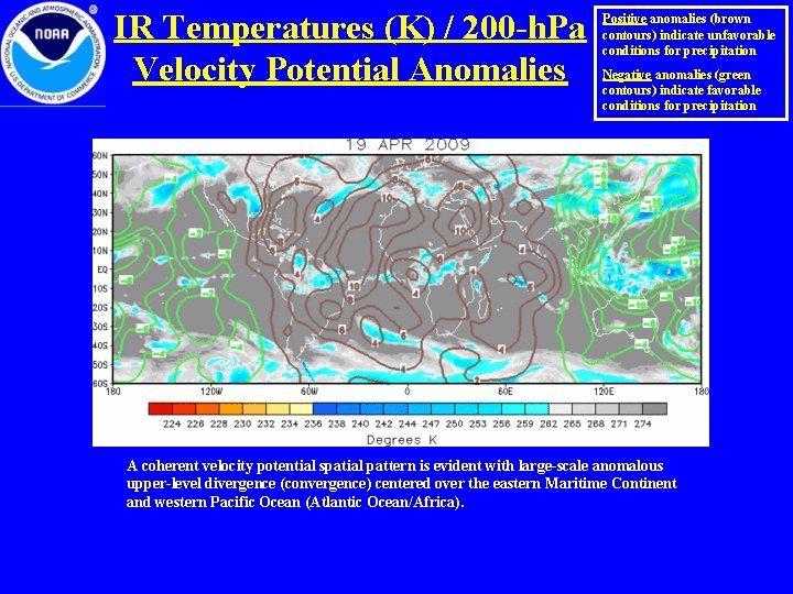
IR Temperatures (K) / 200 -h. Pa Velocity Potential Anomalies Positive anomalies (brown contours) indicate unfavorable conditions for precipitation Negative anomalies (green contours) indicate favorable conditions for precipitation A coherent velocity potential spatial pattern is evident with large-scale anomalous upper-level divergence (convergence) centered over the eastern Maritime Continent and western Pacific Ocean (Atlantic Ocean/Africa).

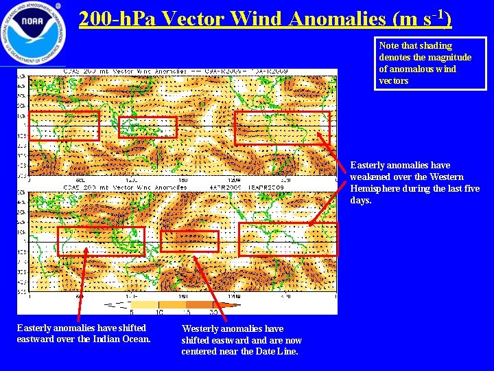
200 -h. Pa Vector Wind Anomalies (m s-1) Note that shading denotes the magnitude of anomalous wind vectors Easterly anomalies have weakened over the Western Hemisphere during the last five days. Easterly anomalies have shifted eastward over the Indian Ocean. Westerly anomalies have shifted eastward and are now centered near the Date Line.

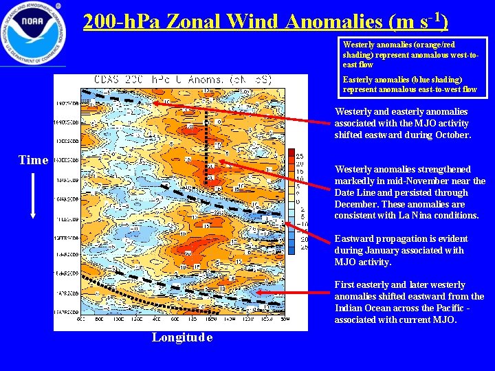
200 -h. Pa Zonal Wind Anomalies (m s-1) Westerly anomalies (orange/red shading) represent anomalous west-toeast flow Easterly anomalies (blue shading) represent anomalous east-to-west flow Westerly and easterly anomalies associated with the MJO activity shifted eastward during October. Time Westerly anomalies strengthened markedly in mid-November near the Date Line and persisted through December. These anomalies are consistent with La Nina conditions. Eastward propagation is evident during January associated with MJO activity. First easterly and later westerly anomalies shifted eastward from the Indian Ocean across the Pacific associated with current MJO. Longitude

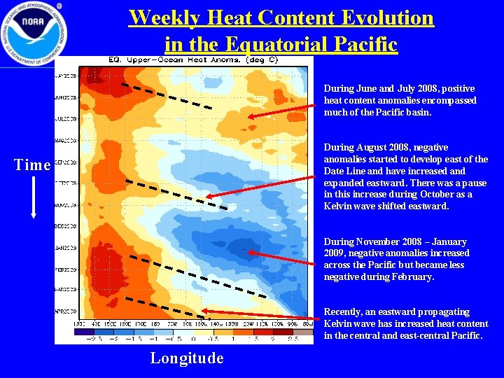
Weekly Heat Content Evolution in the Equatorial Pacific During June and July 2008, positive heat content anomalies encompassed much of the Pacific basin. During August 2008, negative anomalies started to develop east of the Date Line and have increased and expanded eastward. There was a pause in this increase during October as a Kelvin wave shifted eastward. Time During November 2008 – January 2009, negative anomalies increased across the Pacific but became less negative during February. Recently, an eastward propagating Kelvin wave has increased heat content in the central and east-central Pacific. Longitude

MJO Index -- Information • The MJO index illustrated on the next several slides is the CPC version of the Wheeler and Hendon index (2004, hereafter WH 2004). Wheeler M. and H. Hendon, 2004: An All-Season Real-Time Multivariate MJO Index: Development of an Index for Monitoring and Prediction, Monthly Weather Review, 132, 1917 -1932. • The methodology is nearly identical to that described in WH 2004 but small deviations from the BMRC figure are possible at times due to differences in input data and methodology. These typically occur during weak MJO periods. • The index is based on a combined Empirical Orthogonal Function (EOF) analysis using fields of near-equatorially-averaged 850 -h. Pa and 200 -h. Pa zonal wind and outgoing longwave radiation (OLR).

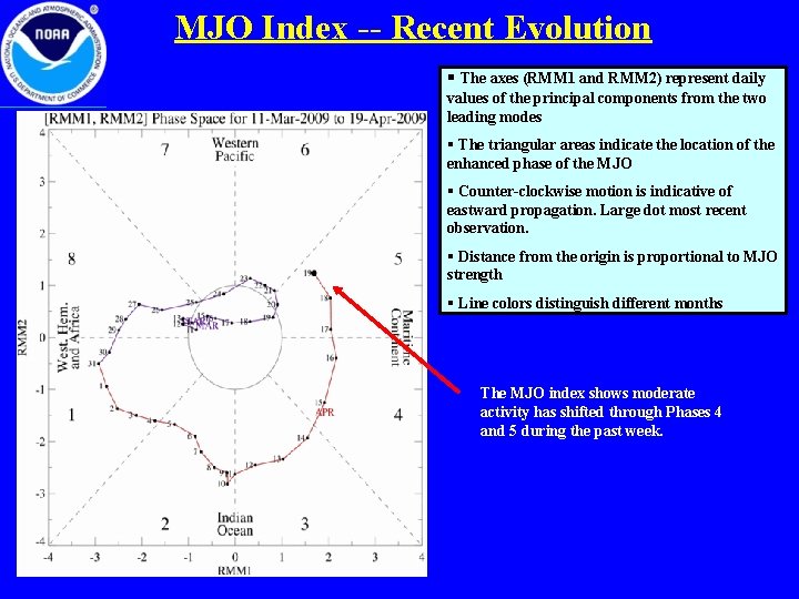
MJO Index -- Recent Evolution § The axes (RMM 1 and RMM 2) represent daily values of the principal components from the two leading modes § The triangular areas indicate the location of the enhanced phase of the MJO § Counter-clockwise motion is indicative of eastward propagation. Large dot most recent observation. § Distance from the origin is proportional to MJO strength § Line colors distinguish different months The MJO index shows moderate activity has shifted through Phases 4 and 5 during the past week.

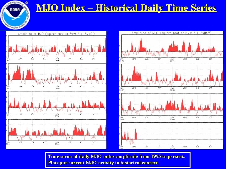
MJO Index – Historical Daily Time Series Time series of daily MJO index amplitude from 1995 to present. Plots put current MJO activity in historical context.

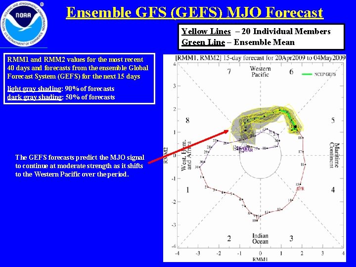
Ensemble GFS (GEFS) MJO Forecast Yellow Lines – 20 Individual Members Green Line – Ensemble Mean RMM 1 and RMM 2 values for the most recent 40 days and forecasts from the ensemble Global Forecast System (GEFS) for the next 15 days light gray shading: 90% of forecasts dark gray shading: 50% of forecasts The GEFS forecasts predict the MJO signal to continue at moderate strength as it shifts to the Western Pacific over the period.

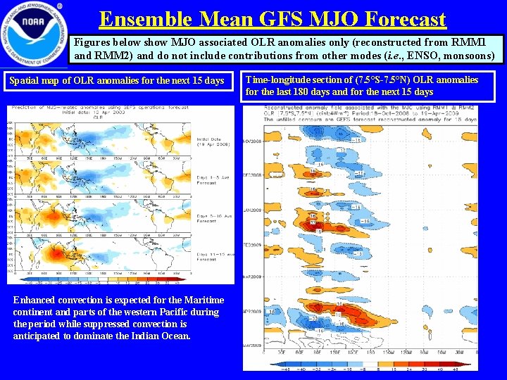
Ensemble Mean GFS MJO Forecast Figures below show MJO associated OLR anomalies only (reconstructed from RMM 1 and RMM 2) and do not include contributions from other modes (i. e. , ENSO, monsoons) Spatial map of OLR anomalies for the next 15 days Enhanced convection is expected for the Maritime continent and parts of the western Pacific during the period while suppressed convection is anticipated to dominate the Indian Ocean. Time-longitude section of (7. 5°S-7. 5°N) OLR anomalies for the last 180 days and for the next 15 days

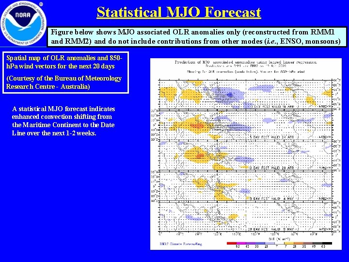
Statistical MJO Forecast Figure below shows MJO associated OLR anomalies only (reconstructed from RMM 1 and RMM 2) and do not include contributions from other modes (i. e. , ENSO, monsoons) Spatial map of OLR anomalies and 850 h. Pa wind vectors for the next 20 days (Courtesy of the Bureau of Meteorology Research Centre - Australia) A statistical MJO forecast indicates enhanced convection shifting from the Maritime Continent to the Date Line over the next 1 -2 weeks.

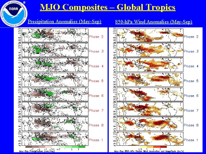
MJO Composites – Global Tropics Precipitation Anomalies (May-Sep) 850 -h. Pa Wind Anomalies (May-Sep)