MaddenJulian Oscillation Recent Evolution Current Status and Predictions
- Slides: 21

Madden-Julian Oscillation: Recent Evolution, Current Status and Predictions Update prepared by: Climate Prediction Center / NCEP 30 May 2016

Outline Overview Recent Evolution and Current Conditions MJO Index Information MJO Index Forecasts MJO Composites

Overview The MJO signal weakened as observed by the RMM index during the past week. However, continued eastward propagation of the upper-level velocity potential signal continued at phase speeds on the fast end of the MJO spectrum, with the enhanced phase centered over the Western Hemisphere. Enhanced convection has lingered over the eastern Indian Ocean and Southeast Asia, complicating the largescale pattern. Most dynamical models suggest that a weak MJO signal will continue over the Western Hemisphere early, followed by development of a more robust signal later in Week-2 over the western Indian Ocean. Any extratropical impacts of the MJO on the U. S. are anticipated to be negligible, given the typically weak teleconnections during this time of year. Additional potential impacts across the global tropics and a discussion for the U. S. are available at: http: //www. cpc. ncep. noaa. gov/products/precip/CWlink/ghazards/index. php

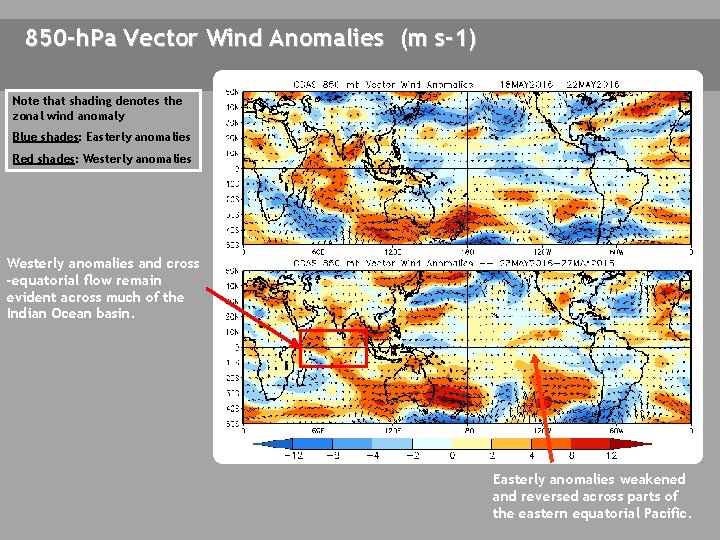
850 -h. Pa Vector Wind Anomalies (m s-1) Note that shading denotes the zonal wind anomaly Blue shades: Easterly anomalies Red shades: Westerly anomalies and cross -equatorial flow remain evident across much of the Indian Ocean basin. Easterly anomalies weakened and reversed across parts of the eastern equatorial Pacific.

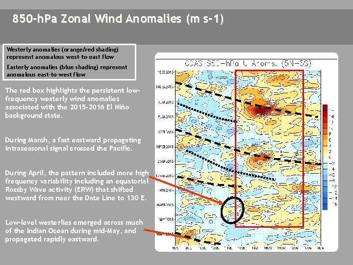
850 -h. Pa Zonal Wind Anomalies (m s-1) Westerly anomalies (orange/red shading) represent anomalous west-to-east flow Easterly anomalies (blue shading) represent anomalous east-to-west flow The red box highlights the persistent lowfrequency westerly wind anomalies associated with the 2015 -2016 El Niño background state. During March, a fast eastward propagating intraseasonal signal crossed the Pacific. During April, the pattern included more high frequency variability including an equatorial Rossby Wave activity (ERW) that shifted westward from near the Date Line to 130 E. Low-level westerlies emerged across much of the Indian Ocean during mid-May, and propagated rapidly eastward.

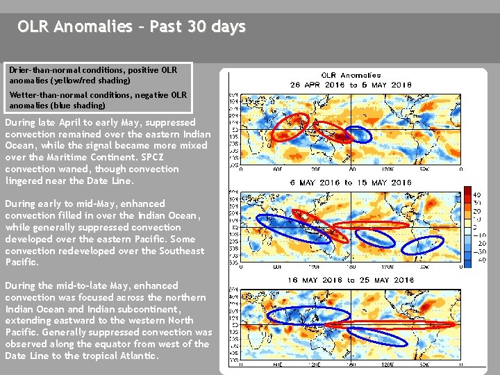
OLR Anomalies – Past 30 days Drier-than-normal conditions, positive OLR anomalies (yellow/red shading) Wetter-than-normal conditions, negative OLR anomalies (blue shading) During late April to early May, suppressed convection remained over the eastern Indian Ocean, while the signal became more mixed over the Maritime Continent. SPCZ convection waned, though convection lingered near the Date Line. During early to mid-May, enhanced convection filled in over the Indian Ocean, while generally suppressed convection developed over the eastern Pacific. Some convection redeveloped over the Southeast Pacific. During the mid-to-late May, enhanced convection was focused across the northern Indian Ocean and Indian subcontinent, extending eastward to the western North Pacific. Generally suppressed convection was observed along the equator from west of the Date Line to the tropical Atlantic.

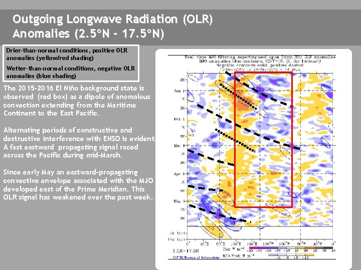
Outgoing Longwave Radiation (OLR) Anomalies (2. 5ºN - 17. 5ºN) Drier-than-normal conditions, positive OLR anomalies (yellow/red shading) Wetter-than-normal conditions, negative OLR anomalies (blue shading) The 2015 -2016 El Niño background state is observed (red box) as a dipole of anomalous convection extending from the Maritime Continent to the East Pacific. Alternating periods of constructive and destructive interference with ENSO is evident. A fast eastward propagating signal raced across the Pacific during mid-March. Since early May an eastward-propagating convective envelope associated with the MJO developed east of the Prime Meridian. This OLR signal has weakened over the past week.

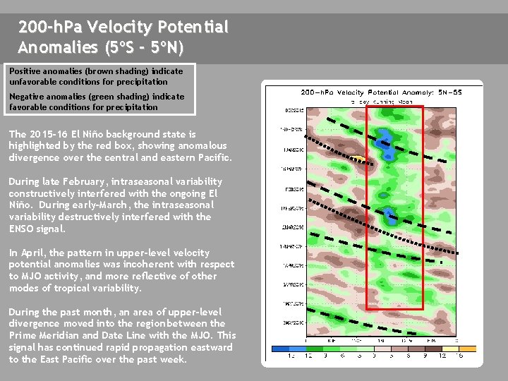
200 -h. Pa Velocity Potential Anomalies (5ºS - 5ºN) Positive anomalies (brown shading) indicate unfavorable conditions for precipitation Negative anomalies (green shading) indicate favorable conditions for precipitation The 2015 -16 El Niño background state is highlighted by the red box, showing anomalous divergence over the central and eastern Pacific. During late February, intraseasonal variability constructively interfered with the ongoing El Niño. During early-March, the intraseasonal variability destructively interfered with the ENSO signal. In April, the pattern in upper-level velocity potential anomalies was incoherent with respect to MJO activity, and more reflective of other modes of tropical variability. During the past month, an area of upper-level divergence moved into the region between the Prime Meridian and Date Line with the MJO. This signal has continued rapid propagation eastward to the East Pacific over the past week.

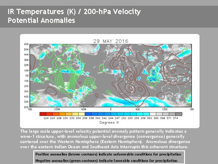
IR Temperatures (K) / 200 -h. Pa Velocity Potential Anomalies The large scale upper-level velocity potential anomaly pattern generally indicates a wave-1 structure, with anomalous upper-level divergence (convergence) generally centered over the Western Hemisphere (Eastern Hemisphere). Anomalous divergence over the eastern Indian Ocean and Southeast Asia interrupts this coherent structure. Positive anomalies (brown contours) indicate unfavorable conditions for precipitation Negative anomalies (green contours) indicate favorable conditions for precipitation

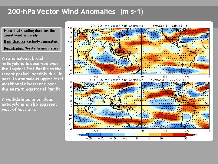
200 -h. Pa Vector Wind Anomalies (m s-1) Note that shading denotes the zonal wind anomaly A Blue shades: Easterly anomalies Red shades: Westerly anomalies A An anomalous, broad anticyclone is observed over the tropical East Pacific in the recent period, possibly due, in part, to anomalous upper-level meridional divergence over the eastern equatorial Pacific. A A well-defined anomalous anticyclone is also apparent west of Australia. A

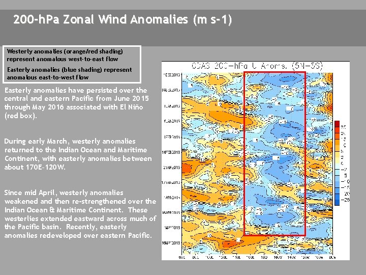
200 -h. Pa Zonal Wind Anomalies (m s-1) Westerly anomalies (orange/red shading) represent anomalous west-to-east flow Easterly anomalies (blue shading) represent anomalous east-to-west flow Easterly anomalies have persisted over the central and eastern Pacific from June 2015 through May 2016 associated with El Niño (red box). During early March, westerly anomalies returned to the Indian Ocean and Maritime Continent, with easterly anomalies between about 170 E– 120 W. Since mid April, westerly anomalies weakened and then re-strengthened over the Indian Ocean & Maritime Continent. These westerlies extended eastward across much of the Pacific basin. Recently, easterly anomalies redeveloped over eastern Pacific.

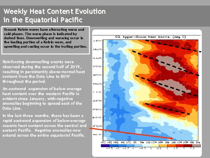
Weekly Heat Content Evolution in the Equatorial Pacific Oceanic Kelvin waves have alternating warm and cold phases. The warm phase is indicated by dashed lines. Downwelling and warming occur in the leading portion of a Kelvin wave, and upwelling and cooling occur in the trailing portion. Reinforcing downwelling events were observed during the second half of 2015, resulting in persistently above-normal heat content from the Date Line to 80 W throughout the period. An eastward expansion of below average heat content over the western Pacific is evident since January, with negative anomalies beginning to spread east of the Date Line. In the last three months, there has been a rapid eastward expansion of below-average oceanic heat content across the central and eastern Pacific. Negative anomalies now extend across the entire equatorial Pacific.

MJO Index -- Information The MJO index illustrated on the next several slides is the CPC version of the Wheeler and Hendon index (2004, hereafter WH 2004). Wheeler M. and H. Hendon, 2004: An All-Season Real-Time Multivariate MJO Index: Development of an Index for Monitoring and Prediction, Monthly Weather Review, 132, 1917 -1932. The methodology is very similar to that described in WH 2004 but does not include the linear removal of ENSO variability associated with a sea surface temperature index. The methodology is consistent with that outlined by the U. S. CLIVAR MJO Working Group. Gottschalck et al. 2010: A Framework for Assessing Operational Madden-Julian Oscillation Forecasts: A CLIVAR MJO Working Group Project, Bull. Amer. Met. Soc. , 91, 1247 -1258. The index is based on a combined Empirical Orthogonal Function (EOF) analysis using fields of near-equatorially-averaged 850 -h. Pa and 200 -h. Pa zonal wind and outgoing longwave radiation (OLR).

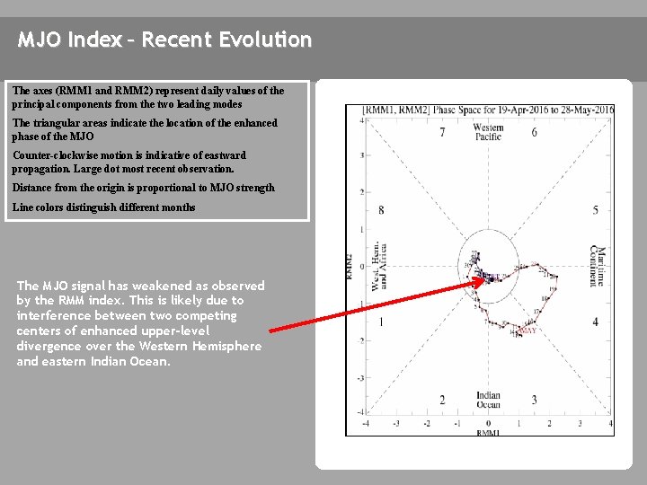
MJO Index – Recent Evolution The axes (RMM 1 and RMM 2) represent daily values of the principal components from the two leading modes The triangular areas indicate the location of the enhanced phase of the MJO Counter-clockwise motion is indicative of eastward propagation. Large dot most recent observation. Distance from the origin is proportional to MJO strength Line colors distinguish different months The MJO signal has weakened as observed by the RMM index. This is likely due to interference between two competing centers of enhanced upper-level divergence over the Western Hemisphere and eastern Indian Ocean.

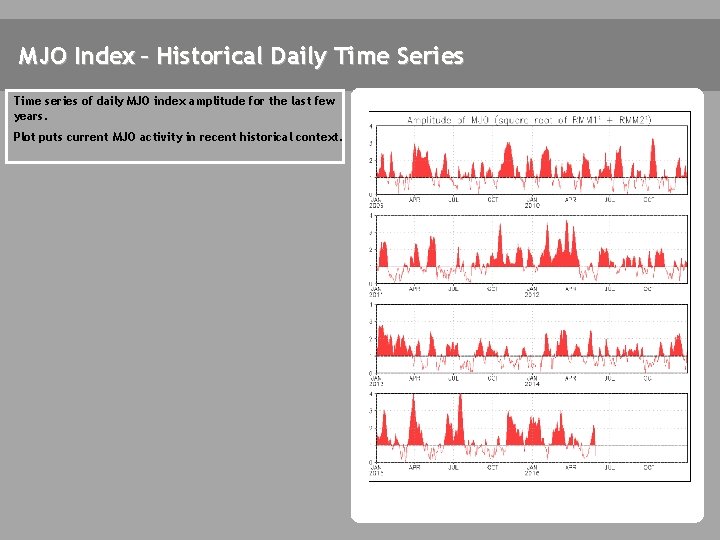
MJO Index – Historical Daily Time Series Time series of daily MJO index amplitude for the last few years. Plot puts current MJO activity in recent historical context.

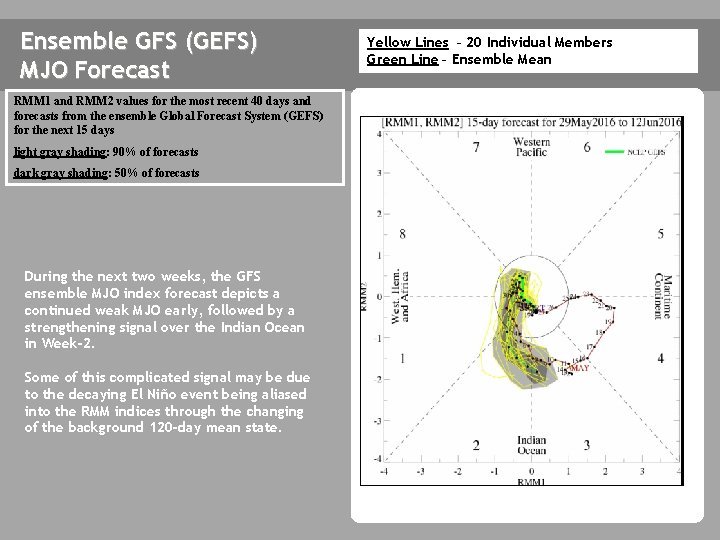
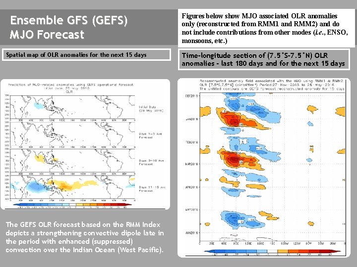
Ensemble GFS (GEFS) MJO Forecast RMM 1 and RMM 2 values for the most recent 40 days and forecasts from the ensemble Global Forecast System (GEFS) for the next 15 days light gray shading: 90% of forecasts dark gray shading: 50% of forecasts During the next two weeks, the GFS ensemble MJO index forecast depicts a continued weak MJO early, followed by a strengthening signal over the Indian Ocean in Week-2. Some of this complicated signal may be due to the decaying El Niño event being aliased into the RMM indices through the changing of the background 120 -day mean state. Yellow Lines – 20 Individual Members Green Line – Ensemble Mean

Ensemble GFS (GEFS) MJO Forecast Spatial map of OLR anomalies for the next 15 days The GEFS plot of MJO related OLR anomalies is unavailable at this time. The GEFS OLR forecast based on the RMM Index depicts a strengthening convective dipole late in the period with enhanced (suppressed) convection over the Indian Ocean (West Pacific). Figures below show MJO associated OLR anomalies only (reconstructed from RMM 1 and RMM 2) and do not include contributions from other modes (i. e. , ENSO, monsoons, etc. ) Time-longitude section of (7. 5°S-7. 5°N) OLR anomalies - last 180 days and for the next 15 days The GEFS plot of MJO related OLR anomalies is unavailable at this time.

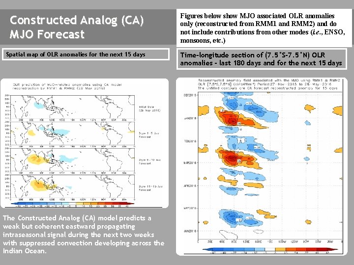
Constructed Analog (CA) MJO Forecast Figures below show MJO associated OLR anomalies only (reconstructed from RMM 1 and RMM 2) and do not include contributions from other modes (i. e. , ENSO, monsoons, etc. ) Spatial map of OLR anomalies for the next 15 days Time-longitude section of (7. 5°S-7. 5°N) OLR anomalies - last 180 days and for the next 15 days The Constructed Analog (CA) model predicts a weak but coherent eastward propagating intraseasonal signal during the next two weeks with suppressed convection developing across the Indian Ocean.

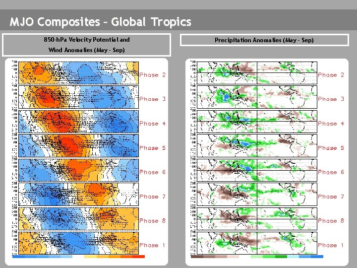
MJO Composites – Global Tropics 850 -h. Pa Velocity Potential and Wind Anomalies (May - Sep) Precipitation Anomalies (May - Sep)

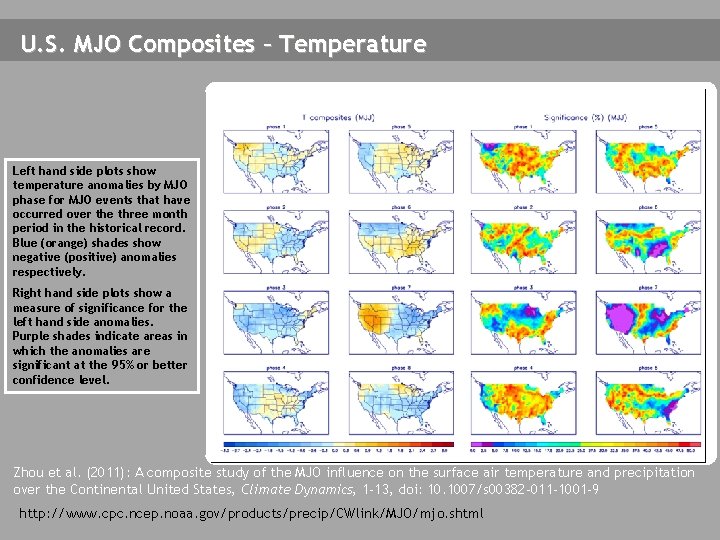
U. S. MJO Composites – Temperature Left hand side plots show temperature anomalies by MJO phase for MJO events that have occurred over the three month period in the historical record. Blue (orange) shades show negative (positive) anomalies respectively. Right hand side plots show a measure of significance for the left hand side anomalies. Purple shades indicate areas in which the anomalies are significant at the 95% or better confidence level. Zhou et al. (2011): A composite study of the MJO influence on the surface air temperature and precipitation over the Continental United States, Climate Dynamics, 1 -13, doi: 10. 1007/s 00382 -011 -1001 -9 http: //www. cpc. ncep. noaa. gov/products/precip/CWlink/MJO/mjo. shtml

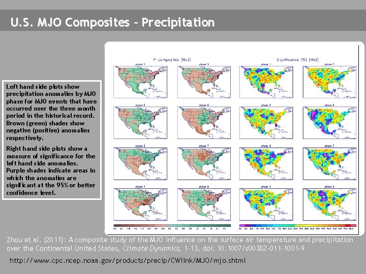
U. S. MJO Composites – Precipitation Left hand side plots show precipitation anomalies by MJO phase for MJO events that have occurred over the three month period in the historical record. Brown (green) shades show negative (positive) anomalies respectively. Right hand side plots show a measure of significance for the left hand side anomalies. Purple shades indicate areas in which the anomalies are significant at the 95% or better confidence level. Zhou et al. (2011): A composite study of the MJO influence on the surface air temperature and precipitation over the Continental United States, Climate Dynamics, 1 -13, doi: 10. 1007/s 00382 -011 -1001 -9 http: //www. cpc. ncep. noaa. gov/products/precip/CWlink/MJO/mjo. shtml