Luca Lodatti Veneto Region Mauro Varotto University of


 2. a Promotion,")


 Detailed Map of terraces in the study area")
 Examined documents: - Austrian Cadastre - 1830 - Present")


- Slides: 32
Luca Lodatti - Veneto Region Mauro Varotto - University of Padua THE ALPTER PROJECT: MIDDLE LANDSCAPES, FROM PROBLEM TO RESOURCE
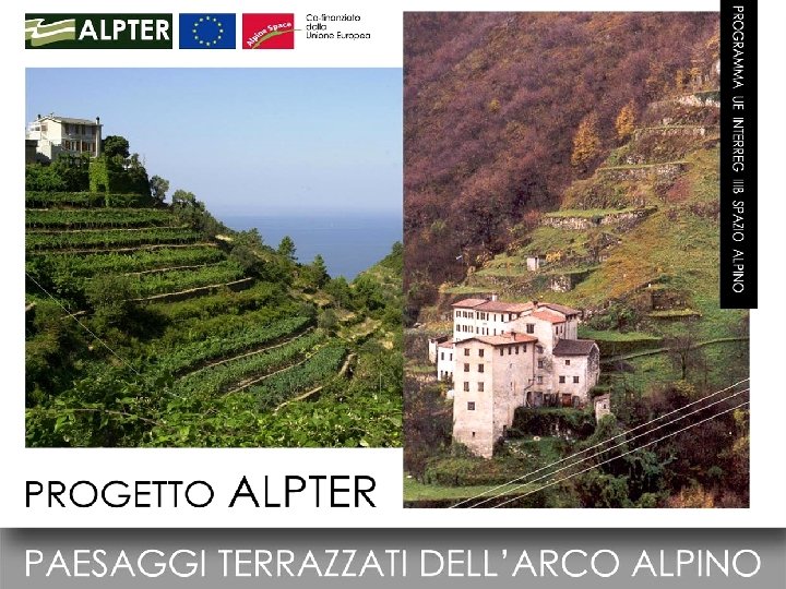
PROJECT ALPTER – TERRACED LANDSCAPES OF THE ALPINE ARC INTERREG III B Alpine Space is an initiative that aims at promoting interregional cooperation in the European Union (period 2000 -2006). It is co-financed in the framework of the European Fund for Regional development. PROJECT ‘ALPTER’ - www. alpter. net A project for study and restoration of the terraced agricultural areas in the Alps. Aimed at enlarging the territorial knowledge, developing tools for promotion of disfavored areas and hazard. Some results : • A common method for the analysis of terraced sites. • A network linking different experiences of study and recovery in EU terraced areas. • Integrated projects of recovery and revitalization of terraced abandoned areas. Partnership: Regione Veneto (Lead Partner) Regione Liguria (I) Regione Valle d’Aosta (I) IREALP (Sondrio - I) Universität BOKU (Vienna - A) University of Ljublijana (SLO) Dep. Alps Maritimes (F) Regione Bregaglia (CH) In collaboration wirh UNESCO
ALPTER Project Study Areas
TERRACED LANDSCAPES AS “MIDDLE LANDSCAPES” q Terraced sites are among the most significant (and fragile) semi-natural habitats, a combination of natural and cultural heritage. q They are based on anthropic equilibrium, which requires human inputs in order to be kept. q Their intermediacy regards also different fields, like social, environmental and economical aspects private property social values community artificial spaces environmental values natural environments monoculture economic values self-sustainment agriculture
TERRACED LANDSCAPES as „MIDDLE LANDSCAPES“ with regard to NATURE and ENVIRONMENT: Natural Wilderness Biodiversity Artificial Intensive cultivation Monoculture Semi-natural habitat High-biodiversity agriculture M. C. Escher, Day and Night, 1938
TERRACED LANDSCAPES as „MIDDLE LANDSCAPES“ with regard to SOCIETY and SIMBOLIC VALUES: Private Individual Authonomy Public Collective Interdependence Semi-private Collective works M. C. Escher, Day and Night, 1938
TERRACED LANDSCAPES as „MIDDLE LANDSCAPES” with regard to ECONOMY and PRODUCTION : Subsistence Economy Polycolture Hand techniques Modern monofunctionality Monoculture Mechanization Multifunctionality Modern polycolture M. C. Escher, Day and Night, 1938
The many threats to terraced landscapes The ‘Middle landscapes’ are threatened by all the processes towards opposite extremes:
Threats to terraced landscapes The Productivity Diktat
Threats to terraced landscapes The Urban Sprawl
Threats to terraced landscapes Abandonment and Wilderness
Intermediacy as a value of ‘middle landscapes’ The environmental and economical balance between the opposite extremes is a value: recognizing this character of the terraced landscapes means recognizing their importance. The terraced landscapes are a balanced setting at various levels: environmentally (man/nature), socially (private/common), economically (production/sustenance) They are a historical example of what is nowadays called ‘Sustainable land management’ After recognizing their value, the necessity of supporting them emerges from local and international subjects
NEW ATTENTION FOR THE TERRACED LANDSCAPES (Earth Summit Rio 1992 – Agenda 21, cap. 34) 1987 -2008: SPSSocietéinternationale pour l’etude de la Pierre Sèche - Drystone Walling Congress • 1997: ONU Programme against desertification • 1998: IPOGEA (UNESCO) • 1999: ‘Cinque Terre’ in the World Heritage • 2000: European PATTER Project • 2001: White Book of Italian Touring Club (Un paese spaesato) • 2003: PROTERRA (Swiss Found. for Landscape Prot. ) • 2004: TERRISC Project • 2005: ALPTER Project • 2005: REPS Project • Specific research programmes (IT: AGEI, IMONT, SIGEA) • Eco-museums of terraces (Cortemilia, Valstagna)
The strategy of the ALPTER Project 1. Knowledge (Inventory, Mapping, Analysis) 2. a Promotion, not protection (active use vs ‘monumentalization’) 2. b Promotion strategies: • Productive recovery • Tourist promotion • Enhancement of social value
Example of activities of the ALPTER Project Research and policies in Veneto
BRENTA RIVER VALLEY, VENETO, ABOUT 1950
ALPTER Project Study Areas
WORKERS IN A TOBACCO FIELD
EXAMPLE OF TERRACED LANDSCAPE DEVELOPMENT: BRENTA RIVER VALLEY, MID ’ 70 s
EXAMPLE OF TERRACED LANDSCAPE DEVELOPMENT: BRENTA RIVER VALLEY, 2006
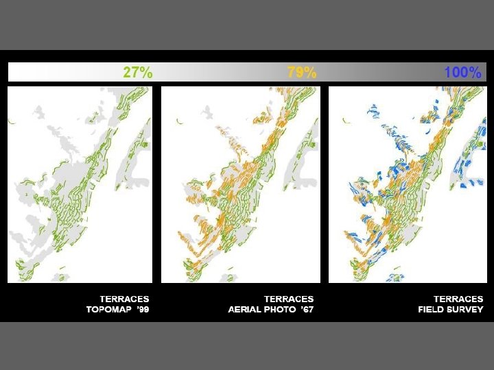
ALPTER Analysis activities (2005 - 2007) Detailed Map of terraces in the study area (scala 1: 25000) Work steps Start: Official Regional Topomap 1 st step: Aerial photos (1967) 2 st step: Survey on the ground Elaboration: University of Venice Results: Cartographic base the local Municipalities and the planners
Historical cadastre (scale 1: 25000) Examined documents: - Austrian Cadastre - 1830 - Present Cadastre - 1990 Elaboration: Univ. of Padua State Archive of Bassano On the right, comparison between land uses: - Land use in 1830 - Land use in 1960 - Present time (aerial photos) Terrazzamenti a orti Bosco Prato Edifici Bosco Non disponibile Pascolomisto 2000 Incolto Edifici Non disponibile 1834 1960
Data sheets Common format to all the ALPTER project areas Data collection for 17 sites
Projects for management of some sites, in collaboration with the local Municipalities
Example of restoration and management project : Mattietti and 22 Hours Hill Higher settlement - Presently abandoned Linking path - Well preserved Planning and design foreseeing sustainable technologies: - Solare panels - Water collection systems - Passive buildings - Monorail Lower settlement - Inhabited The higher part of the settlement has been conceived as self-sufficient
New Master Plan of the Valley Guidelines for landscape management With the support of the local administrations and of the planners, a classification of different typologies of terraced areas and related guidelines have been included in the new Master Plan
Establishment of financial support instruments - Proposal for integration of the Regional Rural Development Plan (EU Funds for Agriculture) - Meetings with the regional government for a funding measure for rural landscape - From 2009 to 2013, co-funding opportunities for landscaperelated activities - Promotion strategies: • Productive recovery • Tourist promotion • Enhancement of social value
Who can restore and live in this terraced areas? Beside the local inhabitants, this is an area populated by immigrants who works in the plains and rent a house here. Resident population Immigrants/Residents Ratio: Higher than Italian average Immigrants/Residents Ratio for young people
“The stone refused by the builders has become a key stone ”
Thank You! www. alpter. net info@alpter. net