LRTP Alternatives Results 2040 Long Range Transportation Plan


 US 1 Matanzas Woods Map")


- Slides: 14
LRTP Alternatives Results 2040 Long Range Transportation Plan for River to Sea TPO Board Meeting May 27, 2015
OVERVIEW v Two alternative scenarios and their corresponding project lists were presented to your committee last month Ø Highway Only with Trends Land Use Ø Transit Alternative with Transit Alternative Land Use (also includes all Highway improvements) v Model runs have since been prepared and results presented to the LRTP Sub-Committee on May 8, 2015 v The findings are being shown to you today
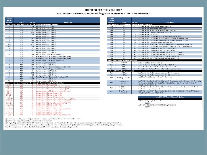
Transit Alternative v v aka Alternative Land Use Scenario All roadways included in the Highway Only Alternative Existing route service enhancements and new transit routes Input utilized to develop transit enhancements: Ø Ø Ø 2035 LRTP Mass Transit project list Ø Transit service added along SR A 1 A and US 1 to provide connections between Flagler and Volusia counties Votran’s adopted Transit Development Plan (TDP) projects list Sustainable Development Corridors as identified in the adopted Alternative Land Use Scenario (Characterization Framework Map)
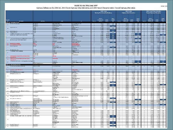
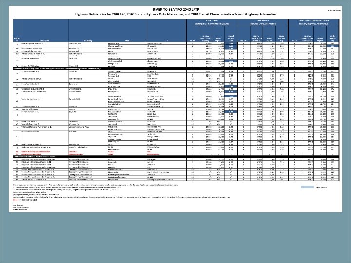
Highway Only Alternative v v aka Transportation Trend Scenario Roadway Improvements Only Ø Ø v Roadway Widenings New Extensions Input utilized to develop improvement list: Ø Strategic Intermodal System (SIS), Other Arterial Projects and Projects per Stakeholders Input Ø Volusia County’s Public Works Strategic Roadway Plan (unfunded priority corridor improvements) projects list Ø Farmton DRI developer funded projects list
CR 13 2010 Base Yr Transit (North TPO Area) US 1 Matanzas Woods Map 1 SR A A 1 erre Belle T Pkwy d gs R Kin d l O Palm Coast Pkwy Royal Palms Pkwy SR 20/SR 100 SR 11 e ol in s m d Se oo W 4 30 CR CR 305 I-95 US 1 d Han Ave SR 40 17 LPGA Blvd US Transit routes Roadways
SR A 1 A Clyd e Mo rris Map 2 line Made W US US 17 ill 92 SR 4 21 ia m so n Kepler Ai rp or t I-4 2010 Base Yr Transit (South TPO Area) Plymouth SR 44 nbu ll B rl r. T ay e ne Pio Tur Beresford ve k. A Par Orange Camp SR 47 2 se pri ter En xo en Dirks No n 41 Blv SR 442 SR 44 nd SR Sa 5 wla Providence Ho d rm an d y Doy le US 1 Osteen-Maytown Rd Transit routes Roadways
Map 3 Rd K Old Belle ings 1 A e Terr Palm Coast Pkwy A SR CR 13 2040 Transit Alt. (North TPO Area) US 1 Matanzas Woods SR 100 30 I-95 CR US 1 -9 2 92 17 e Av nn Du US er C b Tym /U S LPGA Blvd 15 rris Mo de son liam Wil SR d Han Ave Cly SR 40 reek Airp ort R d CR 305 4 SR 11 W Se m oo ino ds le Commerce Pkwy Royal Palms Pkwy SR 20/SR 100 Transit routes Roadways
A rris on ms US US 92 d R or l ay 17 T 1/ Kepler Plymouth er ne SR 44 Pio Trl Ai rp or t 42 Turnbull Bay 15 SR 4 y Do Roadways n Ext liamso A ial ter Ar yle wy/Wil Co u rm an d g Pk Deerin nd n rtla xo nce an ’s ter Ve SR 442 d am Sa Blv Osteen-Maytown Rd Transit routes ve I-95 rise en Dirks nd Provide Kentucky Ho Rhode Isl Elk c No h St Tent k. A Par wla Saxon erp SR Orange Camp SR 47 2 Ent 44 Westside Pkwy P Av Mis e ge ai Beresford n CR I-4 N. Entrance to De. Land Airport sio 2040 Transit Alt (South TPO Area) A 1 e Mo llia Map 4 SR Clyd Wi Madeline
Map 11 Matanzas Woods Palm Coast Pkwy K Old Commerce Pkwy R ings d 2040 Hwy Alt. Improvements (North TPO Area) SR 100 I-95 1 Ai rp or t. R d U S ber C Tym Ave GA LP s ri or e. M yd Dunn Ave 17 d Blv Cl US son liam Wil SR 40 reek d Han US 92
US 17 e Mo Clyd rris m llia Wi son Map 12 2040 Hwy Alt. Improvements (South TPO Area) US 92 d r. R Ta I-4 N. Entrance to De. Land Airport o yl t or rp Ai Plymouth Kepler sio n Av Mis wla t th S Ten ve Ext d m liamson ra n’ lan urt n rm an d y Do l. A ria te Ar yle Osteen-Maytown Rd I-95 e s pri xo Co Ve te SR 442 ha Sa No nd Pkwy/Wil Ho Deering 47 2 Rhode Isl Elk c ter D n irkse e e ig k. A Par Kentucky SR En Saxon Trl Pa s Westside Pkwy -92 US 17 Beresford er ne Pio
CONTACT INFORMATION Martha Moore, PE Ghyabi & Associates, Inc. 904. 396. 5727 Jean Parlow River to Sea TPO 386. 226. 0422 Ext. 20417 Scot Leftwich, PE Leftwich Consulting Engineers, Inc. 407. 281. 8100