LOCATION INTELLIGENCE Any time Any place Any how


 standards-based support for Web services • • Web")


 –")


 • Via addressing and business lists")


 locations, demographic characteristics • Identify")
 areas with high mortgage costs to")

 l Customer complaints")


- Slides: 55
LOCATION INTELLIGENCE Any time, Any place, Any how Matti Seikkula Barry Hodges Chief Information Officer, e-Spatial Senior Solution Architect, Oracle
Agenda • • Introduction to geospatial Integrated Oracle products Geospatial Standards Geospatial Data Cleansing, Geocoding and Certifying Addresses Raster and Globe Technologies Location Intelligence
Demand Generation “TV viewers' average hits 50” Source: http: //www. variety. com/VR 1117988273. html
What is Location Data? • Think “anything connected to a physical location” • Business data that contains or describes location – – Street / postal address (customers, stores, factories. . . ) Sales data (sales territory, customer registration…) Assets (cell towers, fire hydrants, electric transformers. . . ) Geographic features (roads, rivers, parks. . . ) • Practically every database in the world contains some form of business data that can be leveraged using spatial technologies • Location is a “universal key”
Location Data in your Application Information Type Location-enabled Use • Address Ÿ Report & Map Location, Proximity & Interaction Relationships • Routes, Utility, infrastructure, etc. Ÿ Develop Routes / Trace & Manage Field Assets • Administrative areas (post code, tax, county, area code, real estate, sales territories, mesh blocks etc. ) Ÿ Summarise, Compare, Drill Down Analytics, Track Assets etc.
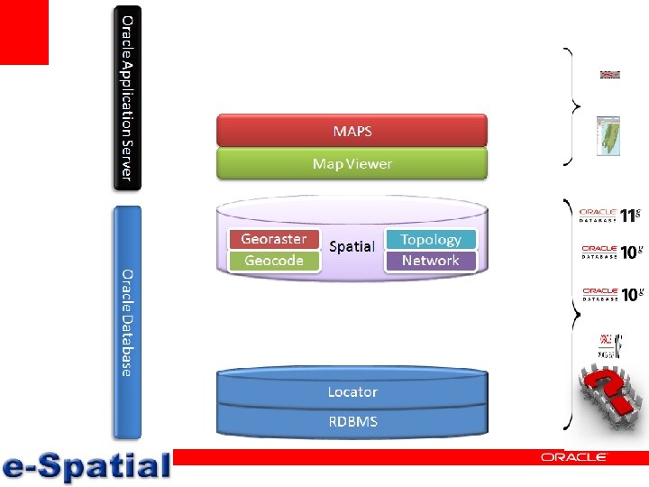
Key Technologies Data Manage commercial and customer geospatial data Geocode Convert addresses into coordinates Analyze Find Proximity, Location, Containment Display Add Maps & Reports to your Application
Oracle Locator Included in Oracle Database ALL Editions Support for all geometry types • 2 D data support • All Spatial Operators • Distance and validation functions • Full Coordinate Systems support • Utility & tuning packages • Long Transactions • Parallel spatial query & index builds • Table Partitioning • Object Replication
Oracle Locator Included in Oracle Database ALL Editions Support for all geometry types • 2 D data support • All Spatial Operators • Distance and validation functions • Full Coordinate Systems support • Utility & tuning packages • Long Transactions • Parallel spatial query & index builds • Table Partitioning • Object Replication Oracle Spatial 11 g Priced option for Oracle Database Enterprise Edition • Includes all Locator features • Additional Spatial Functions - area/length calculation - buffer, centroid, union, etc • • • Linear Referencing Support Spatial Aggregates Geo. Raster Data Type Topology Data Model Network Data Model Geocoder Engine Spatial Analytical Functions 3 D Support OGC Web Services - Web Feature Server - Web Catalog Server
Oracle Map Viewer • Included in every Oracle Application Server edition • Integrated with – Oracle JDeveloper – Oracle Business Activity Monitoring – Oracle Web. Center – Oracle Business Intelligence Enterprise Edition • Standards-based J 2 EE and Java Server Faces component – XML/HTTP, Java/AJAX – Runs in J 2 EE containers and Java IDEs • Publish spatial data to the web • Map and feature cache provides smooth scroll (pan, zoom) • Rich Java, XML, Java. Script APIs provide client side interactivity • Centrally managed map definitions, symbology, and styling rules
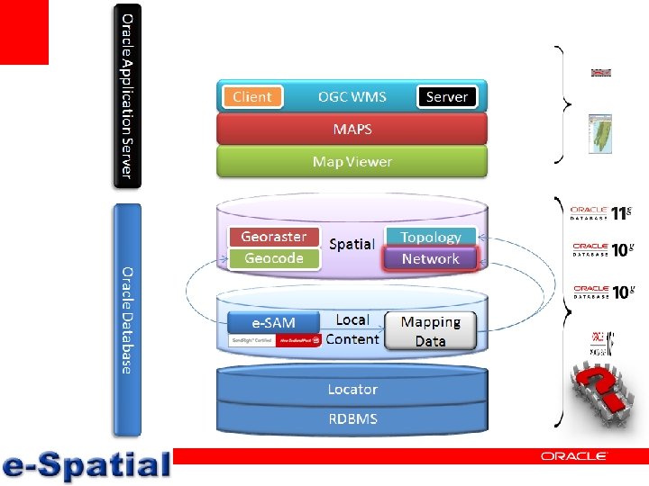
• • • Oracle partner since 1998 Specializing in geospatial niche Spatial data modeling, analysis and mining Spatial design, development and integration Address (bulk) cleansing, geocoding and certification Geospatial strategies and standards • e-SAM address model product • Vue. NZ hosted imagery service
Oracle Database – Are you aware? • Do you use Oracle 8 i or later? – – Spatial has been part of Oracle since 8. 1. 5 (almost 10 years) There is a free version of Oracle geospatial called Locator is inside all instances of Oracle including XE Every geospatial vendor product supports Oracle – Some new 11 g locator features: – Function for buffering points, lines and polygons – Functions for distance, area and length – Support for SQL/MM ISO standard – Partitioning spatial indices • Oracle holds 80 -90% or spatial database market: • http: //www. geoconnexion. com/uploads/consolidate_ukv 6 i 2. pdf
Application Server – Are you aware? • Do you use Application Server 9 i. AS or later? – – – Map Viewer has been a hidden feature for 6 years It is J 2 EE (Java), free, commercial strength mapping engine It complies with OGC (e-Government) standards e. g. WMS It is included on all instances of the application server It includes a rich Map Manager tool for configuring the maps There a lot of example code enabling applets, servlets and web services to get you started • Oracle MAPS - AJAX implementation of Map Viewer – Google Maps type solution using map tiling services • GE Small. World chooses Map Viewer: http: //www. geoinformatics. com/asp/default. asp? t=article&zoek 1=oracle%20 fusion&newsid=3612
They are Aware!
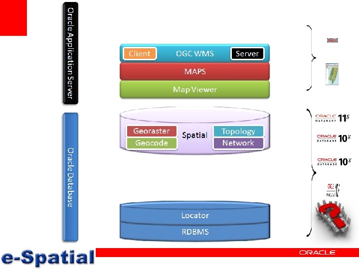
Standards Compliance Open Geospatial Consortium (OGC) standards-based support for Web services • • Web Mapping Service (client and server) Open. LS (Mapping, Geocoding, Routing) Catalogue Service (Registry) Web Feature Service (WFS-T ) SOAP & XML interfaces for all web services Simple Features for SQL (WKT/WKB) Geography Markup Language (GML)
Support for OGC Web Services Open Location Service
Geo-spatial data – definition • 2 D vector data (X and Y coordinates) – Resolution is already good enough – Issues with road network, GPS vs survey data • 3 D vector data (Z coordinate) – Huge increase in data size – Points are easy, polygons are huge made of grid • Time series (M coordinate) – Increase in data size to 4 th dimension • Raster data (aerial and satellite imagery) – 50 cm pixels now, 10 cm and even 4 cm – In future this reference data will grow exponentially
Geospatial data and where to get it? New Zealand Datasets Supplier Type Cost Access NZ Fire Service Suburbs, Towns, Cities No Request Statistics NZ Census Mesh Blocks No Web Site GPS Street Maps Roads, Supermarkets, Petrol Stations, Speed Cameras, Schools No Web Site LINZ Cadastral data: Addresses, land parcels, title, roads, legalities No Request LINZ Topographic data: Hydro, buildings, contours, formed roads Yes Request NZ Postal Address File & Geo. PAF Yes Request e-Spatial ESAM (Address Database) Yes Request NZ Defense Force Kiw. Image satellite imagery Yes Request QV & e-Spatial Hosted Imagery Service Yes Request
Importing Geospatial Data to Oracle • External GIS vendor upload tools – Mapinfo, ESRI, Intergraph. . . • Shape to SDO command – shp 2 sdo. exe C 96 MB c 96 mb -g geoloc -d -x (-180, 180) -y (-90, 90) s 8307 -t 0. 5 –vspatial – sqlplus matti/passwd @c 96 mb. sql – CHARACTERSET EL 8 ISO 8859 P 7 BYTEORDER LITTLE – sqlldr name/passwd control shapefile_name. ctl • Loading WKT or WKB – insert into C 96 MB (ID, GEOLOC) values (1, SDO_UTIL. FROM_WKTGEOMETRY('MULTIPOLYGON (((3330000. 0 5440000. 0, 3550000. 0 5550000. 0, 3330000. 0 5440000. 0)))', 31467));
Analyze: Geospatial Data Find all competitors within 2 kilometres of Northport Branch SELECT c. holding_company, c. location FROM competitor c, bank b WHERE b. site_id = 1604 AND SDO_WITHIN_DISTANCE(c. location, b. location, 'distance=2 unit=km') = 'TRUE' Map data © NAVTEQ
Key Technologies – e-SAM Data e-SAM data and other local datasets Geocode Managed and enabled by e-SAM Analyze Accessed via e-SAM stored procedures
Local content – e-SAM • • Local address model within oracle database Functionality enabled via stored procedures NZ Post Send. Right certified Cleanse, geocode and certify customer addresses Not a black-box solution, flexible, easily integrated In-use postal and LINZ legal addresses included Uses known places, emergency services accepted localities and city/towns, NZ Post postcodes
e-SAM Diagram
Addressing Issues – Vanity Addresses LEGAL vs POSTAL CORNER OF ADDRESSES I live at 40 Otaki Street I’m number one!
Addressing Issues – Adjacent Localities NEIGHBOURING CITY VANITY SUBURB I’m an Aucklander! I live in Khandallah
Addressing Issues – Rural Delights RURAL DELIVERY TOWN vs MAIL TOWN But my RD is 4? I Live in Otorohanga
Addressing Issues – Urban Delights COMPOSITES Where do I live? SUBURB MIX-UPS I live in Beckenham
Addressing Issues – Aliases, aliases … RENUMBERING ROADS DISCONNECTED ROADS
Addressing Issues – Aliases, aliases … TOURISM ROAD NAMES LOCAL STATE HIGHWAYS
Addressing Issues – Aliases, aliases … KNOWN LOCALITIES And this was just the tip of the iceberg!
Demonstration – e-SAM • Send. Right certifier too
Key Technologies – Map Viewer Data Manage commercial and customer geospatial data Geocode Convert addresses into coordinates Analyze Find Proximity, Location, Containment Display Add Maps & Reports to your Application
Map Viewer – Layer Control Customer data (transactions) • Via addressing and business lists Generic mapping layers • 100+ layers? Vector and raster Demographics and cluster data • Census and mosaics • Sales territories & data Build the complete picture • Layer order is relevant
Map Viewer – Layer & Style Management
Location Intelligence – Sales territories Marketing areas defined Targeted marketing by local knowledge Tying to demographics
Location Intelligence - Buffering
Location Intelligence – Risk Factors
Location Intelligence - Portals
Location Intelligence – Site Analysis • Examine sitelocations, (competitor) locations, demographic characteristics • Identify areas worthy of expansion / determine market share
Location Intelligence - Segmentation • Identify (post code) areas with high mortgage costs to target advertising campaign on refinancing offerings
Location Intelligence – Targeted Marketing • Find customers within several kms of a new branch / ATM location – targeted mailing on banking options • Identify customer base and market area that provide greatest revenue
Location Intelligence – Targeted Marketing Good customers (based on annual sales) l Customer complaints included l
Location Intelligence - Transactions l Showing transactions as a point layer l Displaying deprivation index using Census data l Result: there seems to be a correlation between transactions and socioeconomic
Location Intelligence – Hot Spotting l When you have a lot of transactions occurring on same locations l Just showing a point does not reflect this as all transaction points on top of each other l Hot spotting shows a colour-coded (hot-tocold) layer underneath transaction points
Location Intelligence – High density l With good high density mapping you do not necessarily even need to show the transactions
Location Intelligence – Customer Penetration Where are our competitors – distance bands around the retail outlet and competitors shown l How wealthy is the neighbourhood average income per household from Census data. l Where do 50% and 80% of our customers come from? l
Location Intelligence – Unemployment
Location Intelligence – Value of 3 D l Sometimes 2 dimensions does not really show the demographics that well
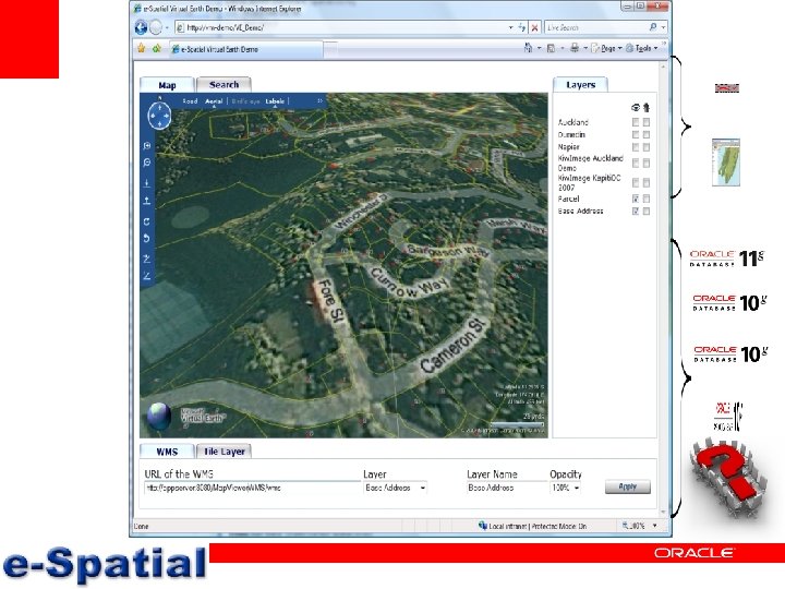
Demonstration – Vue. NZ and Globe Technology
For more information • Matti Seikkula, Chief Information Officer – – • Andrew Lee, Business Development Manager – – • Email andrew@e-spatial. co. nz Mobile 027 566 5000 Shane Turk, Data Manager – – • Email matti@e-spatial. co. nz Mobile 027 566 5625 Email shane@e-spatial. co. nz Mobile 027 535 5756 e-Spatial Limited – Level 1, Petherick Tower – – 38 Waring Taylor Street, Wellington 6011 Phone 04 499 3546, Fax 04 499 3547 – www. e-spatial. co. nz