Light Detection and RangingLIDAR BY SONU SANGAM USN1
 BY: SONU SANGAM USN-1 C 07 EC 096 BRANCH-ECE SEM")
Light Detection and Ranging(LIDAR) BY: SONU SANGAM USN-1 C 07 EC 096 BRANCH-ECE SEM -VIII

INTRODUCTION What is LIDAR ? v. Remote sensing technology v. Uses much shorter wavelength of EM spectrum v. Measures properties of scattered light v. Measures time delay between transmitted and reflected signals v. Highly sensitive to aerosols and cloud particles

General Description LIDAR vs RADAR v. LIDAR uses much shorter wavelength of UV, visible and near IR range v. LIDAR is highly sensitive to non-metallic objects v. LIDAR has very narrow beam which produces high resolution

LIDAR TYPES v based on backscattering : Ø Rayleigh LIDAR Ø Mie LIDAR Ø Raman LIDAR Other types: Ø Coherent LIDAR(phase sensitive) Ø Incoherent LIDAR(amplitude measurement)
 They are:")
TECHNOLOGIES USED v. Integration Of three technologies to produce Digital Elevation Models(DEM) They are: Ø Lasers Ø Global Positioning System(GPS) Ø Inertial Navigation System(INS)

WORKING v. Laser produces optical pulse v. Pulse is transmitted , reflected and returned to the receiver v. Receivers accurately measures the travel time v. X, Y, Z ground coordinates can be calculated using : Ø Laser range Ø Laser scan angle Ø Laser Position from GPS Ø Laser orientation from INS

COMPONENTS v. Laser: Ø 600 -1000 nm lasers used for non-scientific application § Inexpensive § Easily absorbed by eye Ø 1500 nm lasers § less advanced, longer range , lower accuracy § Eye safe at much higher power level § Used in military application

Contd…. . v. Scanner Ø Used to scan the objects , azimuth and elevation Ø Uses : § Dual oscillating plane mirror § Combination of polygon mirror § Dual axis scanner v. Optics Ø They affect angular resolution and range Ø To Collect return signal it uses : § Hole mirror § Beam splitter

Contd…. . v. Photo detector and receiver electronic Ø Solid state photo detectors Ø Silicon avalanche photodiodes v. Position and navigation systems Ø Global Positioning System receiver Ø Inertial Measurement Unit(IMU)

APPLICATIONS v. LIDAR-equipped mobile robot Ø Used for constructing map and avoid obstacle

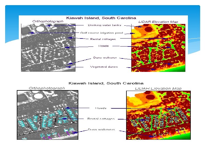
Contd…. ARCHAEOLOGY v. Creates high resolution Digital Elevation Models v. Aiding in planning of field campaigns and forest canopy v. Provides an overview of broad continuous indistinguishable feature GEOLOGY v. Aircraft based LIDAR Ø Detect fault and measure uplift Ø Monitors glaciers

Contd…. Meteorology and Atmospheric Environment v. Used for studies of atmospherics conditions , structures , clouds and aerosols. v. Used for measurement of atm. gas v. Used for measuring the concentration of atm. gases v. Measures wind speed

Contd…. PHYSICS AND ASTRONOMY v. Measure the distance to reflectors placed on the moon v. Used in Mars-Orbiting Satellite to produce precise global topographic survey of Mars v. Used to detect snow in Mars atmosphere v. Used to measure molecular density

Contd…. MILITARY AND LAW ENFORCEMENT v. Used in traffic speed enforcement for vehicle speed measurement v. Uses the principle of time of flight to calculate speed v. Able to find the vehicle speed from cluster traffic situation v. Higher resolution system collect detail to identify targets (tanks)

LIDAR DATA What can we do with LIDAR ? v. Measure distance v. Measure speed v. Measure rotation v. Measure chemical composition and concentration

CAPTURE OF ELEVATION POINTS v. Collects only elevation data v. GPS antenna is mounted on upper fuselage v. GPS sensors records the data v. Data are downloaded and processed v. X, Y, Z coordinates are found

OTHER APPLICATIONS FLOOD RISK MAPPING v. Quickest and most accurate method to measure DEM v. Easy flood prediction and plan mitigation and remediation strategies

Contd…. OIL & GAS EXPLORATION SURVEYS v. Provide high speed data acquisition and limit ground intervention v. Done using either a fixed wing or helicopter mounted LIDAR system

Contd…. ENGINEERING/CONSTRUCTION SURVEY v. Using DEM cut and fill quantities can be more precisely estimated v. Time delay between data acquisition and delivery is very less v. Air bourn LIDAR provide a cost effective and quick surveys for real estate development

Contd…. TRANSMISSION LINE MAPPING v. Calculating power line heights or sag under different loads Ø Inventory Ø Tower Placement Ø Height of underlying vegetation

SHOALS-SPECIFIC APPLICATIONS v. Undersea cable routing v. Wreck detection v. Charting and safety issues

CONCLUSION v. It has allowed data to be collected that was difficult or impossible to obtain prior to its introduction. v. Data collection and its processing is relatively fast v. LIDAR saves clients money v. LIDAR offers flexibility v. LIDAR is unobtrusive and environmentally friendly

REFERENCES vwww. wikipedia. org vwww. lidar. com vwww. ambercore. com vwww. gisdevelopment. net vwww. lidarmap. org vwww. velodyne. com/lidar/

THANK YOU
- Slides: 25