Lidar Point Clouds for Developing Canopy Height Models
 for Bankhead National Forest Plots")

? Remote sensing tool used to measure certain")


 Aerial photo of B")
 Aerial photo of B")


 First Return – Bare")


 Author: Sorin C. Popescu - Texas A&M")


- Slides: 23
Lidar Point Clouds for Developing Canopy Height Models (CHM) for Bankhead National Forest Plots By: Soraya Jean-Pierre REU Program at Alabama A & M University Oakwood University 07/25/08
Background Information The state of Alabama is 71% forest and is this nation’s second largest commercial forest. There is nearly 23 million acres of forested land in Alabama. Different tools have been developed to assist in studies of the forest and LIDAR has proven to be very useful.
What is Light Detection and Ranging (LIDAR)? Remote sensing tool used to measure certain physical characteristics of the forest. Beneficial to foresters that utilize data such as tree heights, wood volume and biomass. Components of a Lidar system include laser scanner, receiver, Airborne GPS and an Inertial Measurement Unit (IMU).
Uses of the Components of LIDAR Systems Scanners are vital because they copy the images into the LIDAR system. Receivers are important for capturing reflections produced by objects. GPS and an IMU are needed to determine the location and orientation of the LIDAR sensor.
How Does a LIDAR System Work? IMU, GPS, and laser scanner are placed on the bottom of an airplane. Lidar system uses pulses of multiple laser light that collide with the target surface. Ground vegetation along with the canopy reflect the laser light, which then returns to the sensor’s receiver.
LIDAR The time it takes for the reflected emitted pulse to return to the receiver is then measured. The ground vegetation, and the canopy produce different time delayed measurements. Accurate measurements of the physical characteristics of forests can be made.
What is CIR? Color infrared imagery is a relatively new tool that provides photos of vegetation. It presents foresters with images that can differentiate between healthy vegetation and stressed vegetation. The accuracy of CIR imagery can also be used to distinguish between various tree species.
Objectives Examine the capabilities of Lidar data in conjunction with CIR imagery to develop Canopy Height Models (CHM) using Arc. Gis Applications.
Treated Plot Areas Nine treatment combinations Four block study areas Each treatment applied to an area 22 ac Block 1 (of 4) Trt 1 Trt 5 Trt 3 Trt 2 Trt 8 Trt 6 Trt 4 Trt 7 Trt 9 created by Dr. Schweitzwer
Study Area and Data William B. Bankhead National Forest (BNF) Aerial photo of B 2 T 6 with specified boundary
Study Area and Data William B. Bankhead National Forest (BNF) Aerial photo of B 2 T 6 with specified boundary
A Model of Procedures Lidar Data Points Clip Data Extract points within Specific boundary Interpolation First Returns Vegetation heights Model Builder Bare Earth Returns Subtracted OK BER Data from OK FR Ground topography CANOPY HEIGHT MODEL
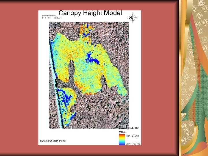
Block 2 Treatment 6
Using Model Builder To Create CHM (B 2 T 6) First Return – Bare Earth Return = Canopy Height Measurement
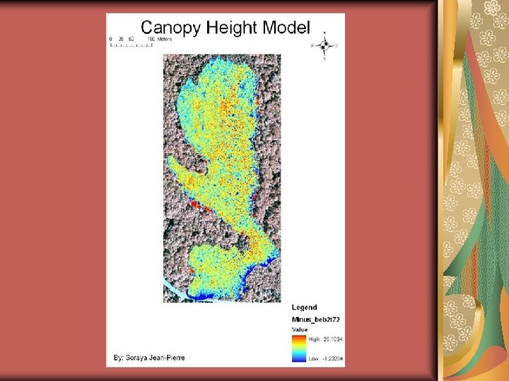
B 2 T 7
Using Model Builder To Create CHM First Return – Bare Earth Return = Canopy Height Measurement
Conclusion Lidar data along with CIR imagery proved to be capable of developing canopy height models. Arc. GIS applications also worked in conjunction with the Lidar data in developing the canopy height model. Further research to be done includes calculating individual tree heights and locations.
Tree Variable Window (Tree. Va. W ©) Author: Sorin C. Popescu - Texas A&M University CHM are processed using IDL software. Input is a LIDARderived CHM into ENVI image format. The output consists of individual tree positions, crown radius, and tree height. Trees can be identified and located based on local maximum filtering technique using continuously varying windows of circular shape.
Acknowledgements n Dr. Wubishet Tadessee and Dawn Lemke n Joe Gardinski and Rick Fields n Dr. Moss and Dr. Wang n Co-PIs Dr. Luben Dimov, and Dr. Callie Schweitzer n REU Colleagues
References M. D. Behera and P. S. Roy. 2 December 2002. Lidar Remote Sensing for Forestry Applications. 10 December 2002 Yungshen Wang, Holger Weinacker and Barbara Koch. 6 June 2008. A Lidar Point Cloud Based Procedure for Vertical Canopy Structure Analysis and 3 D Single Tree Modelling in Forest. 12 June 2008