
Levee and Shoreline Analysis Task Justin Vandever PE


- Slides: 26
Levee and Shoreline Analysis Task Justin Vandever, PE AECOM – Oakland, CA justin. vandever@aecom. com Sarah Kassem, PE AECOM – Oakland, CA sarah. kassem@aecom. com SR 37 Design Alternatives Assessment SR 37 Policy Committee – March 1, 2018
Introduction & Approach Shoreline Analysis Task Goal • Identify potential strategies to mitigate near-term flood risks to SR 37 prior to implementation of the corridor-wide project • Educate stakeholders about near-term flood vulnerabilities along the SR 37 corridor and potential mitigation actions Approach • Identify locations of potential shoreline overtopping for various SLR/storm scenarios • Identify potential for other shoreline deficiencies (erosion, instabilities, seepage) • Develop toolbox of conceptual design strategies • Evaluate applicability of each strategy to different shoreline types • Develop cost estimate to meet different levels of near-term flood protection
What is included in this evaluation? • High level evaluation of levee and shoreline elevations relative to Bay flood levels • Identification of potential flood mitigation strategies to address near-term flood vulnerabilities • Estimation of magnitude and extent of necessary levee and shoreline crest elevation improvements • Rough order of magnitude cost estimate to address levee and shoreline elevation deficiencies along SR 37 corridor
What is NOT included in this evaluation? • Geotechnical evaluation of levee and shoreline condition and stability • Estimation of costs to address potential geotechnical issues • Site-specific engineering design or a specific project recommendation • Estimation of environmental mitigation or land acquisition costs • Assessment of combined riverine-coastal flooding
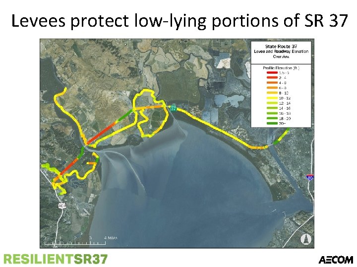
Levees protect low-lying portions of SR 37
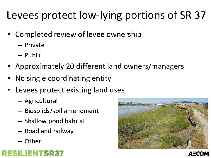
Levees protect low-lying portions of SR 37 • Completed review of levee ownership – Private – Public • Approximately 20 different land owners/managers • No single coordinating entity • Levees protect existing land uses – – – Agricultural Biosolids/soil amendment Shallow pond habitat Road and railway Other
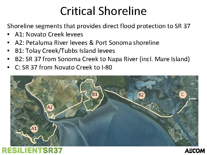
Critical Shoreline segments that provides direct flood protection to SR 37 • A 1: Novato Creek levees • A 2: Petaluma River levees & Port Sonoma shoreline • B 1: Tolay Creek/Tubbs Island levees • B 2: SR 37 from Sonoma Creek to Napa River (incl. Mare Island) • C: SR 37 from Novato Creek to I-80 B 1 A 2 A 1 B 2 C
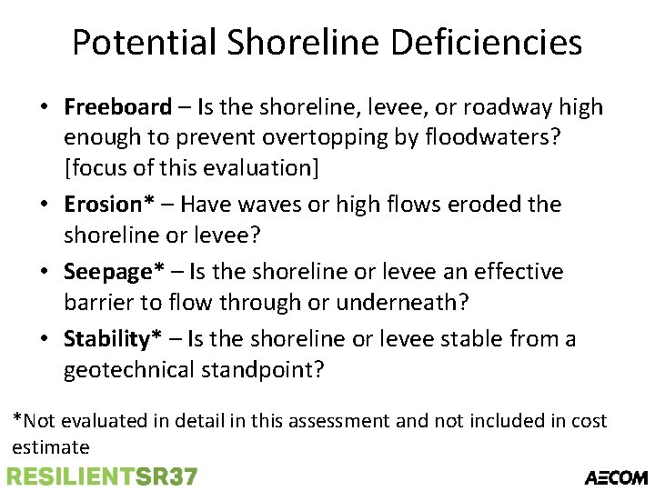
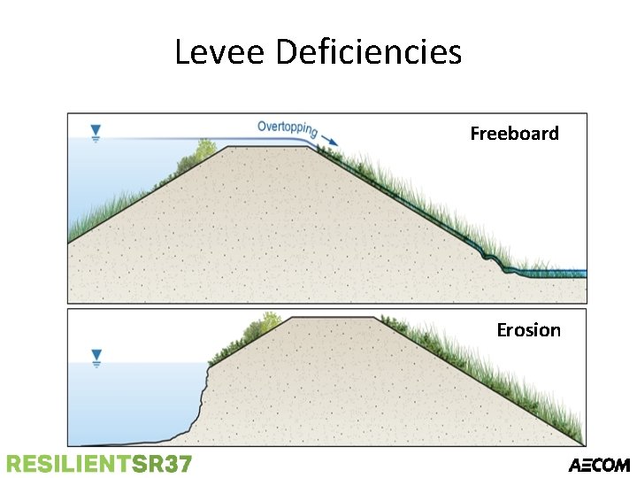
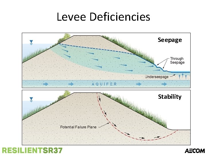
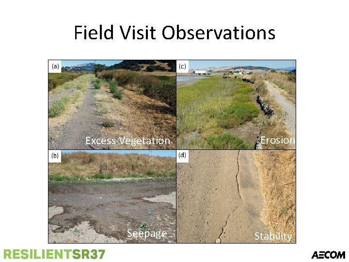
Potential Shoreline Deficiencies • Freeboard – Is the shoreline, levee, or roadway high enough to prevent overtopping by floodwaters? [focus of this evaluation] • Erosion* – Have waves or high flows eroded the shoreline or levee? • Seepage* – Is the shoreline or levee an effective barrier to flow through or underneath? • Stability* – Is the shoreline or levee stable from a geotechnical standpoint? *Not evaluated in detail in this assessment and not included in cost estimate
Levee Deficiencies Freeboard Erosion
Levee Deficiencies Seepage Stability
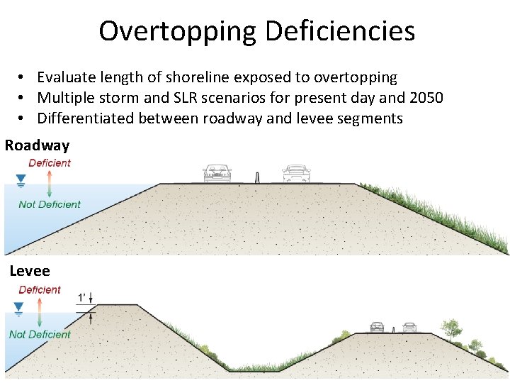
Overtopping Deficiencies • Evaluate length of shoreline exposed to overtopping • Multiple storm and SLR scenarios for present day and 2050 • Differentiated between roadway and levee segments Roadway Levee
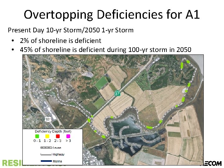
Overtopping Deficiencies for A 1 Present Day 10 -yr Storm/2050 1 -yr Storm • 2% of shoreline is deficient • 45% of shoreline is deficient during 100 -yr storm in 2050
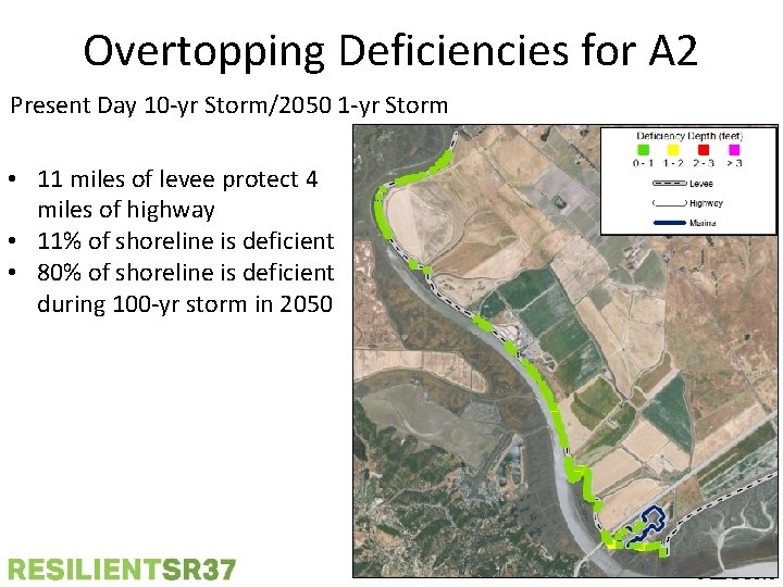
Overtopping Deficiencies for A 2 Present Day 10 -yr Storm/2050 1 -yr Storm • 11 miles of levee protect 4 miles of highway • 11% of shoreline is deficient • 80% of shoreline is deficient during 100 -yr storm in 2050
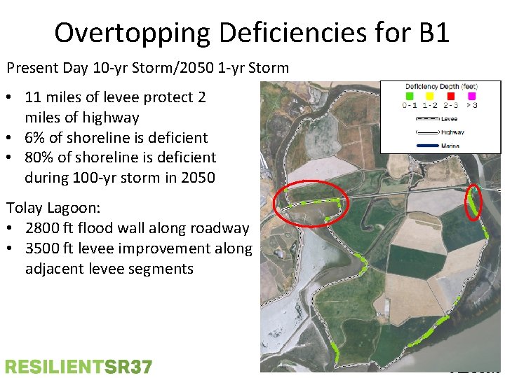
Overtopping Deficiencies for B 1 Present Day 10 -yr Storm/2050 1 -yr Storm • 11 miles of levee protect 2 miles of highway • 6% of shoreline is deficient • 80% of shoreline is deficient during 100 -yr storm in 2050 Tolay Lagoon: • 2800 ft flood wall along roadway • 3500 ft levee improvement along adjacent levee segments
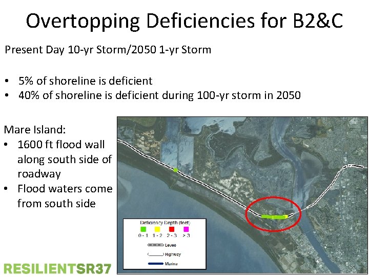
Overtopping Deficiencies for B 2&C Present Day 10 -yr Storm/2050 1 -yr Storm • 5% of shoreline is deficient • 40% of shoreline is deficient during 100 -yr storm in 2050 Mare Island: • 1600 ft flood wall along south side of roadway • Flood waters come from south side
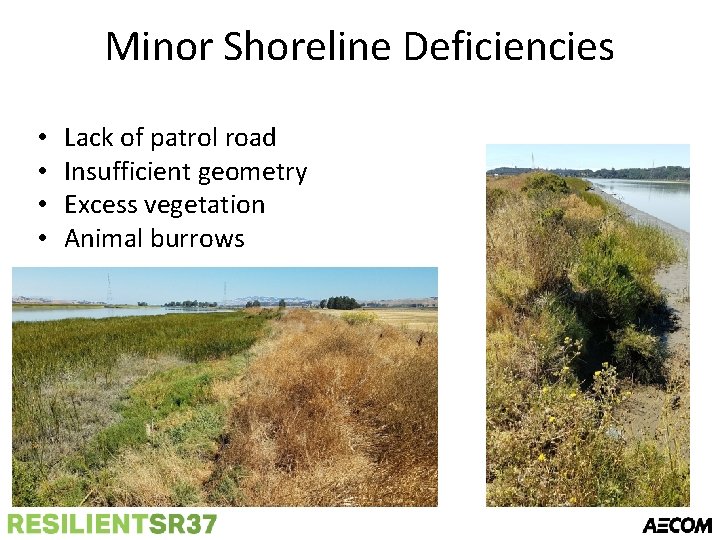
Minor Shoreline Deficiencies • • Lack of patrol road Insufficient geometry Excess vegetation Animal burrows
Field Visit Observations Excess Vegetation Erosion Seepage Stability
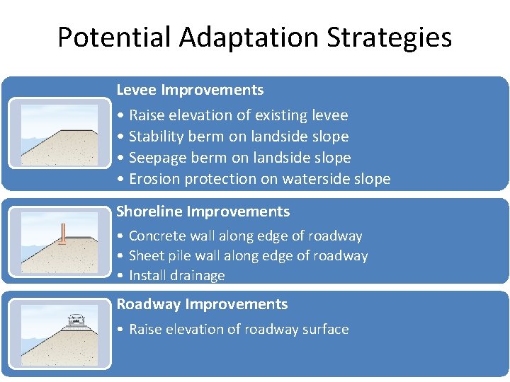
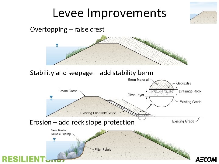
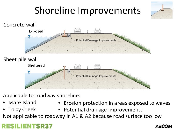
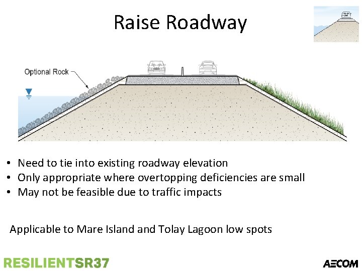
Potential Adaptation Strategies Levee Improvements • Raise elevation of existing levee • Stability berm on landside slope • Seepage berm on landside slope • Erosion protection on waterside slope Shoreline Improvements • Concrete wall along edge of roadway • Sheet pile wall along edge of roadway • Install drainage Roadway Improvements • Raise elevation of roadway surface
Levee Improvements Overtopping – raise crest Stability and seepage – add stability berm Erosion – add rock slope protection
Shoreline Improvements Concrete wall Exposed Sheet pile wall Sheltered Applicable to roadway shoreline: • Mare Island • Erosion protection in areas exposed to waves • Tolay Creek • Potential drainage improvements Not applicable to roadway in A 1 & A 2 because road surface too low
Raise Roadway • Need to tie into existing roadway elevation • Only appropriate where overtopping deficiencies are small • May not be feasible due to traffic impacts Applicable to Mare Island Tolay Lagoon low spots
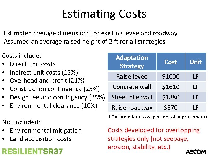
Estimating Costs Estimated average dimensions for existing levee and roadway Assumed an average raised height of 2 ft for all strategies Costs include: Adaptation • Direct unit costs Strategy • Indirect unit costs (15%) Raise levee • Overhead and profit (21%) Concrete wall • Construction contingency (25%) • Design fee and contingency (25%) Sheet pile wall • Environmental clearance (10%) Raise roadway Not included: • Environmental mitigation • Land acquisition costs Cost Unit $1000 $1610 $1880 $970 LF LF LF = linear feet (cost per foot of improvement) Costs developed for overtopping strategies only (not seepage, erosion, stability, etc. )
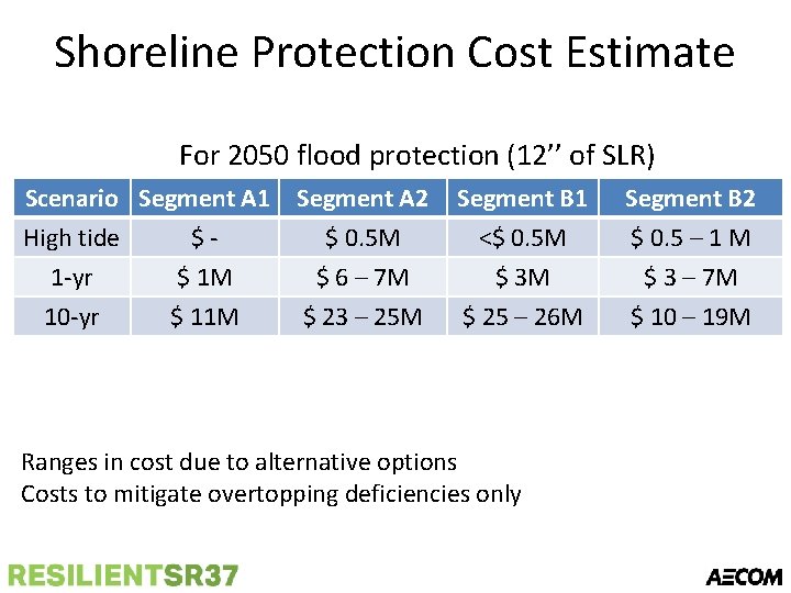
Shoreline Protection Cost Estimate For 2050 flood protection (12’’ of SLR) Scenario Segment A 1 High tide $1 -yr $ 1 M 10 -yr $ 11 M Segment A 2 $ 0. 5 M $ 6 – 7 M $ 23 – 25 M Segment B 1 <$ 0. 5 M $ 3 M $ 25 – 26 M Ranges in cost due to alternative options Costs to mitigate overtopping deficiencies only Segment B 2 $ 0. 5 – 1 M $ 3 – 7 M $ 10 – 19 M
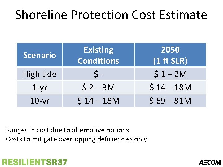
Shoreline Protection Cost Estimate Scenario High tide 1 -yr 10 -yr Existing Conditions $$ 2 – 3 M $ 14 – 18 M Ranges in cost due to alternative options Costs to mitigate overtopping deficiencies only 2050 (1 ft SLR) $ 1 – 2 M $ 14 – 18 M $ 69 – 81 M
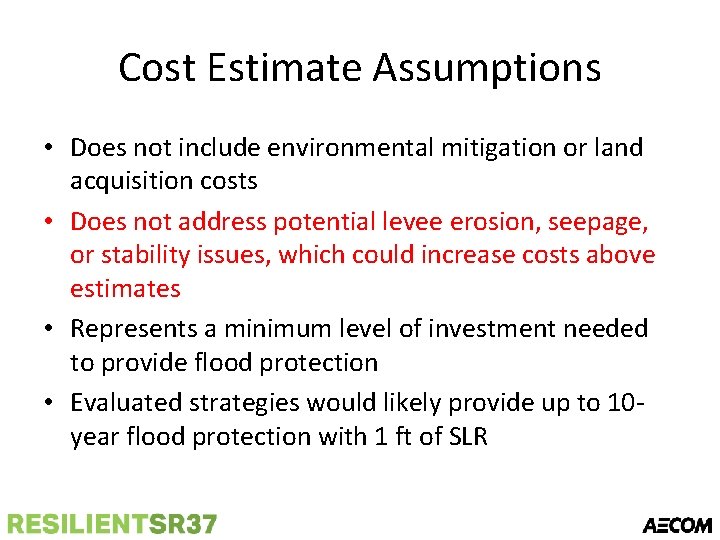
Cost Estimate Assumptions • Does not include environmental mitigation or land acquisition costs • Does not address potential levee erosion, seepage, or stability issues, which could increase costs above estimates • Represents a minimum level of investment needed to provide flood protection • Evaluated strategies would likely provide up to 10 year flood protection with 1 ft of SLR
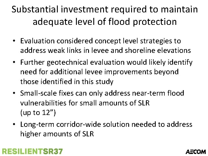
Substantial investment required to maintain adequate level of flood protection • Evaluation considered concept level strategies to address weak links in levee and shoreline elevations • Further geotechnical evaluation would likely identify need for additional levee improvements beyond those identified in this study • Small-scale fixes can only address near-term flood vulnerabilities for small amounts of SLR (up to 12”) • Long-term corridor-wide solution needed to address higher amounts of SLR