Lets Get Started To get you excited send


. Human Where and why humans are located as they are 2).")


. Coal factories in W. Virginia • Street names")


- Slides: 39
Let’s Get Started • To get you excited • send it in email • My advice edit that document (convert it to a Google doc…or have it up everyday we are not testing and take notes corresponding to it)
Geography • What is it? ? • Not as easy as you think
Geography Definition: Contemporary Definition: • Description of the Earth’s surface and the people and processes that shape its landscapes. • Complex challenge • Ever-changing • Social science • Way of thinking • Not just memorizing facts/places • Touches every aspect of human existence • Scientific study of the location of people and activities across Earth and the reasons for their distributions
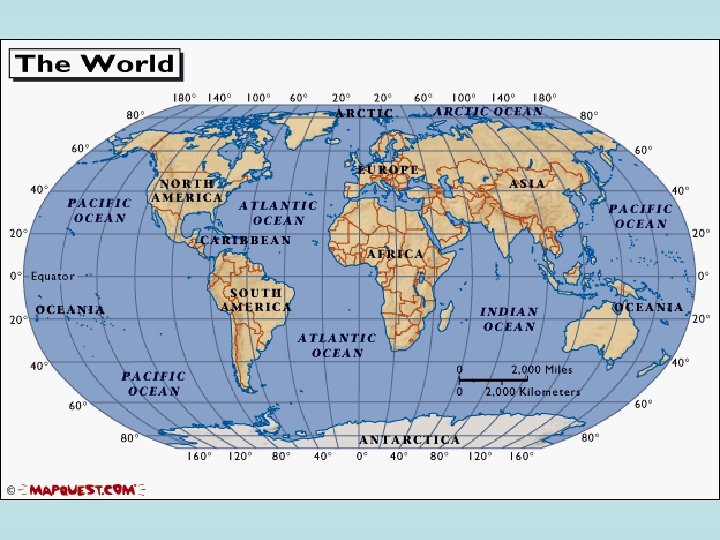
2 Branches 1). Human Where and why humans are located as they are 2). Physical Where and why natural forces occur as they do • Key Issues: • • • Thinking about space Thinking about place Thinking about region Thinking about scale Thinking about connections Later-5 Themes of Geo
History of the Field Geography • • Coined by the Greeks Erastosthenes Geo=earth Graphy=to write 2 simple questions 1). Where 2). Why Greeks • • Wrote about the Earth Homer’s Illiad and Odyssey Sailed around the Mediterranean Sea Established the 3 early continents: Europe, Asia, Africa (Libya) Aristotle, Socrates, Plato furthered the belief that the Earth was round Erastosthenes determined the circumference of the Earth with 99. 5% accuracy Anaximander made the first scale map of the world Accurate on large-scale of Mediterranean Sea, but not the rest of the world
Chimamanda Adichie: The danger of a single story • Send email of link • Watch, want you to be able to discuss tomorrow
Chapter 1: Thinking Geographically HW: Read Chapt. 1 Key Issues 1. 2. 3. 4. 5. Thinking about space Thinking about place Thinking about region Thinking about scale Thinking about connections
Key Issue 1 - Thinking About Space • Read the Intro • Geographers observe regularities across earth and depict them on maps • Thinking about Space – Spatial thinking is the most fundamental asset of a geographer ( Space to a Geographer is like time to a historian) – The process of understanding why people and activities are distributed across the space
What would you do – Geographers ask where and why not why and when – The key difference between historians and geographers is first hand experience
Key terms used to start • Distribution – Look around the room; Is the room set up regularly or in chaotic fashion? Why do you think it was set up this way? – Communities, cultures and cities are set up the same way, why? – The arrangement of a feature in space is known as distribution • There are three main properties of distribution; density, concentration and pattern
Terms • Density – The frequency in which something occurs in space is called density; look at the desk, how dense are they? – Arithmetic density is the density in which the total number of objects in one area; this is used in population • Ex. 59 million people divided into the square miles 94, 251 = 626 persons per square mile
Applied to our field – Large population does not mean large density, Why not? China has 1. 2 billion people but is not the highest density, why? – Density is also unrelated to poverty, Switzerland vs. Mali – Physiological Density- number of people in an area suitable for farmland, could mean difficulty in growing food – Agricultural Density- number of farmers in an area, could mean inefficient agriculture – High Housing Could mean what?
Terms • Concentration – The extent of a features spread over space is concentration – Describes changes in distribution • NY concentration decreases as what happens – Concentration and distribution are different • Think of the same amount of houses in a neighborhood with different yard sizes – Baseball teams and expansion teams • How do they change over time compared to concentration and density?
Terms • Pattern – Geometric arrangements of objects in space – Grids laid down by the Land ordnance of 1785 • How about Greenville • 30 Baseball teams are located in the Metropolitan areas of the north – Page 6 of your book
Maps, yes, we need to talk • Maps – Two dimensional or flat scale model of the earths surface • Most important tool of a Geographer – Cartography the art of map making- one of the oldest professions- 2300 BC- Babylonians – There are two functions • 1 - reference material • 2 - Geographic information • Start on pg 6 and carry over to 8, Write down the people and the differences they brought to map making skills
Moving on up • Contemporary mapping – Remote Sensing- the acquisition of data from long distance • Satellites can analyze small areas called pixels or picture element – Geographic Information System (GIS) • Analyze many components of a map at once layered on each other, Population and geography etc. . – GPS • We know this one- Time travel can be proved through this phenomena
What is wrong with maps • Projection – The process of transferring data from a spherical reference to a flat reference – Four types of distortion can accrue 1. 2. 3. 4. Shape Distance Size Direction – Equal area projections are mostly used • Size of populated areas are more important
Key Issue 2 - Thinking about Place • Feeling for the feature that contribute to the distinctiveness of a particular place • Location – The position something occupies on earths surface • Names – Toponym- is the name given to a place on earth • • Names of places related to figures or objects, Charleston Religious Sayings, Eureka Physical environment – Offensive racial names and slurs are going to be changed – Changes due to political upheaval; Eastern Europe or the Middle East
Where we see it • Names and Places – British- N America and Australia – Portuguese- Brazil – Spanish- Latin America – Dutch- S. Africa
Further • Town names – Ex). Coal factories in W. Virginia • Street names
Terms Again • Site – The physical character of a place – Rivers, Hilltops, Islands have been good places to start cities, why? Can they make more? NY • Situation – The location of a place relative to another place • Helps us find an unfamiliar place by locating a familiar one • The situation also allows us to see the importance of a location compared to accessibility to another place
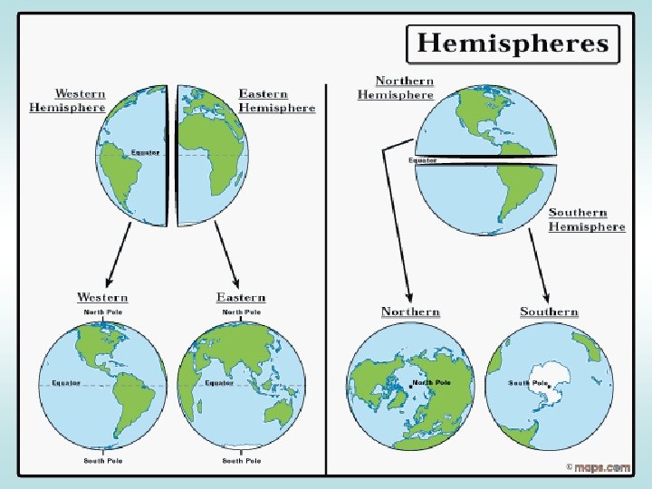
Latitude and Longitude • The earth is divided into lots of lines called latitude and longitude.
Lines • Longitude lines run north and south. • Latitude lines run east and west. • The lines measure distances in degrees. Latitude Longitude
However • Longitude measures= • Latitude measures=
Where is 0 degree? • The equator is 0 degree latitude. • It is an imaginary belt that runs halfway point between the North Pole and the South Pole. Equator
M Where is 0 P degree? E R • R I 0 I degrees The prime meridian is D M longitude. This imaginary line runs I through the United Kingdom, France, E A N Antarctica. Spain, western Africa, and
Hemispheres • By using the equator and prime meridian, we can divide the world into four hemispheres, north, south, east, and west.
Important • MCD • LDC • Later, Projections. . Polar projection, Development
Physical Geography • Mathematical Situation – Location can be found precisely through the meridians and parallels • Meridian- an arc between north and south poles – Each Meridian is located through the use of longitude – Greenwich, England- Prime Meridian 0 Longitude » All others have numbers between 0 and 180 degrees • Parallel- circle around the globe; right angles to the meridian – Each parallel can be found through latitude – Equator is 0, North and South poles are 90 • Each degree is divided into 60 min and then into 60 sec – Precise location of all features on a map
Key Lines • Time from Longitude – Time Zones- 24 zones divided into 15 degrees of Longitude, map on pg 15 • Greenwich Mean Time- or Universal Time is the master reference why? – International Date Line- past 180 degrees either way adjust the time by 24 hours • Determining Longitude – Longitude is man made creation; Longitude act of 1784 established it permanently
Time Zones • The Earth is divided into 24 time zones, corresponding to 24 hours in a day. • As the earth rotates, the sun shines in different areas, moving from east to west during the course of a day. • Places that have the same longitude will be in the same time zone.
Key Issue 3 - Thinking about Region • Region – An area of earth described by one or more specific characteristic, North East vs. South East – A region gains its uniqueness through human and environmental differences, BBQ vs. Bagels • Formal Region – Also called a formal region- described by homogeneous characteristics; language, economy, crop, government • Problem lies in the minorities of that region • Functional Region – Also known as a nodal region- organized around a node or focal point • Shops, services, newspapers, radio, TV
• Vernacular region – Perceptual region- cultural identity , map pg 18, north vs. south, east vs. west • Seen for the south as a place of pride and for others a place to avoid • Regional Integration/ Culture – Culture- customs, traits, beliefs, material belongings, traditions of a particular group • 2 traits of culture – What people care about • Language, Religion, Ethnicity define this – What people take care of • Wealth, food, clothing, shelter – MDC- More developed Economically, USA, Japan, made goods – LDC- Less developed Economically, Africa, Middle East, Agriculture
• Cultural Ecology- Human environment relationship – Environmental determinism- people actions are caused by their environment • Alexander Humbelt, Carl Ritter, Fredrick Ratzel, Ellen Churchhill Semple, Ellsworth Huntington – Possibilism- peoples actions are limited to their environment, Domestication of animals • Regionalism • Resources, food production, buildings etc. . – Wealth and technology influence both of these, how?
Need to know • Climate is often classified by German Vladimir Koppen– Five specific main climates • • • Tropical Climates dry Climates Warm mid-latitude climates Cold mid-latitude climates Polar climates
Key issue- 4 Thinking about Scale • Scale- the scope of a particular idea or function, “ Think globally act locally” • Map Scale – Relation of something's size and its actual size on the earth – Most are scaled down, obviously • Spatial Association – Scaling from a very small portion to a very large portion depending on your need, pg 24 • Globalization – The force or process that involves the entire world • Globalization of Economy – Transitional Corporations- Lead the charge of globalization, GE, BP • All economies are global and effect each other in the manner
Key Issue 5 - Thinking about Connections • Space Time connection- the time it takes for something to reach another place, News • Spatial Interaction – In the past people had to move or travel to spread information, what do we rely on now? • Networks – Chains of communication that connect places • ABC, CBS, Airline Hubs • Distance decay- The further one place is from another the less interaction they have to its eventual disappearance