Lecture 8 Cloud Types Fog What is a


 Updraft (~1 -10 m/s) Cloud Base, Lifted")
 CCN – Serve as the")
 particles –")


 VERTICAL 1) HIGH CLOUDS 2) MIDDLE CLOUDS 3) LOW CLOUDS")


 High Cirrus (Ci)")


- Slides: 30
Lecture 8 Cloud Types & Fog
What is a cloud? ? ? • A cloud can be defined as any visible aggregate of tiny droplets of water or tiny ice crystals, or a mixture of both –They help meteorologists figure out what’s going on in the atmosphere
Cloud Droplet Formation Cloud Drop (10 um) Updraft (~1 -10 m/s) Cloud Base, Lifted Condensation Level (LCL)
Recipe for a Cloud 1. Cloud Condensation Nuclei (CCN) CCN – Serve as the surface for water vapor to condense upon 2. Rising Air – By one of the methods described before. – Causes adiabatic cooling – Condensation occurs at the LCL 3. Water Vapor
Why do you need CCN? • The best particles are hygroscopic (water-seeking/liking) particles – Sea salt is a good example. • Hydrophobic Particles (water repelling) can still serve as nuclei when RH is > or = 100%. • Without CCN the RH would have to be much greater than 100% for a cloud drop to form.
Why are cloud drops so TINY? ! • at first the drops grow really FAST • But…. Lots of other aerosol WANT water too… • So the water vapor is split up over a lot of little drops instead of a few big ones.
Why are cloud drops so TINY? ! Available Water Vapor 5 CCN Available Water Vapor 20 CCN
Why are cloud drops so TINY? ! Available Water Vapor 20 CCN 5 CCN Big Cloud Drops Small Cloud Drops
Cloud Classification 4) VERTICAL 1) HIGH CLOUDS 2) MIDDLE CLOUDS 3) LOW CLOUDS
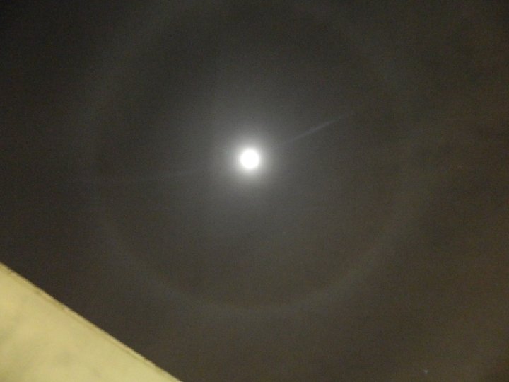
High Clouds • Cirrus – Fibrous, “mare’s tails” • Cirrostratus – White, produces halo – Approach of warm front • Cirrocumulus – White, small cells or ripple – looks like “Fish Scales” • Above 6000 m (20, 000 ft) • ICE ONLY • No Significant Precipitation
Middle Clouds • Altocumulus – Large patches of rounded masses or rolls – Usually water droplets • Altostratus – Formless layer of grey cloud cover – Sun is only visible as a bright spot. – NO Halos JPL – Pasadena, CA • Between 2000 -6000 m (6, 500 -20, 000 ft) • Mostly Water • Infrequently Precipitates Snow or Drizzle Beach in Long Island, NY
Low Clouds • Stratus – Uniform layer covering most of sky – Sometimes precipitation • Stratocumulus – Scalloped bottom, covering most of sky – Long parallel rolled or blobs • Nimbostratus – Chief precipitation producers (light but for a long time) – Associated with Stable conditions • Below 2, 000 m (6, 500 ft) • LIQUID ONLY
Clouds of Vertical Development • Cumulus – Individual masses that develop into vertical domes or towers – Tops often resemble cauliflower – Form on clear days • Cumulonimbus – When Cumulus grow out of control – Dark, dense, billowing clouds – VERY TALL 12 -20 km (7 -12 miles) • Bases are low (below 2, 000 m) Tops up to 20 km!! • Water at the base, can have ice if they grow tall enough (into cold air) • Related to unstable air
Photo Credit: Travis Marcombe
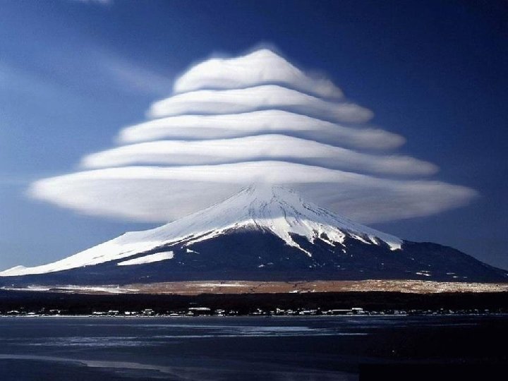
Cloud Varieties – Additional Terms • Mammatus – Looks like udders – Happen after/before severe weather or Thunderstorms • Lenticular – Looks like lentils or lenses – Most often seen near mountains
Cloud Type Summary Table Cloud Family & Height Cloud Type (abbreviation) High Cirrus (Ci) Info Thin delicate filaments, ICE crystals, wispy Above 6000 m Cirrostratus (Cs) Cirrocumulus (Cc) Middle Altocumulus (Ac) Thin white sheet, ICE crystals, produce halos around sun and moon Thin white, ICE crystals, and look like fish scales White to grey, blob like… though widespread Between 2000 -6000 m Altostratus (As) Low Stratus (St) Thin veil of clouds, may see sun as a disc but no halos Low uniform layer, like fog, may produce drizzle Below 2000 m Vertically Developed Stratocumulus (Sc) Soft, grey clouds, blobs and batches or rolls. Nimbostratus (Ns) Dark grey formless clouds, RAIN producers Cumulus (Cu) Cumulonimbus (Cb) Have flat bottoms, fair weather, billowy, cauliflower tops Towering clouds, sometimes form anvil heads, Heavy rainfall, hail, lightning, thunder and tornadoes
NAME THAT CLOUD Lenticular Cirrus Stratocumulus Cumulus
Types of Fog • FOG = a cloud with its base at or very near the ground. • Fogs formed by Cooling – Radiation Fog – Advection Fog – Upslope Fog • Fogs formed by Evaporation – Steam Fog – Frontal Fog
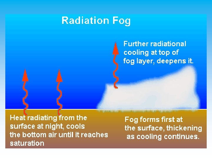
Fogs Formed by Cooling • Radiation Fog – The ground cools the air close to the surface – A night time phenomenon – Clear Skies – Fairly high RH – Cold air sinks in valleys – Dissipate after sunrise
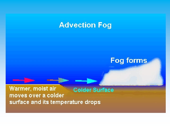
Fogs Formed by Cooling • Advection Fog – Warm moist air is blowing over a cold surface – Advection = horizontal movement – Turbulence (wind) is needed to make it thick
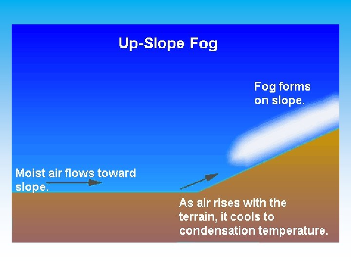
Fogs Formed by Cooling • Upslope Fog – Humid air moves up a gradual sloping plain or mountain • As it moves up it cools… if to dew point you get fog – Ex: Great Plains • Moist air from Gulf moves up towards the Rockies
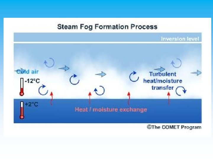
Fogs Formed by Evaporation • Steam Fog – Cool air moves over warm water – Rising air cools and condenses – Moister added into the layer!!!!
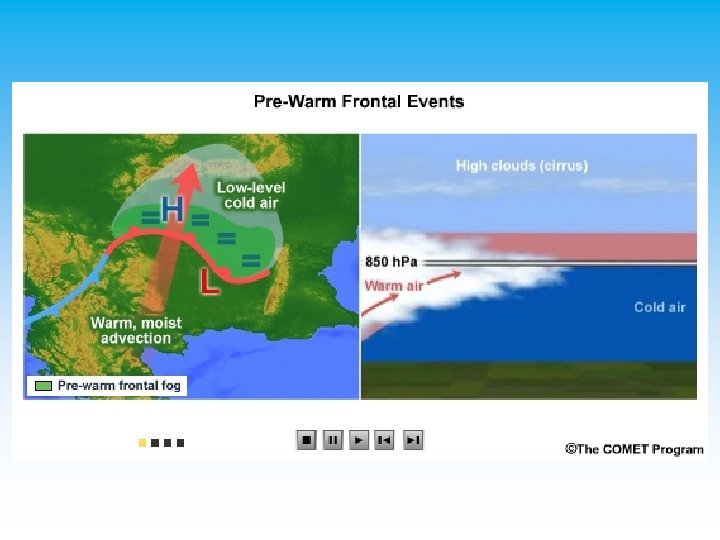
Fogs Formed by Evaporation • Frontal Fog – After warm air is pushed upward – If cold air is near dew -point rain can evaporate and then produce fog – Results from the addition of water vapor into a cool layer of air