Lecture 7 S American Climate Physical Settings Circulation


 is a cold ocean current that flows northward")

 was a Prussian naturalist")


 for part of the year.")

, Peru.")


 l A")
 low-level cross equatorial flow 2) northwesterlies")


- Slides: 54
Lecture 7 S. American Climate • Physical Settings • Circulation controls • Climate Change — Impacts of Amazonian Deforestation
Topography Like Africa, primarily a tropical continent e cz on itu di na l cy clo ni m. T -la t Continent extends farther poleward than any other S. H. continents — 56 S, coming within 7 degree of Antarctic peninsula f. T M id Distinguish characteristic is the unbroken, high Andes Mt. chain that run the entire length near its west coast — allow the greatest meridional penetration of air masses anywhere in the S. H. m. T
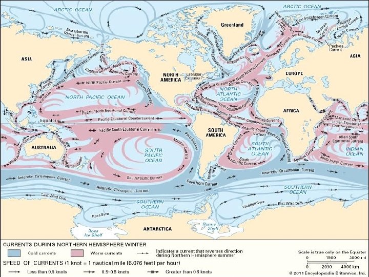
The Guiana current is fed by the North Brazil Current a major source of water for the Caribbean Sea. Water transported by the Guiana current also mixes with tropical waters from the N. Equatorial Current and eventually feeds the circulation of the N. Atlantic subtropical Gyre, via the Caribbean, Yucatan, Loop, and Florida currents.
The N. Brazil current transports a significant amount of water, including freshwater from the Amazon, northwestward along the coast of northern Brazil, French Guiana, and Suriname. It is fed by the S. Equatorial Current and part of it becomes the Guiana Current.
No r th e rn bo un da ry of SA CZ The Brazil current is the western boundary current of the South Atlantic subtropical gyre. Near 22 S, the Brazil current splits; one component flows eastward and the other component hugs the coast and flows toward the southwest and interacts with the colder Malvinas Current.
So ut he rn bo u nd a ry of SA CZ The Malvinas current is the northward flow component of the S. Atlantic subpolar gyre. It transports cold water along the coast of S. America and this water mixes with warmer waters of the Brazil current in an region known as the Brazil-Malvinas confluence.
The Peru Current (or Humboldt Current) is a cold ocean current that flows northward off the west coast of S. A. It becomes a major part of the westward South Equatorial Current. This current originates in the Southern Ocean near the Antarctic, and is thus about 7 -8 C° cooler than the ocean at similar latitudes. The cold water cools down the air, creating the coastal deserts of Chile: the Atacama and Peru. However, the Humbolt Current brings nutrient-rich seawater into the region, forming the basis for a rich fishing industry on Peru and Chile.
MAIN FISHERY RESOURCES SARDINE ANCHOVY PELAGIC PACIFIC MACKEREL JACK MACKEREL LIGHTFISH DEMERSAL HAKE INVERTEBRATES JUMBO FLYING SQUID PERUVIAN SCALLOP
Baron Alexander von Humboldt (September 14, 1769 -May 6, 1859) was a Prussian naturalist and explorer who explored much of Central and South America. Humboldt and his friend, the French medical doctor/botanist Aime. Jacques-Alexandre Goujoud Bonpland (1773 -1858), explored the coast of Venezuela, the Amazon and Orinoco Rivers, and much of Peru, Ecuador, Colombia and Mexico (1799 -1805). On their many expeditions, Humboldt and Bonpland collected plant, animal, and mineral specimens, studied electricity (including discovering the first animal that produced electricity, Electrophorus electricus, the electric eel), did extensive mapping of northern South America, climbed mountains (and set altitude records), observed astronomical phenomena, and performed many scientific observations. The scientist Carlos Montufar (who later became a revolutionary in Ecuador) acconpanied them on part of the trip.
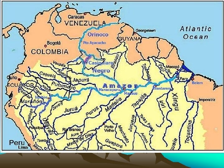
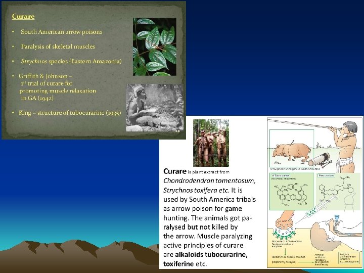
Humboldt discovered what is now called the Humboldt Current off the west coast of South America, while he was investigating why the interior of Peru was so dry. It is a cold ocean current that runs along much of the western coast of South America, and is also known as the Peru Current. Humboldt was the first European to witness native South Americans preparing curare arrow poison from a vine. He was also the first person to recognize the need to preserve the cinchona plant (its barks contain quinine, which is used to cure malaria, and it was terribly over-harvested at the time). Humboldt was the first person to make accurate drawings of Inca ruins in South America (he visited the ruins at Canar, Peru). Humboldt and Bonpland first discovered and mapped the Casiquiare Canal, the only natural canal in the world that connects two major rivers (the Orinoco River and the Negro River, a tributary of the Amazon). Humboldt was also the first person to discover the importance of guano (the dried droppings from fish-eating birds); it is an excellent fertilizer.
After their South American expeditions, Humboldt and Bonpland visited the USA and were guests of President Thomas Jefferson in Washington, D. C. , for three months in 1804 (their visit happened just after Jefferson had sent Lewis and Clark to explore the western US). At the age of 60, Humboldt traveled to the Ural mountains in Siberia and to Central Asia to study the weather. He wrote extensively of his travels and discoveries. One of his books, A Personal Narrative inspired a young Charles Darwin. His last work was his multi-volume book, Kosmos, which tried to unify all of science. Humboldt died at age 90 (leaving Kosmos unfinished), and is buried in Tegel, Germany. Many landmarks in the Americas, including a current, a river, a mountain range, a reservoir, a salt marsh, parks, many counties and towns are named for Humboldt. On the moon, the Mare Humboldtianum (Humboldt's Sea) was named for Humboldt.
The cold currents around the Galapagos cause garua (mist) for part of the year. Early sailors thought the islands were enchanted as a result of their frequent disappearance.
View of clouds over the ocean off Peru
Sunset over the southeastern Pacific from Paracas bay (14 S, 76 W), Peru.
“Those who have seen the green flash will never err in the matters of love. ”
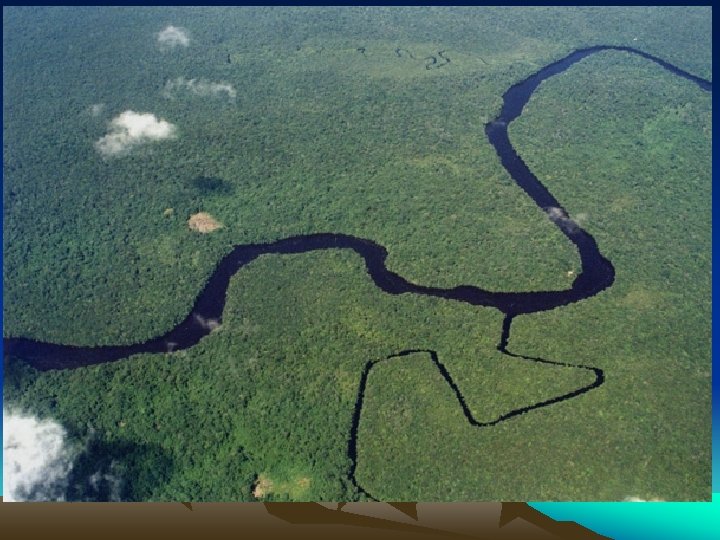
Amazon rainforest, near Iquitos Peru rainforest in eastern Peru
Altiplano plateau, Peru Atacama desert, Chilean coast
Trewartha Climatic Classification System
• Physical Settings • Circulation controls • Climate Change — Impacts of Amazonian Deforestation
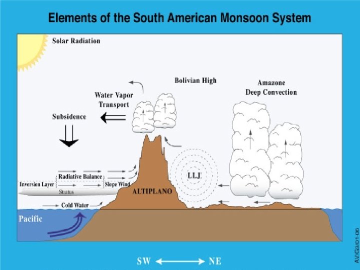
Chaco Low
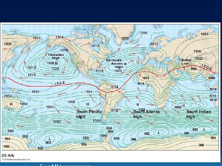
Positionally Stable Pacific Subtropical High The shape of the west coast of S. A. forms a near-perfect “basin” into which the S. Pacific STH can fit snugly and maintain contact with the continent almost to the equator January July No other STH is so positionally stable and so perfectly anchored along a coast; produces maximum subsidence in the coastal area
Less “Unstable” Influences of Atlantic Subtropical High To the east, air in the Cf region (Brazil) is not nearly as unstable as that in the Cf region of N. America (i. e. SE of U. S. ) due to continent’s shape which bulges eastward into the influence of the more stable part of the South Atlantic STH. January July
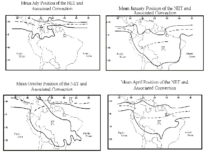
Unique ITCZ Behavior Intrusion of Cold Front
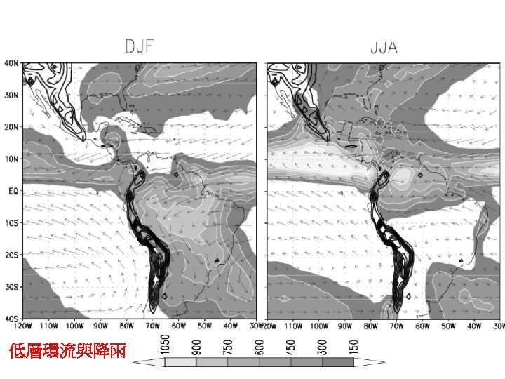
Moisture sources of La Plata basin of southeastern S. A.
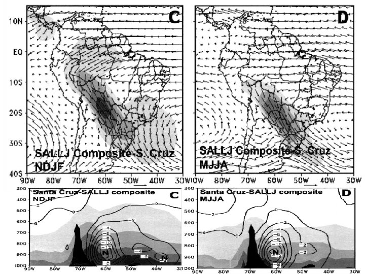
Mean calendar date of onset of South American monsoon
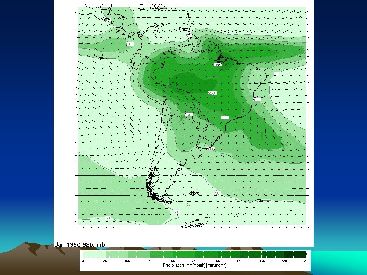
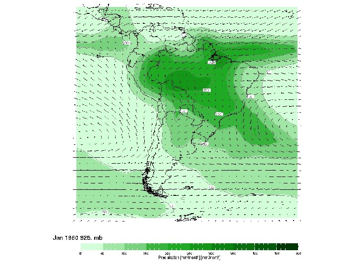
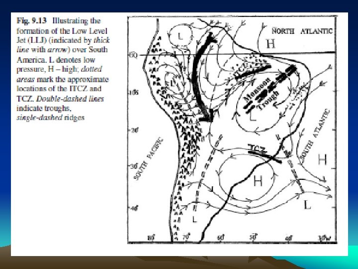
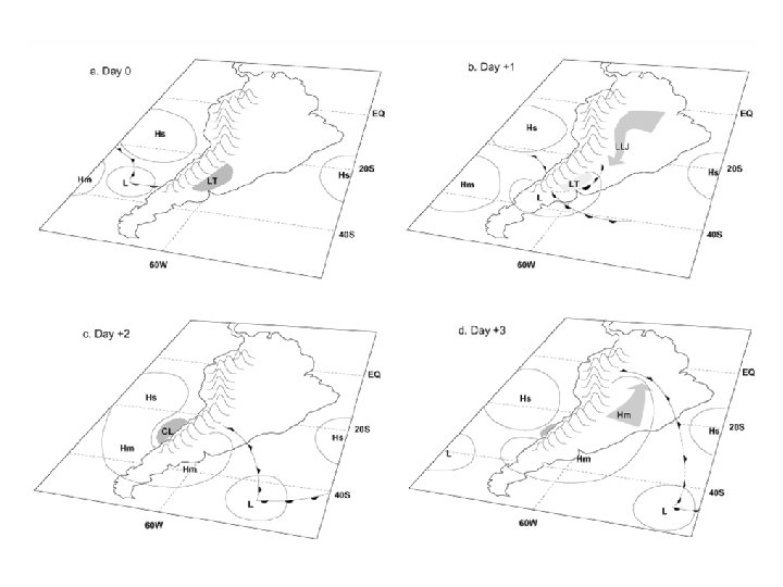
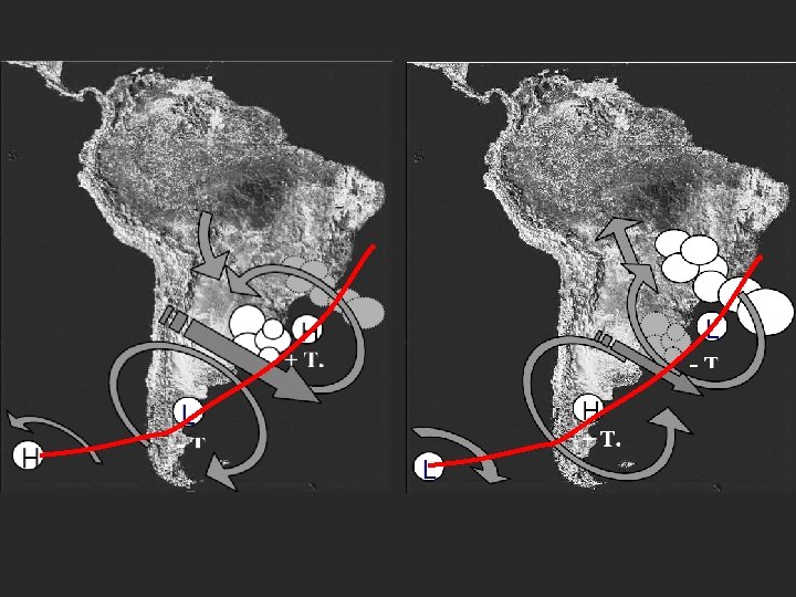
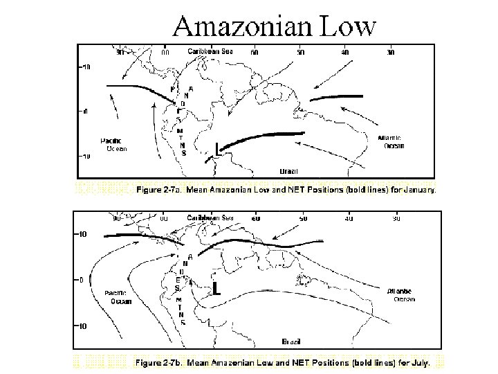
Climatic Control Features in South America The Amazonian Low (Gran Chaco Low) l A semi-permanent feature of the Amazon Basin -Focus for moisture xxxxconvergence…enhancing xxxxconvection -Favorably interacts with the xxx. NET l Warm core cyclone -Latent heat released during xxxxcondensation -Orographically induced by xxxxthe Andes
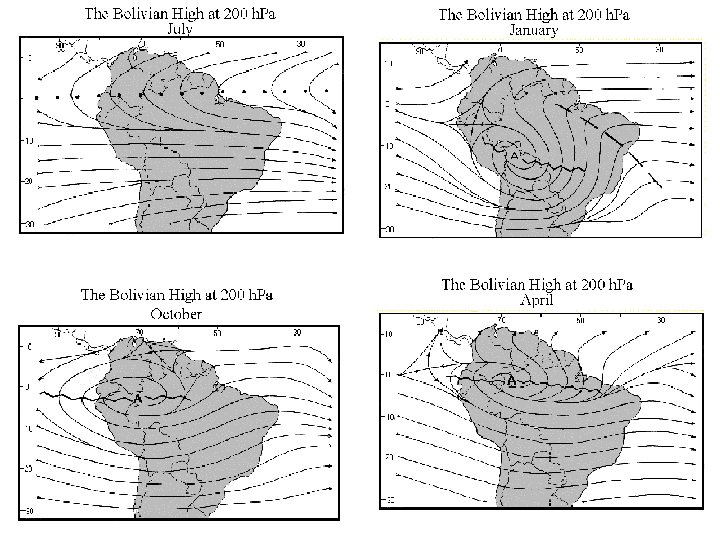
Monsoon components in SA and Asia tradewinds 1) low-level cross equatorial flow 2) northwesterlies vs. southwesterlies 3) Gran Chaco low vs. EASM trough 4) Subtropical high tradewinds 5) SACZ vs. Mei-Yu frontal zone 6) mid-latitude westerlies 7) Bolivian high vs. Tibetan high 8) upper-level return flow
• Physical Settings • Circulation controls • Climate Change — Impacts of Amazonian Deforestation
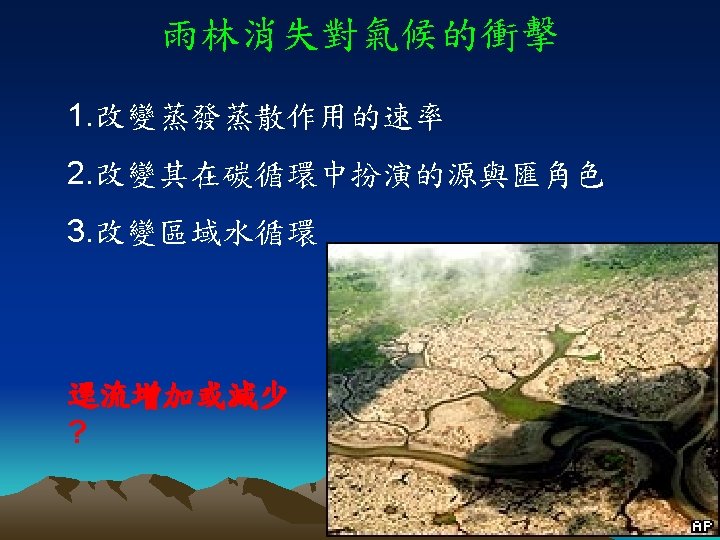
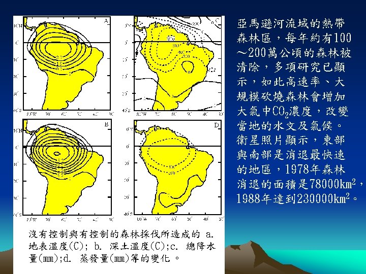
Title Deforestation: Rondonia, Brazil Body text • 1975 -Healthy natural vegetation • 1986 -“Fishbone” pattern on the landscape indicate agriculture fields Satellite images reveal in startling detail the signs of human impact on the landscape. Evidence that people have become a powerful force capable of reshaping the Earth’s environment is everywhere. • 2000 -Agriculture continues to replace forest cover.
Differences between simulated parameters: Short grass minus Forest Decrease in precipitation Increase in precipitation Local temperature increase reaching until 5°C
Differences between simulated parameters: Short grass minus Forest The increase in maximum temperature is larger than the increase in minimum temperature
Differences between simulated parameters: Short grass minus Forest Ground Temperature Foliage Temperature Ground and foliage temperature is higher in the short grass in the Amazon region, and is lower in other areas
Differences between simulated parameters: Short grass minus Forest Dryer Moister
Differences between simulated parameters: Short grass minus Forest Over the Amazon the lower level winds ( σ=1) became more intense in the short grass