Latitude and Longitude The Absolute Location of Any

Latitude and Longitude The Absolute Location of Any Place on Earth

How can I remember which lines are which?

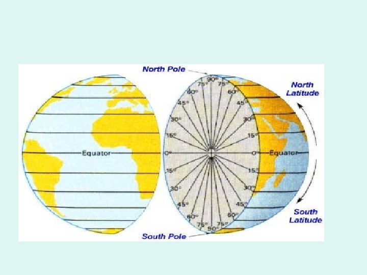
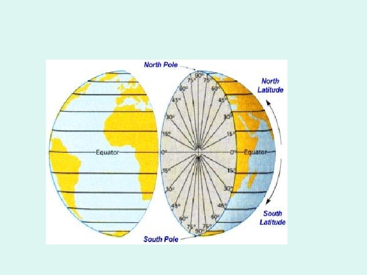
• Latitude lines are imaginary lines on the earth's surface. They run east and west around the globe and tell your distance north or south of the Equator

Think of latitude like the rungs of a ladder (ladder sounds a lot like latitude). Latitude lines run east and west, but they tell how far up (north) you can go or how far down (south) you can go.

• Longitude lines are imaginary lines on the earth's surface that run from pole to pole around the globe and tell your distance east or west from the Prime Meridian

When you think of longitude, think of long, tall telephone poles (because longitude lines run from pole to pole). Longitude lines run north and south, but they tell how far east or west that you can go.

• In the field of mathematics, circles are measured in degrees. There are 360 degrees in a circle. Since the earth is basically circular, it was decided to measure latitude and longitude in degrees also. • The first latitude line was the Equator (equally distant between the north and south poles). It is the largest of all latitude lines. All other latitude lines are measured in degrees north or south of the Equator. There a maximum of 90 degrees of latitude to the north or the south of the Equator.

• The first longitude line was the Prime Meridian. Any meridian could have been chosen as the Prime Meridian because they are all exactly the same. The Prime Meridian was selected by international agreement at the International Meridian Conference called by President Chester Arthur in October of 1884. Representatives from 25 nations met in Washington, D. C. All other longitude lines are measured in degrees north or south of the Equator. There a maximum of 180 degrees on longitude to the east or the west of the Prime Meridian.
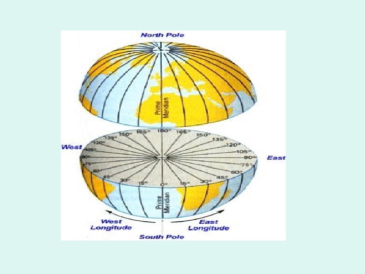

• It is approximately 70 miles between two latitude lines. For more accuracy in location, degrees can be divided into smaller parts. One degree can be divided into 60 minutes (') and one minute can be divided into 60 seconds (").

• How do I use latitude and longitude? • If someone asked you the location of the local town bank, you may say "It is on the corner of Main and Third streets. " Latitude and longitude are like imaginary streets on the earth. • It is customary to give the latitude of a place first, and the longitude second. For example, you would say "35 degrees north, 77 degrees west". This eliminates the need to say the words latitude and longitude. Make sure that you give a direction with the number. If you simply say "66 degrees latitude", there are two of them - one in the north and one in the south.

• • To find a latitude line such as 60 degrees north latitude, you must do three things: 1. Go to your starting line (the Equator). 2. Determine which direction you must go (north or south). 3. Determine the distance in degrees you must go (60). This will give the location of one of your streets.

• • To find a longitude line such as 40 degrees east longitude, you must do three things: 1. Go to your starting line (the Prime Meridian). 2. Determine which direction you must go (east or west). 3. Determine the distance in degrees you must go (40). This will give the location of one of your second street.

• • If you find the intersection of these two imaginary streets, you have found the exact (absolute) location of a particular place on the earth's surface (shown by the red "X" on the map to the right. Important: The Equator is neither North nor South of the starting line, so it is simply 0º latitude (no direction needed). The Prime Meridian would be 0º longitude (no direction needed). Notice this on the two diagrams.

Using Latitude and Longitude - Skill Builder

When would I ever use latitude and longitude? • • In real life, there are several instances where you would need to know how to find latitude and longitude. For example, when weather forecasters are tracking hurricanes, they note the absolute location on a periodic basis to see the path of the storm and try to predict the future path based partially on these findings.

• • • Another example would be in the military. Suppose you were at war and you wanted to blow up an ammunition factory, but not the hospital nearby. Using minutes and seconds of latitude and longitude, you can launch a missle from hundreds of miles away and strike only that particular bulding. If you wanted to license a CB base station, or even license 5 -mile range walkie talkies, you need to provide the latitude and longitude of your home to the Federal Communications Commission to get such a license. In an emergency situation, like a plane crash or a boat sinking, you can relay your coordinates of latitude and longitude to assist rescue teams when time may be very important. If you are in the middle of an ocean, there are no landmarks to use, so you had better know your latitude and longitude.

Quiz Time • • • 1. Latitude and longitude are measured in __________. 2. Lines of latitude can be thought of like telephone poles. T or F 3. The Prime Meridian Conference was called by President ____? • 4. Which lines run north and south along the earth's surface? Choose all that correct answers that apply. [A] latitude lines [B] longitude lines [C] Equator [D] Prime Meridian • 5. The starting line for measuring latitude is the: [A] Prime Meridian [B] Arctic Circle • [C] International Dateline [D] Equator

• 6. The highest number of degrees in latitude is 90. True False • 7.
- Slides: 21