Latitude and Longitude Learn to understand the latitude


- Slides: 50
Latitude and Longitude Learn to understand the latitude and longitude lines running across your maps and globes
Where On Earth Are We? The ancient Babylonians originally divided any circle or sphere into 360 degrees.
Where On Earth Are We? There are 180 degrees between any two sides of a circle or sphere.
Where On Earth Are We? The north and south poles are 180 degrees apart from one another, and both are 90 degrees from the equator.
Where On Earth Are We? The equator is the imaginary line that is centered between the North and South Pole.
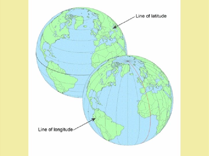
Latitude The horizontal lines that circle the globe are called Lines of Latitude.
Latitude Lines of Latitude are also known as parallels because they parallel, or run in the same direction as the Equator.
Tropic of Cancer • The Tropic of Cancer is the northern most latitude where the Sun can be directly overhead.
Tropic of Capricorn • The Tropic of Capricorn is the southern most latitude where the Sun can be directly overhead.
Longitude • The lines that run between the North and the South Poles are called Lines of Longitude, or meridians.
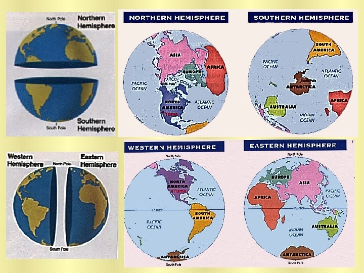
Hemispheres • Geographers divide the earth into hemispheres.
Hemispheres • Everything north of the equator is in the Northern Hemisphere, while everything south of the equator is in the Southern Hemisphere.
Hemispheres • The Western Hemisphere is west of the Prime Meridian, while the Eastern Hemisphere is east of the Prime Meridian.
Hemispheres • The hemispheres both end at the International Date Line.
What Hemisphere? 71° 43° The United States is in the Northern and Western Hemispheres. Concord is 71° west of the Prime Meridian and 43° north of the equator. This is commonly expressed as 43°N, 71°W
The Prime Meridian
Prime Meridian 0 degrees longitude • The line at zero degrees longitude is called the Prime Meridian.
Prime Meridian • Meridians are counted east and west from the prime meridian, which is numbered zero degrees longitude.
Prime Meridian • The Prime Meridian runs through the Royal Observatory in Greenwich, England.
International Date Line • The International Date Line is located 180 degrees from the prime meridian. • When it is noon along the prime meridian, it is midnight along the International Date Line. On the other side of the world from the Prime Meridian is the International Date Line.
Label the Latitude and Longitude 0º Longitude 45º E 90º N 90º S 180º W 0º Latitude 45º N 45º S 135º W 90º W 45º W 90º E 135º E 180º E
Answer Key: How did you do?
Latitude and Longitude Battleship
Getting Ready Step 1: Use your pen to darken in the Equator on your map.
Getting Ready Step 1: Use your pen to darken in the Equator on your map. Step 2: Darken in the Prime Meridian on your map.
NW SW NE SE
NW NE The Prime Meridian is an imaginary line of longitude that divides the Earth into the Western… SW …and Eastern Hemispheres. SE
NW NE Now the map is divided into four major quadrants, just like a graph. x-axis y-axis SW SE
NW NE This is the northeast quadrant. SW SE
NW NE All locations here are x latitude north by x longitude east. SW SE
NW NE The ship is on the 40 degree south latitude line. SW SE
NW NE This is the northwest quadrant. This is the southwest quadrant. SW All locations here are x latitude north by x longitude east. This is the southeast quadrant. SE
NW NE Notice the ship in the southeast quadrant. Its coordinates will be x latitude south by x longitude east. SW SE
NW NE The ship is on the 40 degree south latitude line. It is also on the 60 degree east longitude line. Therefore, it’s coordinates are 40°S, 60°E. 40 S, 60 E SW SE
Procedure 1. Place 5 ships in the water where two latitude and longitude lines meet.
NW NE 3 1 5 4 2 SW SE
Procedure 1. Place 5 ships in the water where two latitude and longitude lines meet. 2. Record the coordinates of your 5 ships near your ships.
NW NE 3 1 5 4 2 SW SE
NW NE 3 20 N, 140 W 1 5 4 2 SW SE
NW NE 3 20 N, 140 W 1 5 4 60 S, 120 W 2 SW SE
NW NE 40 N, 20 W 3 20 N, 140 W 1 5 4 60 S, 120 W 2 SW SE
NW NE 40 N, 20 W 3 20 N, 140 W 1 5 40 S, 0 4 60 S, 120 W 2 SW SE
NW NE 40 N, 20 W 3 20 N, 140 W 1 0, 160 E 5 40 S, 0 4 60 S, 120 W 2 SW SE
Procedure 1. Place 5 ships in the water where two latitude and longitude lines meet. 2. Record the coordinates of your 5 ships near your ships. 3. The student with the earliest birthday goes first. 4. Player 1: “Take a shot” at your opponent’s ships by giving coordinates. (ex. 20°N, 140°W) 5. Player 2: If player 1 hits one of your ships, tell them and X it out. They get another turn.
NW NE 40 N, 20 W 3 20 N, 140 W 1 0, 160 E 5 40 S, 0 4 60 S, 120 W 2 SW SE
Procedure 6. If Player 2 is unsuccessful, tell them they “missed. ” Now it’s Player 1’s turn. 7. Whenever you take a shot, record it with an X so you don’t shoot there again. 8. The first person to destroy all of their opponent's battleships wins. 9. Good luck and have fun!
NW NE 40 N, 20 W 3 20 N, 140 W 1 0, 160 E 5 40 S, 0 4 60 S, 120 W 2 SW SE