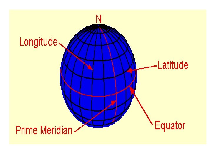
Latitude and Longitude Latitude is the distance of


- Slides: 27
Latitude and Longitude
Latitude is the distance of a point on Earth measured from north or south of the equator. 90 degrees north (North Pole) Equator 90 degrees south(South Pole)
Lines of Latitude cut through the earth to the middle, creating angles.
How Mr. Friesen remembers: • LATitude • LAT sounds like FLAT • So, “latitudes” are flat lines running around the Earth
All lines of latitude go around the Earth parallel to the equator. Finding the actual distance between the lines of latitude involves some large numbers.
• The actual distance around the Earth is 40, 000 kilometres. • To go from a pole to the equator is one quarter of the way around the Earth. • Therefore, the distance from the equator to either of the poles is approximately 10, 000 kilometres. • Because we know that the 90 degrees from the equator to the poles is 10, 000 kilometres, we can easily calculate the distance involved in one degree
If 90 degrees equals 10 000 kilometres, then one degree is 10 000 divided by 90. This equals about 110 kilometres. If 90° = 10 000 km then 1° = 10 000/90 km 1° ≈ 110 km
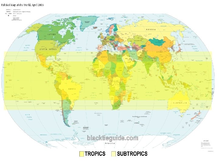
Special Lines of Latitude Because the Earth tilts on its axis, several lines of latitude have special characteristics. These are the two Tropics and the Arctic and Antarctic Circles
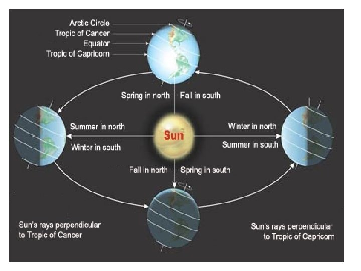
The Tropic of Cancer is 23½ degrees north of the equator, and the Tropic of Capricorn at 23½ degrees south of the equator. The 23½ degrees are the amount of tilt that the Earth has on its axis compared to the sun. This is why we have different seasons at locations away from the equator.
• On June 21, the sun is directly overhead at the Tropic of Cancer; on December 21, the sun is directly overhead at the Tropic of Capricorn.
As the Earth goes around the sun, the sun seems to migrate between the two tropics, crossing the equator twice—on March 21 and on September 21. In fact, the sun stays where it is and the orientation of the Earth changes as it revolves around the sun.
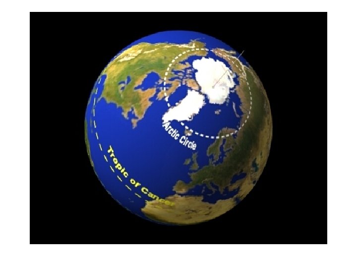
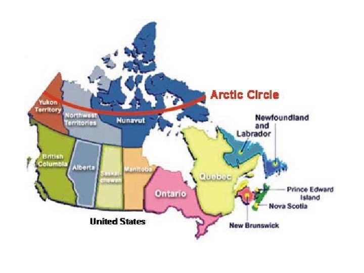
• The tilt of the Earth has a strange effect on the areas to the far north and the far south. • North of the Arctic Circle, located at 66½ degrees north, the sun is above the horizon for a full 24 -hour day during summer, and is below the horizon for a full 24 -hour day during winter. • The number of days of complete sunshine or complete darkness varies, depending on distance from the pole.
For example, 90°N undergoes six continuous months of daylight and then six continuous months of darkness, while 70°N undergoes only about two months of each. Canada’s Far North is sometimes called the “land of the midnight sun. ”
The location of the two “circles”—the Arctic and Antarctic—are also determined by the tilt of the Earth. We use the latitude of the North or South Pole (90°N or 90°S) and subtract the 23½ degree tilt of the Earth. That’s how we know where the circles are: 66½°N and 66½° S.
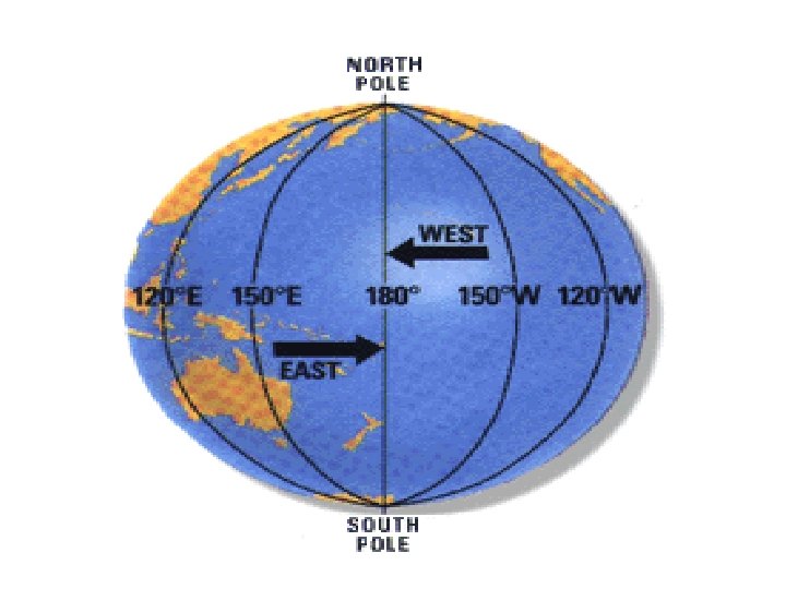
Longitude The lines connecting the two poles are known as lines of longitude, or meridians. They run north and south and always meet at the poles. Because they meet at the poles, the lines are not parallel. The distance between any two lines changes depending on the distance from the pole. The lines are farthest apart at the equator and closest together at the poles.
The Prime Meridian is the basis from which all lines of longitude are measured; the Prime Meridian is zero degrees longitude. The Prime Meridian does the same thing for longitude that the equator does for latitude. It runs through the Royal Observatory at Greenwich (in London, England), and is sometimes referred to as the Greenwich Meridian.
Longitude is measured in degrees. By definition, longitude is the distance of a point on the Earth’s surface measured east or west of the Prime Meridian. Because the Earth is 360° around, all meridians lie between 0° and 180° east or west of the Prime Meridian. At 180° east or west of the Prime Meridian is the International Date Line, which lies on the opposite side of the Earth from the Prime Meridian.
Specifying Locations Using Latitude and Longitude Can you find something if you only know the longitude? Can you find something if you only know the latitude? Why not?
With both latitude and longitude, you can find the exact location of any specific point on the surface of the Earth. The numbers for latitude and longitude are always given in the same order: latitude first and longitude second. As a result, the first figure given for the location of a place will have a north or south designation, and the second will have an east or west designation. For example, a mountain peak might be described as being at 51°N, 97°W.
Each degree of longitude can also be divided into minutes and seconds. For example, 49° 12' 30"E indicates that a location, perhaps a fishing cabin, lies along a line of longitude 49 degrees, 12 minutes, and 30 seconds east of the Prime Meridian. An exact location is always quite lengthy, such as 35° 24' 12"S, 25° 23' 1"W.
N N Northern hemisphere Southern hemisphere N Western Hemisphere S S S