Latitude and Longitude Latitude Imaginary horizontal lines that


- Slides: 14
Latitude and Longitude
Latitude • Imaginary horizontal lines that run across the earth. • They measure degrees north and south of the equator. • They’re called parallels because they never touch.
Important Lines of Latitude Equator • Most important • Located at 0° • Separates earth into north & south hemispheres (halves)
Important Lines of Latitude Tropic of Cancer • 23. 5° north • farthest point north that receives direct sunlight on or around June 21 st Tropic of Capricorn • 23. 5° south • farthest point south that receives direct sunlight on or around December 21 st
Important Lines of Latitude Arctic Circle Antarctic Circle • 66. 5° north • 66. 5° south
Rule of thumb • As a general rule, the farther north or south you go from the equator, the colder the climate.
Longitude • Imaginary lines that run up and down the earth but they measure in degrees east and west from the Prime Meridian. • Also known as meridians
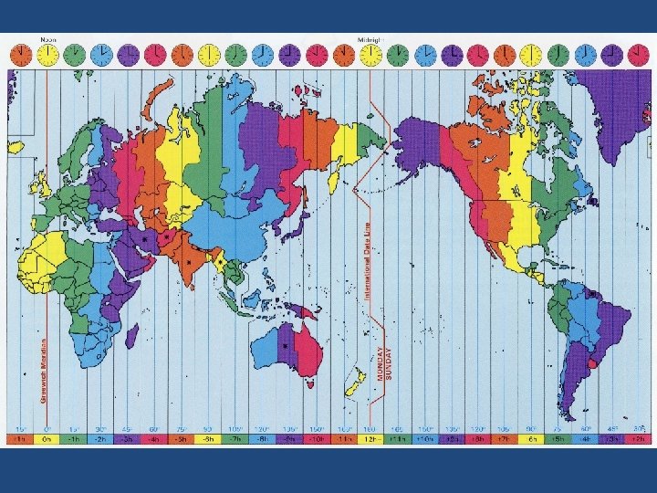
Important Lines of Longitude Prime Meridian • Most important line of longitude • Located at 0° longitude • Helps to separate the earth into the east & west hemispheres (halves) International Dateline • Located at 180° longintude • It is where the start of each new day begins
Rule of Thumb • Longitude lines have nothing to do with climate. • They are associated with time zones. About every 15° longitude is a new time zone.
Latitude & Longitude Rules 1. Find latitude first. a. Determine how far north or south of the equator the latitude is. b. Stay on the road!! Lines of latitude will curve because the earth is round. Trace the line of latitude at 45°N.
Latitude & Longitude Rules 2. Find longitude second. a. Determine how far east or west of the Prime Meridian the longitude is. b. Stay on the road!! Lines of longitude will curve because the earth is round. Trace the line of longitude at 75°W.
Latitude & Longitude Rules 3. Add tags. a. b. c. d. Latitude: N or S tag after it. Longitude: E or W tag after it. Remember degrees (°) after your numbers. Example, 41°N, 81°W. Look at a U. S. map. Which city has these coordinates?
Sample X X The red X is at 15°N, 30°E. What are the coordinates of the green X?