Latitude and Longitude LATITUDE Distance in degrees N


")
- Slides: 7
Latitude and Longitude
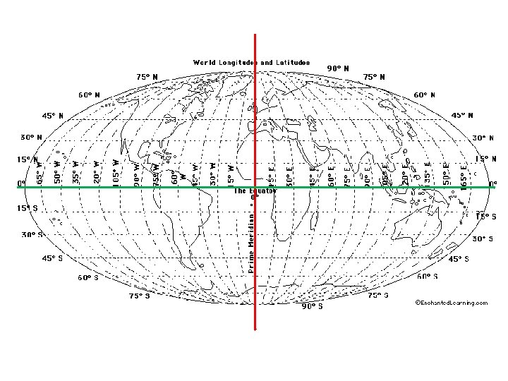
LATITUDE • Distance in degrees N and S of the Equator is like the x-axis on a graph • 00 = Equator • 900 = The Poles (90 N = North Pole, 90 S = South Pole) • Lines are parallel, no matter what kind of map you have; these lines never touch each other • 10 Lat = 111 km on Earth’s surface
Latitude of a Point on the Map 1. FIND LATITUDE a. follow the horizontal line and write that number. b. Then write N if the line is NORTH of the EQUATOR; write an S if it is SOUTH of the EQUATOR.
LONGITUDE • Distance in degrees E and W of the Prime Meridian It is like the y-axis on a graph • 00 = Prime Meridian • 1800 = Int’l Date Line • Lines are curved on a globe; these lines meet at the poles • Lines are straight/parallel on Mercator (rectangular) maps
Longitude of a Point on a Map 2. FIND LONGITUDE a. follow the vertical line and write that number. b. Then write an E if the point is EAST of PRIME MERIDIAN; write a W if it is WEST of the PRIME MERIDIAN
Time Zones • Time zones correspond to lines of longitude • (Along the Equator) 15° longitude = 1 hour • (From the Prime Meridian) Moving WEST you subtract an hour for each line of longitude; moving EAST you add an hour for each line of longitude • Earth has 24 lines of longitude, 24 hours in a day and 24 time zones. • (At the International Date Line) When you cross going EAST, you ADD a calendar day; going WEST, you SUBTRACT a calendar day.