Latitude and Longitude Cartography is the science of


- Slides: 49
Latitude and Longitude Cartography is the science of mapmaking. Cartographers use an imaginary grid of parallel lines and vertical lines to locate exact points on Earth. In cartography, parallels refer to lines of latitude. Lines of latitude, which encircle the earth along an east-west axis, are often referred to as parallels because they are perfectly parallel to one another. Unlike lines of longitude, which converge at the North and South Poles, lines of latitude never converge or intersect with one another Equator an imaginary line that circles the Earth halfway between the north and south poles. It is a line of latitude
Choropleth maps are thematic maps that employ a range of color tones to illustrate how particular values vary across predefined areas, such as counties, provinces, or states.
Contour Lines Contour lines are curves on a topographic map that are used to illustrate specific values of elevation above or below sea level. Topographical contours are typically irregularly shaped lines that connect points of equal elevation. Contour lines also illustrate the relative slope of elevation between various points. For instance, the slope between two points separated by only one or two contour lines Contour line - connects points of equal elevation. Contour lines NEVER CROSS because they connect points of equal elevation. Elevation- the distance above or below sea level.
Latitude Lines of Latitude Lines running parallel to the equator. Latitude- the distance in degrees north or south of the equator. Equator - 0˚ latitude
Latitude Poles - 90˚N and 90˚S Locations north of the equator are referred to by degrees north latitude (N). Locations south of the equator are referred to by degrees south latitude (S).
Latitude Each degree of latitude equals 111 km on Earth’s surface. How do they know that? Earth is 40, 000 km in circumference. Divide 40, 000 by 360˚ 111 km
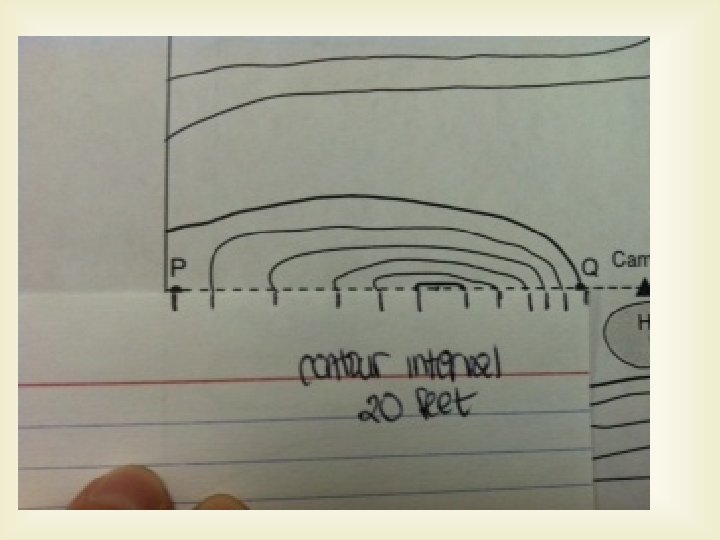
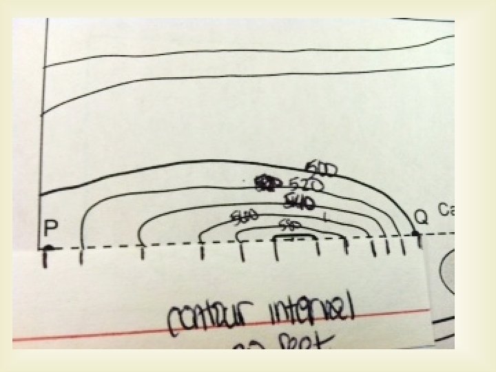
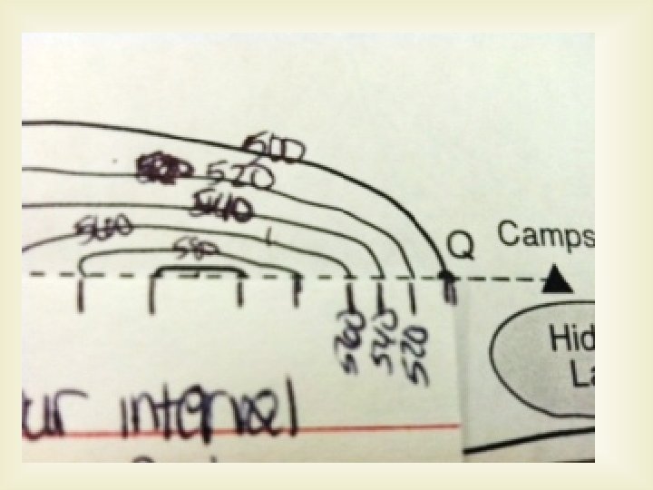
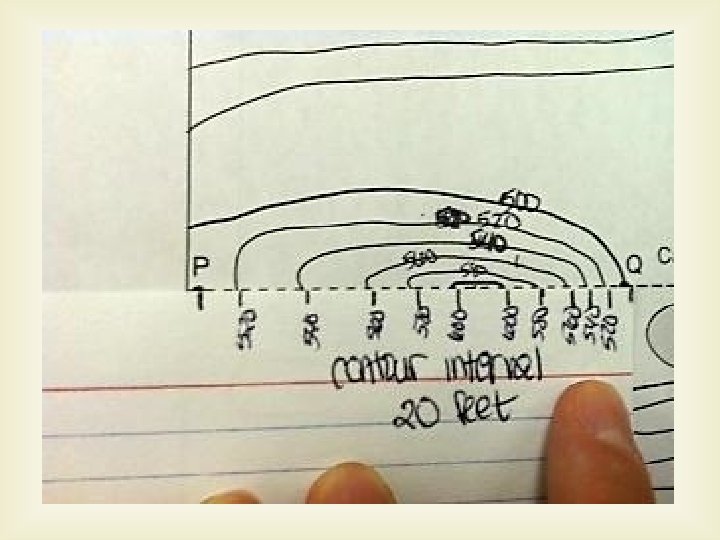
Contour Line Terms Contour Interval- difference in elevation between two side-by-side contour lines. Index Contours- marked by numbers representing their elevations. Depression Contour Lines- dashes inside a contour line that represent a lower elevation than the surrounding landscape.
Longitude Lines of longitude mark locations in east and west directions. Prime Meridian the reference point for longitude. 0˚ longitude
Longitude Prime Meridian goes through Greenwich England Semi Circles- lines of longitude are NOT parallel. Vertical Lines
Spain and Morocco are the only states that possess territory located along the Strait of Gibraltar. The Strait of Gibraltar is a narrow oceanic waterway that links the Atlantic Ocean, to the west, with the Mediterranean Sea, to the east. It also separates Spain, to the north, from Morocco, to the south
Coordinates Both latitude and longitude are needed to precisely locate positions on Earth. Coordinates: (degree latitude, degree longitude) North or South East or West
Bedford, VA 37˚ 20’ N, 79˚ 31’ W Latitude Longitude
Latitude and Longitude Detail Latitude Detail Longitude Picture
Question of the Day September 1, 2011 Maps are flat models of a 3 -D object, Earth. However, Earth is curved, so it is difficult to represent on a flat piece of paper. What kind of effect do you think this has on maps of the Earth?
Types of Maps Since Earth is a sphere, it is difficult to represent on a flat piece of paper. Distortion: So, all flat maps distort either the shapes or the areas of landmasses.
Types of Maps Projections A map projection is made by transferring points and lines on a globe’s surface onto a piece of paper. 3 types of Projections: 1. Mercator Projection 2. Conic Projection 3. Gnomonic Projection
Mercator Projections Mercator Projections- a map that has parallel lines of latitude AND longitude. (BTW- lines of longitude aren’t actually parallel, they cross at the poles) In effect: correct shapes of landmasses, but areas are distorted Used for: navigation of planes and ships.
Mercator Projection
Conic Projections Conic Projection – made by projecting points and lines from a globe onto a cone. The cone touches the globe at a particular line of latitude. In effect: little distortion along that line of latitude, but a lot of distortion near top and bottom. Excellent for mapping small areas. Used for: road maps and weather maps.
Conic Projection
Gnomonic Projections Gnomonic- paper touches globe at a single point. In effect: direction and distance between landmasses are both distorted. Used for: planning long distance trips by air and by sea. -Great Circles
Gnomonic Projections
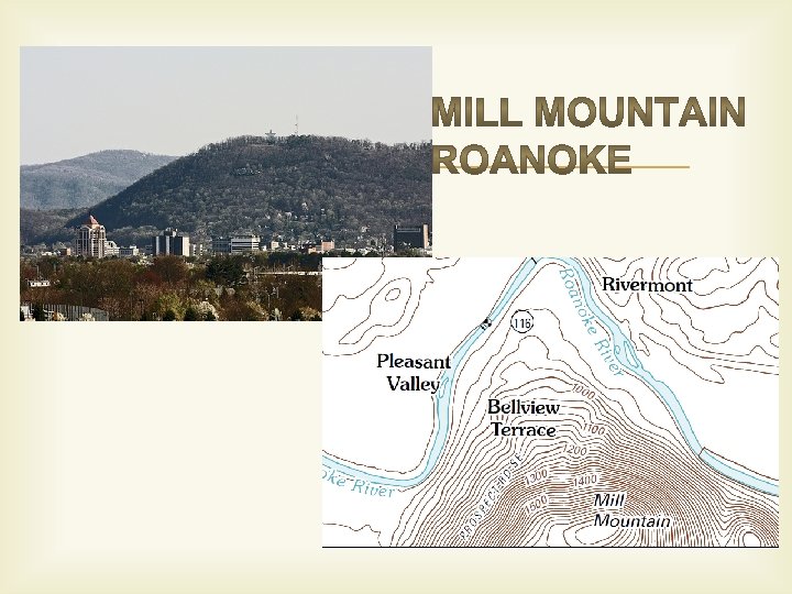
Topographic Maps Detailed maps showing the hills and valleys of an area. Show changes in elevation. Also show mountains, rivers, forests, bridges…etc Use lines, symbols, and colors to represent changes in elevation and features on Earth’s surface.
Topographic Maps What do these three maps have in common?
More mapping terms Map legend- explains what symbols represent Map scale- the ratio between distances on a map and the actual distances on Earth.
Organize Information Make a mind map for the three types of map projections.
1. What type of map is pictured below? 2. What are the lines on the map called?
Identifying topographic features Steep Slopes: contour lines are very close together, indicating a quick change in elevation.
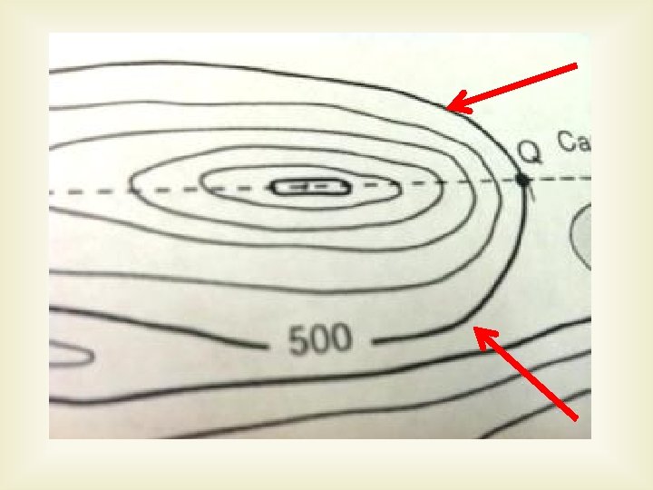
Hills Hills- usually one complete contour line within a small area, or a circle, marking the top of a hill.
2 hills Sometimes two hills are connected by a saddle, and there are two distinct hills with contour lines surrounding them at their bases.
Stream Flow The direction of stream flow can be identified by looking at “V”s in the contour pattern. The V’s always point UPSTREAM. This stream is flowing south west, and then south
Stream Flow. W What direction is this stream flowing? ______ N E S
Topographic Map Reading 1. What is the latitude of the north end of Blue Lake? Use degrees and minutes. 2. What is the contour interval of the map? 3. What is the elevation of the top of White Mountain? 4. How many mountains are within the map? 5. In what range of elevations is the town of Dixon? 6. About how many miles across is the map? 7. What is the copyright of the map?
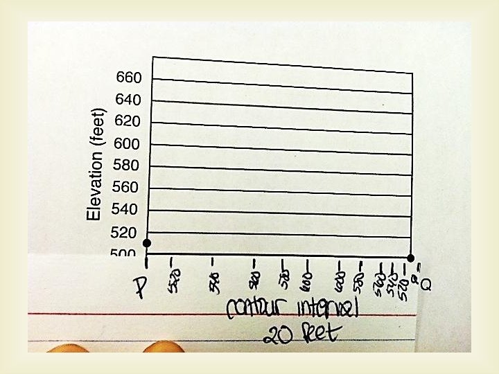
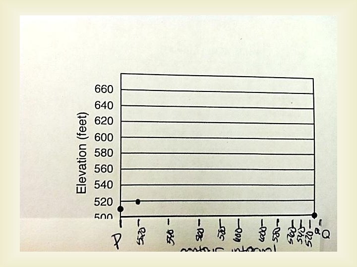
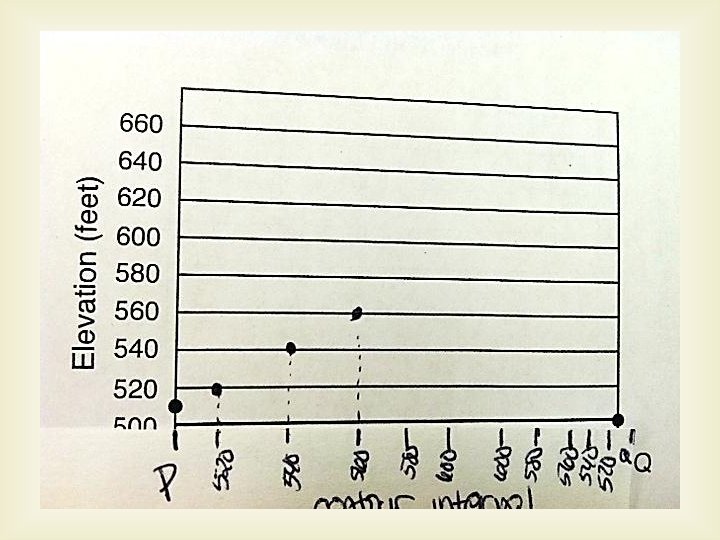
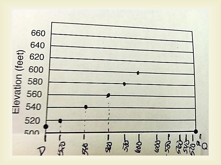
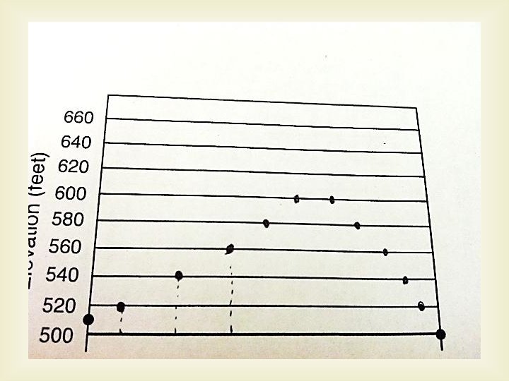
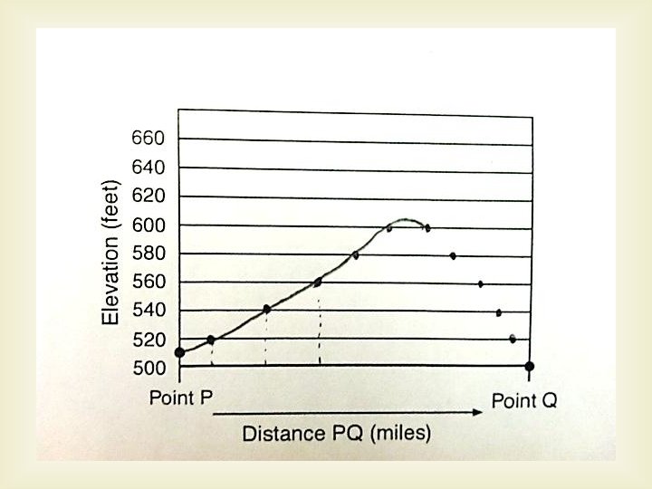
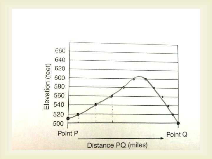
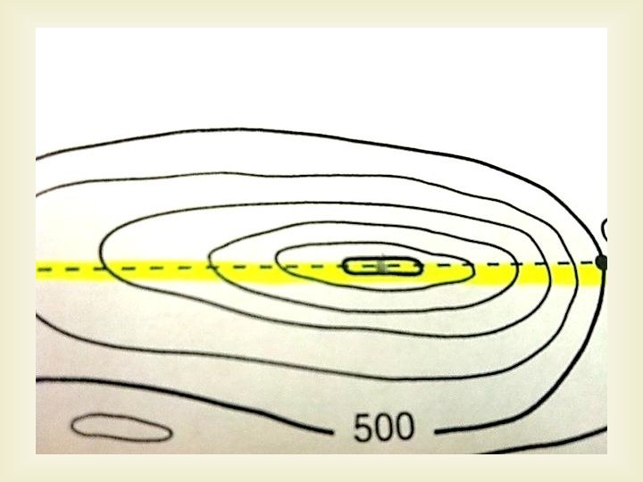
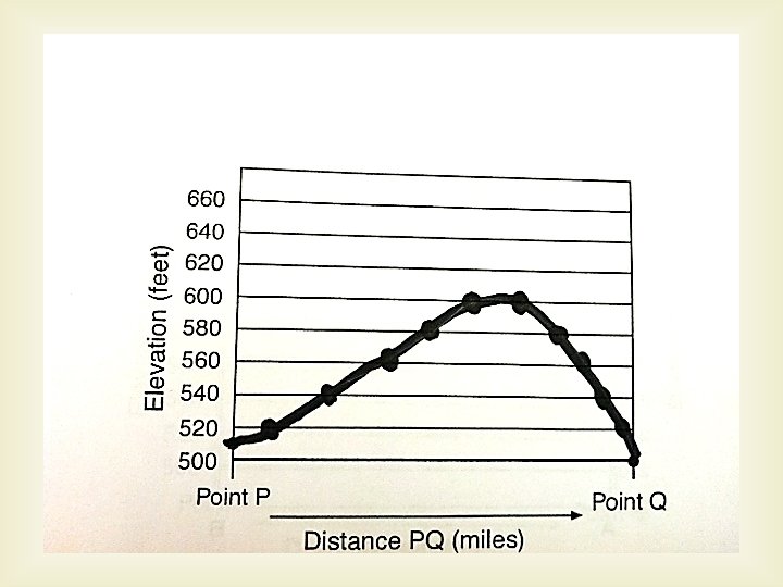
Creating a Landscape Profile