LATIN AMERICA PHYSICAL LANDFORMS Land Bridge a strip

LATIN AMERICA- PHYSICAL

LANDFORMS � Land Bridge- �a strip of land that connects two larger landmasses, enabling migration of plants and animals to both areas. � Ring of Fire- Western Mexico is part of ring of fire.

WATER SYSTEMS � Northern Mexico- has a dry climate with few permanent water ways � Lerma River- Mexico’s most important river � Gulf of Mexico � Gulf of California

CLIMATE, AND BIOMES � Three factors influence Mexico’s climate: � Regional high-pressure systems � Northeast trade winds � Vertical climate zones- occur as elevations increase � Mexico has a variety of biomes

MEXICO’S ECONOMY- NATURAL RESOURCES � Silver and other minerals � Leading petroleum-producing country

Central America

LANDFORMS � Central America has three distinct belts: � Pacific Lowlands � Caribbean Lowlands � Central Highlands � 7, 000 islands are considered part of the mainland’s Central Highlands � Isthmus � it of Panama connects North and South America and separates the Caribbean Sea (Atlantic Ocean) from the Gulf of Panama (Pacific Ocean)

= Central Highlands Caribbean Lowlands Pacific Lowlands

WATER SYSTEMS � Inland lakes and waterways are important to Central America's growth and development � providing transportation � drinking water � irrigation � hydroelectric power � Commercial fishing and the use of other marine resources in the Caribbean Sea have increased international trade.

WATER SYSTEM � Panama � Human � Canal made allows ships to travel between the Atlantic and Pacific Oceans without having to travel around South America's Cape Horn

CLIMATES � Much of Central America has a tropical wet climate with rainforests found in many of the regions � A tropical dry climate is found on many of the Caribbean Islands � The climate and ecosystems of some parts of central America are affected by elevation.

RESOURCES � Nickel � Iron ore � Fish � Timber � Petroleum

South America

LANDFORMS � South America’s diverse landscape is marked in the west by the high peaks of the Andes and in the east by broad plateaus and valleys. � The cordillera established natural boundaries that resulted in the development of isolated groups.
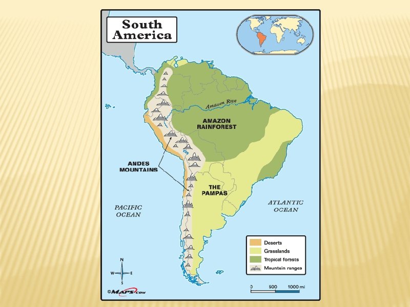

LANDFORMS CONTINUE � Narrow coastal lowlands rim the Atlantic and the Pacific coasts. � Inland grasslands like the llanos and the pampas provide fertile soil and plains for cattle to graze.

WATER SYSTEMS � The Amazon flows 4, 000 miles through the heart of South America and is its longest river. � Hundreds of smaller rivers join the Amazon to form the Amazon Basin.

WATER SYSTEMS � The Parana, Paraguay, and Uruguay Rivers drain the rainy eastern half of South America. � The Pantanal is the world’s largest tropical wetlands. � Lake Maracaibo and Lake Titicaca are South America’s largest lakes

CLIMATES, BIOMES AND RESOURCES � Diverse climates make South America a region of contrasts. � El Niño affects the climate in South America by creating unusually warm ocean currents, and can have negative effects on � Coastal weather � Fishing � Agriculture

NATURAL RESOURCES � The physical geography dictates each country’s access to natural resources.

AMAZON RAINFOREST � The Amazon Rainforest shelters more species of plants and animals than anywhere on earth. � The Lungs of The Planet
- Slides: 22