Latin America Physical Geography This is Latin America


: 6, 962 m (22, 841 ft) Located in Argentina, right along")


")


- Slides: 74
Latin America Physical Geography
This is Latin America is NOT a continent. Latin America is NOT a country. Latin America IS a cultural region.
Latin America stretches for 5, 500 miles from the Rio Grande River in Mexico to Cape Horn at the southern end of South America.
Subregions There are two sub-regions of Latin America. “MIDDLE AMERICA” -Mexico -Central America countries -Island nations in the Caribbean SOUTH AMERICA -12 countries -2 foreign ruled territories
Physical Features of Latin America and the Caribbean • Latin America includes Mexico, Central America, and South America • The islands of the Caribbean are also considered to be part of Latin American • The region is called Latin America because the languages spoken there (mostly Spanish & Portuguese) developed from the Latin language. • It has an area of 8 million square miles which is nearly 16 percent of the Earth’s surface.
Most of the Latin America is made up of mountains or highlands. HIGHLANDS – A mountainous or hilly section of a country MOUNTAINS – land that is at least 2000 ft. high
Latin America lies between the Pacific and Atlantic oceans. Both oceans are important trade routes for Latin America. The Caribbean Sea is another important body of water in Latin America. CARIBBEAN SEA ATLANTIC OCEAN PACIFIC OCEAN Label on your map: 4. Caribbean Sea 16. Pacific Ocean 17. Atlantic Ocean
The Caribbean Sea • An arm of the Atlantic Ocean • Located between Cuba and South America • Islands in the Caribbean Sea are popular tourist destinations because of their beautiful beaches and mild tropical climate.
Caribbean Sea
Caribbean Islands • How were the Caribbean Islands formed? What are they? • They were formed by volcanic activity. They are peaks of volcanoes and some are active. • Can be a hazardous place to live.
Countries of the Caribbean • Cuba • Haiti • Dominican Republic • Jamaica and • Puerto Rico (US)
Cuba Label #2 Cuba on your map.
Haiti Label # 3 Haiti on your map.
Gulf of Mexico • Another arm of the Atlantic Ocean • Cradled by Mexico and the south U. S. coastline from Texas to Florida • The Mississippi River and Rio Grande are two major rivers that empty into the gulf. Label # 1 The Gulf of Mexico on your map.
Mexico Label # 14 Mexico on your map.
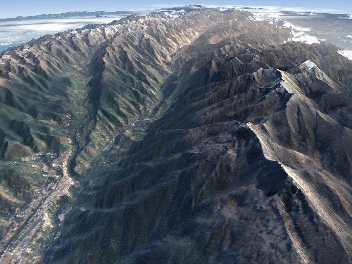
SIERRA MADRES Label # 15 The Sierra Madres on your map In Mexico the Sierra Madres mountains split into the Sierra Madre West and Sierra Madre East. SIERRA MADRES EAST SIERRA MADRES WEST
Sierra Madres
Sierra rocky cliffs
Green slopes
Looking across the range
The Sierra Madres, Mexico
Countries of Central America • Belize, Guatemala, El Salvador, Honduras, Nicaragua, Costa Rica, Panama
Costa Rica Label # 13 Costa Rica on your map.
Panama Label # 12 Panama on your map.
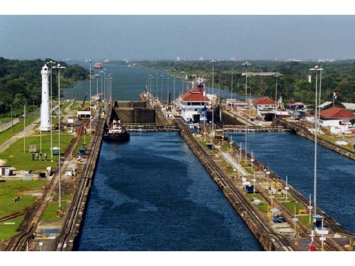
The Panama Canal
What is the purpose of the Panama Canal? • Allows ships to travel between the Atlantic and Pacific Ocean without sailing around the Southern tip of South America
Going Through the Panama Canal
https: //www. youtube. com/watch? v=-vi 19 z 4 LEi 0&src_vid=f. Apn. N 54 u. Pw&feature=iv&annotatio n_id=annotation_322604
Equator Draw the equator on your map.
Countries of South America • Colombia, Venezuela, Guyana, Suriname, French Guiana, Ecuador, Peru, Bolivia, Brazil, Paraguay, Argentina, Chile, Uruguay
Colombia Label # 11 Colombia on your map.
Venezuela Label # 5 on your map.
Brazil Label # 7 Brazil on your map.
Bolivia Label # 8 Bolivia on your map.
Elevation and the Andes • The major mountain range of Latin America begins in The United States as the Rocky Mountains, continues through Mexico where it is known as the Sierra Madres and Central America where it is called Central Highlands and down through South America where the mountain range is called The Andes.
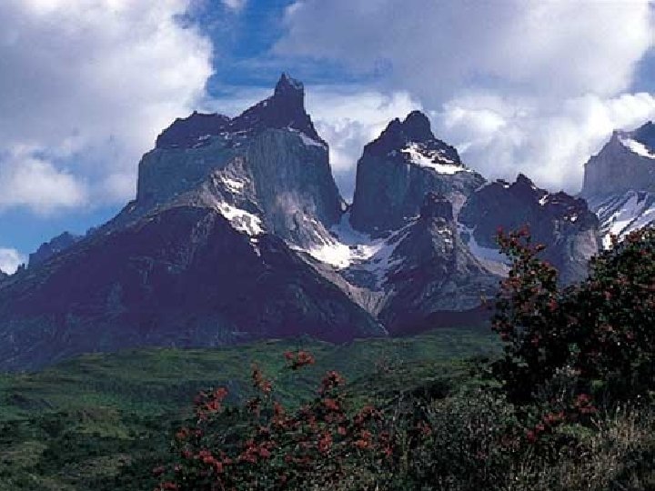
UNT O ES M AND The Andes are the longest mountain range in the world and the 2 nd highest mountains in the world. AINS Label # 10 The Andes Mountains on your map.
The ANDES Mountains • Stretch for 4, 500 miles along the western edge of South America. • They are the world’s longest mountain chain, with peaks of more than 20, 000 feet. • A unique feature is the cordilleras, several ranges that run parallel to one another.
Aconcagua (South America): 6, 962 m (22, 841 ft) Located in Argentina, right along it’s border with Chile, tallest peak outside of Asia
ANDES
Peaks in the ANDES
Looking up
Andes Mountains (Peru)
The Eastern Flank of the Andes
Llamas in the Andes
Population in the Andes • Why do people live in the mountains and plateaus of Latin America? • Cooler climates, rich natural resources (water, volcanic soil, timber and minerals)
http: //app. discoveryeducation. co m/player/view/asset. Guid/D 2813 C C 3 -79 E 2 -4777 -92 EA 2 C 899103 C 4 FD
In South America is the driest desert in the world. It is sheltered from the rainforest by the Andes Label # 9 The Atacama Desert on your map. A tac am Dese a rt Deserts
Atacama Desert, Chile The Atacama is one of the driest places on Earth. In some parts no rain has fallen for 400 years.
Atacama Desert
Atacama
http: //app. discoveryeducation. co m/player/view/asset. Guid/58 DF 661 1 -4 F 51 -4 E 32 -ABDF-01 CB 76278212
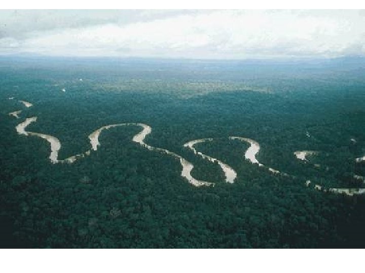
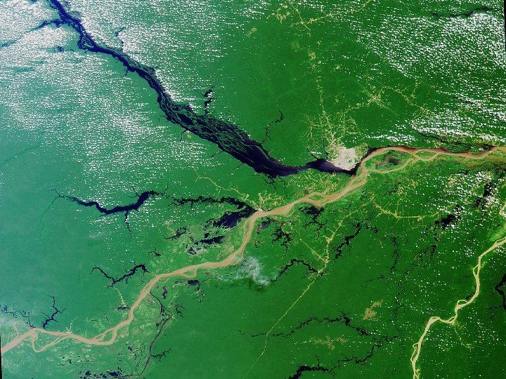
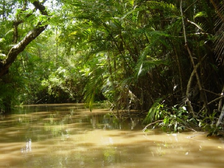
The Amazon River • Flows from the Peruvian Andes to the Atlantic coast of Brazil. • 4, 000 miles long and the longest river in the Western Hemisphere (world’s 2 nd longest) • 10 times the water volume of the Mississippi.
AMAZON RIVER The Amazon is the largest river in the world. It begins in the Andes Mountains in Peru and flows east across Brazil.
Label # 6 – The Amazon River on your map.
Amazon flowing through the rainforest.
http: //app. discoveryeducation. co m/player/view/asset. Guid/561 B 4 D B 3 -58 A 2 -457 A-9 FDAD 676 D 753 EC 4 E
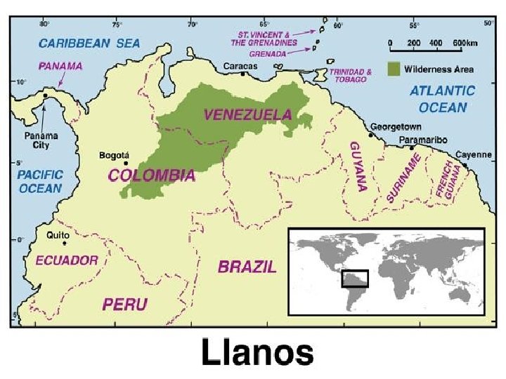
Grasslands • Llanos • Pampas –In Venezuela –In Argentina –Used for grazing and farming
LOWLANDS PAMPAS One kind of lowland area in Latin America is pampas. The pampas are grassy plains that stretch from Argentina into Uruguay. The pampas are a productive farming region.
Cattle on the Pampas
Cattle Ranching on the Pampas
Gauchos of the Pampas, Argentina
Orinoco Lowlands, the Llanos
Shade trees on the llanos
A small pond on the llanos
Lllanos and Pampas • Where are the llanos and pampas? What are the regions used for? • They are inland grasslands. • Llanos-Colombia and Venezuela • Pampas- Argentina and Uruguay • Used for grazing cattle.
WHY is it called Latin America? a language • Latin is • The two widely spoken languages are Latin-based And Spanish Portuguese is spoken in Brazil just about everywhere else!!!