Latin America Chapter 9 Physical Geography Latin American


 • Copper • Tin • Iron")


- Slides: 39
Latin America Chapter 9 Physical Geography
Latin American Regions • Middle America – includes Mexico and the Central American countries • The Caribbean Islands • South America
Landforms • Mexico – Sierra Madre Oriental & Occidental Mountains – Anáhuac – densely populated plateau Oaxaca Plateau, Mexico
Sierra Madre Ranges
Andes Mountains • Longest mountain range in the world • Stretches 4, 500 miles from north to south, along the west coast of South America • Highest peak, Aconcagua, rises 23, 000 feet Aconcagua
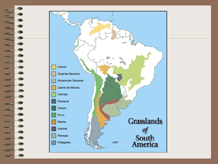
Landforms PLAINS • Llanos - vast tropical grassland plain situated at the east of the Andes in Colombia & Venezuela (cattle ranching) • Pampas - fertile plains in Argentina, Uruguay, & Brazil (grain, cattle, & sheep) PLATEAUS • Patagonia – cold, windswept plateau in Argentina & Chile • Altiplano – high plateau in Chile, Argentina, Bolivia & Peru
Atacama Desert • Located in Chile and Peru • Driest desert on Earth • Rich deposits of copper and other minerals
Amazon Rainforest South America • Covers 1. 2 billion acres • More than 1/5 of the rainforest has already been destroyed • One square kilometer of the Amazon rainforest can contain about 90, 000 tons of living plants.
Amazon Rainforest • The region is home to 2. 5 million insect species, tens of thousands of plants, and some 2, 000 birds and mammals. Tapir Orchid
Amazon River • Longest River in the Western Hemisphere • Greatest total water flow of any river, carrying more than the Mississippi, Nile, and Yangtze rivers combined • Drainage area, called the Amazon Basin, is the largest of any river system Amazon River near Manaus
Amazon River
Amazon River
Amazon River
Paraná, Paraguay, & Uruguay River System • 2 nd longest river system in South America • Most important commercial highway Rio Parana from Encarnacion, Paraguay, looking to Posadas, Argentina
Orinoco River • Mainly in Venezuela • More that 1, 500 miles long into the Atlantic • Some of the areas drained by the Orinoco are home to the few remaining Native American peoples, such as the Yanomamo
Amazon River Dolphin • Found in the Amazon and Orinoco Rivers • 1 of 5 freshwater dolphin species in the world • Unique pink coloring • Also known as “Boto”
Lake Titicaca • Highest commercially navigable lake in the world (12, 536 ft. above sea level) • South America’s largest freshwater lake • Located in the Altiplano high in the Andes on the border of Peru and Bolivia
Lake Maracaibo • Located in Venezuela • Contains large reserves of crude oil • Connected to the Gulf of Venezuela by a narrow strait in the north, making it slightly saline
Lake Nicaragua • Largest lake in Central America • Located in Nicaragua • Called “The Sweet Sea” • Has sizeable waves and archipelagos of islands • Lake Nicaragua has the only species of freshwater sharks in the whole world.
Angel Falls • World’s highest uninterrupted waterfall at 3, 230 feet • Located in Venezuela • The waterfall was not known to the world until its official discovery in 1933 by the American aviator, James Crawford Angel, on a flight while searching for gold. • 16 times the height of Niagara Falls
Angel Falls
Major Islands • Greater Antilles – Large islands in the Caribbean – Cuba, Jamaica, Hispaniola (Haiti & Dominican Republic), Puerto Rico • Lesser Antilles – Smaller islands in the region SE of Puerto Rico – Divided into the Windward (winds that blow across them) and Leeward (sheltered) Islands
Greater Antilles
Lesser Antilles
Mineral Resources • Bauxite (used to make aluminum) • Copper • Tin • Iron • Lead • Nickel • Silver • Gold Bauxite
Energy Resources • • • Oil – Venezuela & Mexico Coal Natural gas - Trinidad Uranium Hydroelectric power - Brazil
Hydroelectric power plant in Brazil
Varied Climate & Vegetation • Varied climate and vegetation due to several factors: – Spans a great distance on each side of the equator – Big changes in elevation because of massive mountains – Warms currents of the Atlantic Ocean & the cold currents of the Pacific Ocean affect the climate
Tropical Climate Zones • Tropical Wet – Rain forests – Hot and rainy year round – Most of Brazil • Tropical Wet & Dry – Savannas – Hot climates with seasonal rains – Found of Brazil, Colombia, & Argentina
Dry Climate Zones • Desert – Less than 10 inches of precipitation a year – Northern Mexico, coast of Peru, Atacama Desert in Chile, part of Patagonia • Semiarid – Generally dry, with some rain – Parts of Mexico, Brazil, Uruguay, & Argentina
Mid-Latitude Climate Zones • Humid Subtropical – Rainy winters and hot, humid summers – Varied vegetation – Parts of Paraguay, Uruguay, southern Brazil, southern Bolivia, and northern Argentina • Mediterranean – Hot, dry summers and cool, moist winters – Chapparal vegetation – Located in part of Chile • Marine West Coast – Cool, rainy winters and mild, rainy summers – Forests – Southern Chile & Argentina • Highlands – Moderate to cold, depending on elevation – Mountains of Mexico & South America
Human/Environment Interaction • • Slash-and-Burn farming Terraced farming Urbanization Tourism
Slash-and-Burn Farming - Used by native peoples to clear fields - Cut trees, brush, grasses and burned the debris to clear the field • Today, farmers practice this method to clear land for farming in the Amazon River basin • Sometimes use destructive farming practices • Soil is exhausted after a few years and all nutrients have been drained from the soil • Then they move on and clear another spot • This is one of the reasons for the shrinking of the rainforest
Before & After
The aftermath of slash and burn farming in the Amazon.
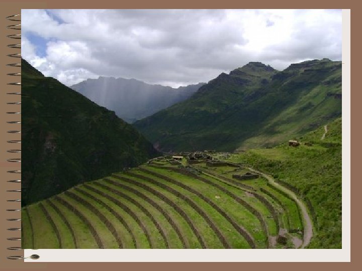
Terraced Farming • Ancient technique for growing crops on hillsides or mountain slopes • Cut step-like horizontal fields into hillsides and slopes • Allow steep land to be cultivated for crops • Reduces soil erosion
Tourism • Advantages of Tourism – Create jobs • Disadvantages of Tourism – – Congestion Pollution Income gap between tourists and local residents Public debt due to borrowing money to build tourist facilities – Often, the owners of the hotels and airlines do not live in the country and the profits go elsewhere