Landforms Unit Standards 5 E 3 A 1


- Slides: 12
Landforms
Unit Standards 5. E. 3 A. 1 Construct how different landforms and surface features result from the location and movement of water on Earth’s surface through watersheds (drainage basins) and rivers. 5. E. 3 A. 2 Develop and use models to describe and compare characteristics and locations of the landforms on continents with those on the ocean floor (including the continental self and slope, the mid ocean ridge, the rift zone, the trench, and the abyssal plain). 5. E. 3 B. 1 Analyze and interpret data to describe and predict how natural processes (such as weathering, erosion, deposition, earthquakes, tsunamis, hurricanes, or storms) affect Earth’s surface.
How are Earth’s features mapped? • Surveyor- a person who takes measurements of the land.
How are Earth’s features mapped? • Elevation- the height of land above the sea level
How are Earth’s features mapped? • Benchmark- a permanent reference point for a particular elevation
How are Earth’s features mapped? • The first step in making a map is measuring the elevation. • Map makers use the surveyor’s measurement to show changes in elevation on the map. • One way to do this is to draw a shaded picture of the land. • The shading makes the map look like it has three dimensions: length, width, and height.
How are Earth’s features mapped? • Relief Map- a map that uses shading to show elevations.
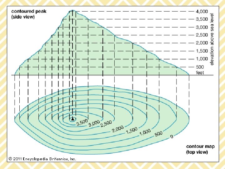
How are Earth’s features mapped? • Topographical Map- uses lines to show the elevation
How are Earth’s features mapped? • Contour Lineslines on a topographical map to show elevation. The number on the line gives the elevation. It is given in units of feet or meters.
How are Earth’s features mapped? • Contour lines can also tell you how steep or gradual a slope is. • Contour lines that are close together means the elevation is changing rapidly and the slope of the land is very steep. • Contour lines that are far apart mean the elevation is changing gradually.