Land use and land cover change with special


 DATA USED Raster data: www. lsgd. kerala. gov. in/htm/main.")


 International journal for research and development. They have been")

- Slides: 22
“Land use and land cover change with special reference to the paddy field” in Mundur Grama panchayat in Palakkad district of Kerala Rajan. M- Integrated Rural Technology Centre, Palakkad Prem. V - - Care Eartb Trust, Chennai
Introduction ØLand use is defined as the land put under use ØThe Land cover reflects the biophysical state of the Earth surface including the soil material, vegetation and water. ØMundur Panchayat of Palakkad district has witnessed a remarkable expansion, growth and development activities such as building road construction etc, . and many other anthropogenic activities. Since the construction NH 213 the development is taking place rapidly. This has therefore resulted in increased consumption and a modification and alterations in the status of landuse and land cover time. For ensuring planned development and monitoring the Land utilization pattern, preparation of Land use and Land cover map is necessary.
Objectives of the study § To analyse the spatio-temporal variation of Mundur Panchayt for the year 2004 and 2014. §To analyse landuse change of the study area specially focused on paddy field.
Need for the study §Paddy field is basically a natural reservoir and allow rain water to enter in to ground and increases the ground water level §Paddy field is a type of wetland ecosystem which is the food source for birds. §During winter season migration birds from various countries and other parts of world arrive for food resource.
Limitation of the study ØThis project mainly based on secondary data availed from various sources ØThe study carried out on the basis of satellite imagery of 30 meter spatial resolution. ØLimited time to prepare report and analysis.
METHODOLOGY (DATA, METHODS & TECHNIQUES) DATA USED Raster data: www. lsgd. kerala. gov. in/htm/main. php-Kerala boundary LSGD Maps for Panchayat earthexplorer. usgs. gov/ -Landsat-30 meter spatial resolution for 2004 and 2014. bhuvan. nrsc. gov. in/ -Cartosat-1 2. 5 meter spatial resolution Vector data: - www. openstreetmap. org -for obtaining District boundary. Other data: -Reports, Journals, magazines, census. Open Source Software: Quantum GIS 2. 8, Multi. Spec 3. 4, ELWIS 3. 3
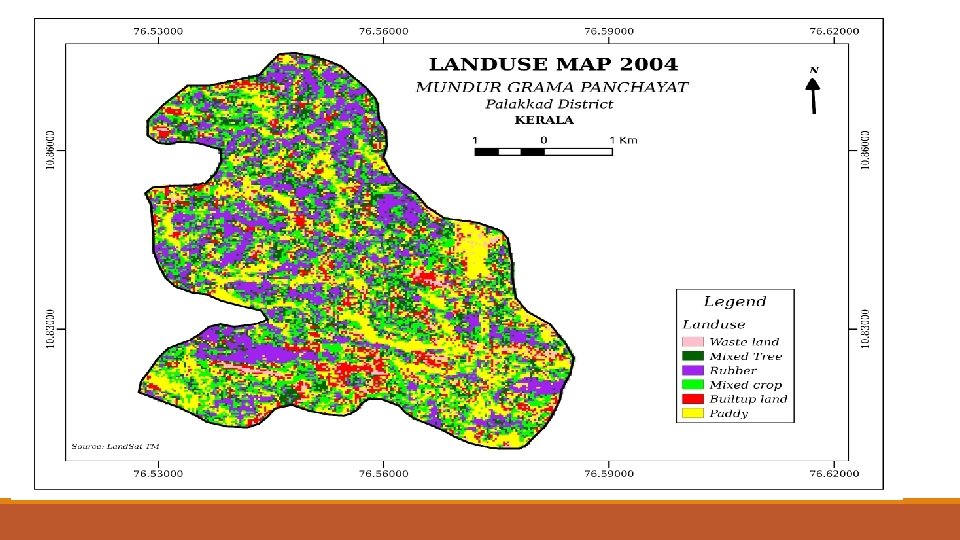
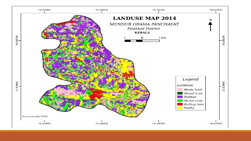
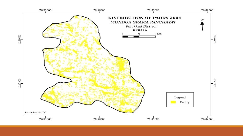
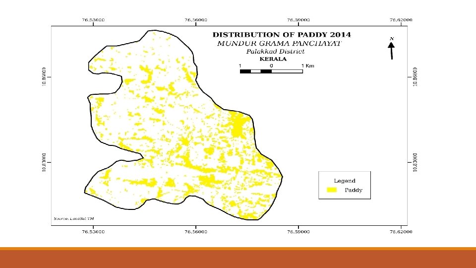
LANDSAT IMAGE 2004 LANDSAT IMAGE 2014 DIGITAL IMAGE INTERPRETATION LAND USE MAP 2004 LAND USE MAP 2014 CHANGE DETECTION
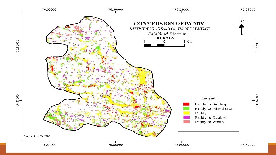
METHODS & TECHNIQUES §Review of prior work was carried out to have a clear knowledge about the landscape of the place. §satellite data was downloaded for the year 2004 and 2014. §Clipping technique was used to subset the study area from the false colour composite of satellite data. §Digital Super-vised classification technique was carried out to demarcate the landuse and landcover of Mundur Panchayat. §Area of both the output calculated and compared to find out the ratio between the landuse map of 2004 and 2014 respectively. §Overlay analysis technique was carried out to find out which area of paddy is converted to other crops or plantations. §On the basis of the result obtained from the above analysis management plan was discussed.
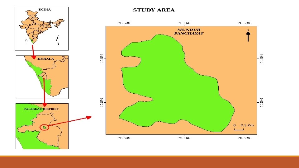
Study area – Mundur Grama panchayath ØArea: 28. 77 sqkm. ØLat: 10˚ 48’ 36” to 10˚ 52’ 36”N ØLong: 76˚ 31’ 38” to 76˚ 35’ 09”E ØPhysiography: Midland ØClimate: South West Mansoon and North East mansoon influencing. (Annual Rainfall-211 cm) ØDemography –Total population: 30648 (2011 census), Density-787 person/sqkm ØSoil: Alluvial and Laterite soil ØLanduse classes: Paddy, Mixed crop, Mixed tree, Rubber, Waste land Paddy converted in to other crops ØRice Variety: Palakkad matta (Thavalla Kannan & Chenkazhama etc)
Analysis
LANDUSE CHANGE 2004 -2014 35, 00 28, 58 28, 84 30, 00 25, 00 20, 00 30, 51 24, 99 22, 96 19, 85 14, 23 15, 00 10, 00 7, 29 6, 81 5, 56 6, 70 3, 70 5, 00 0, 00 Paddy Mixed Crop Mixed Tree 2004 % Waste Land 2014 % Rubber Builtup Land
Why- Paddy reclamation ØShortage of Labour ØLow rainfall ØHigh cost of production ØFrequent crop failure
Consequences ØScarcity of drinking water ØGround water depletion-Drying up of wells ØPaddy cultivating area has shrinked ØProduction reduced ØReduced the local birds and migratory birds in number
Paddy and birds ØBirds are the important components of our ecosystem and play a major role in maintaining the natural Ecosystem. ØTo balance of food chain. Birds are excellent indicators of environmental health and their changing populations often provide clues to the health of their habitats. Ø Paddy fields are the main food source for the bird community ØUsually most of the birds are visits to paddy fields foraging, nesting and breeding during the period of growing stages of paddy and its harvesting stage. Ødeclining of huge number of birds through affect their breeding, laying and hatching of eggs.
References 1. Priyadharshini. J, (2013) International journal for research and development. They have been found study of land use/ land cover change using GIS technique in Tiruchirappalli district of Tamil Nadu 2. Rajeshkumar (2013) Journal of Aquatic Biology and Fisheries Vol. 2/2014/ pp. 522 to 533 Land-use change pattern and bird diversity of puliyampully watershed, mundur grama panchayath, palak. kad, kerala 3. Dr. R. Ravikamar and Suddeesh. B (2013) EPRA International journal of economic and Business review- online journal: Economies of Paddy cultivation in Palakkad district of Kerala.
Thank You