KTH ROYAL INSTITUTE OF TECHNOLOGY Earth Observation for

KTH ROYAL INSTITUTE OF TECHNOLOGY Earth Observation for Mapping & Monitoring Urban Expansion, Green Structure & Slums Yifang Ban, Professor Director, Division of Geoinformatics Vice Chair, Department for Urban Planning and Environment KTH Royal Institute of Technology Stockholm, Sweden

Urban SGD Target 11. 3: : By 2030, enhance inclusive & sustainable urbanization and capacity for participatory, integrated and sustainable human settlement planning and management in all countries. Indicator 11. 3. 1 The Ratio of land consumption rate to population growth rate –Land use efficiency

Satellite Data

Sentinel-1 A/1 B SAR & -2 A MSI Data

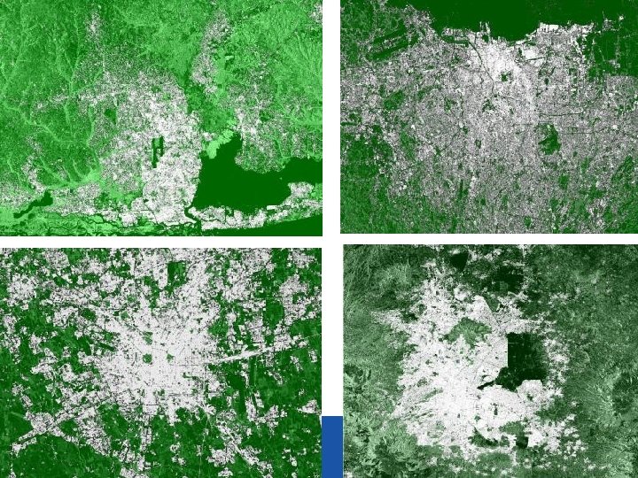
Study Areas

Sentinel-2 A MSI & -1 A SAR Data

Sentinel-2 A MSI Data

Sentinel-1 A SAR Data

KTH-SEG: Edge-Aware Region Growing & Merging Algorithm Ban, Y. and A. Jacob, 2013. Object-based Fusion of Multitemporal Multi-angle ENVISAT ASAR and HJ-1 Multispectral Data for Urban Land-Cover Mapping. IEEE Transaction on Geo. Science and Remote Sensing, Vol. 51, No. 4, pp. 1998 -2006.

Stockholm Urban Extraction Using KTH-Pavia Urban Extractor Results: Stockholm

Urban Extent Extraction: SAR

Accuracy Assessment: Stockholm

13

14/02/17 14

14/02/17 15

Accuracy Assessment: Beijing

17

18

Accuracy Assessment: Milan 14/02/17 20

Urban Extraction with Sentinel-2 A & Fusion of Sentinel-1 A/2 A Sentinal-2 A MSI image Threshold NIR < 15 Sentinal-1 A SAR image or stack of images Inverse NDVI Red – NIR / RED + NIR Mode Filter KTH-PAVIA Urban Extractor Burn Water MASK To 0 Morphological Erosion Builtup Mask Threshold result > 100 Morphological Dilation Burn Water MASK Builtup Mask Water Mask Logical AND Corrected Urban Mask ( bare land effects ) To 0 Corrected Urban Mask ( coast line effects )

S-2 A Results: Stockholm

S 1 Fusion Results: Rio

S 2 Result: Rio

S 1 Result: Rio

KTH vs. GHSL

S 1 & S 2 Fusion Result: Rio

S 1 & S-2 Fusion Results: Rio

Urban Expansion in Beijing

Opportunities & Challenges Ø Data Fusion: Synergy of SAR-based urban extraction with GSHL & NYU Urban Expansion Atlas Ø Definition of Urban - EC, OECD & World Bank: People centered definition - ‘Urban, agglomerated, or dense’ areas that have a minimum population density of 150 persons per square kilometer and are within 60 minutes travel time by road from a settlement of at least 50, 000 inhabitants (World Bank, 2009).

Urban SDG Target 11. 7: By 2030, providing universal access to safe, inclusive and accessible, green and public spaces, in particular for women and children, older persons and persons with disabilities. Indicator 11. 7. 1 The average share of the built-up area of cities that is open space for public use for all, by sex, age and persons with disabilities

KTH-Pavia Urban Extractor 32 Ban, Y. , A. Jacob and P. Gamba, 2015. Spaceborne SAR Data for Global Urban Mapping at 30 m Resolution Using a Robust Urban Extractor. ISPRS J. of Photogrammetry & Remote Sensing, Volume 103, p. 28 -37.

Urban Land Cover Classification: Stockholm Overall accuracy = 82. 75 % Kappa Coefficient = 0. 80

Urban Green Structure in Stockholm Percentages of urban green structure from a selection of city neighborhoods: Östermalm (incl. Djurgården): 50% Norrmalm: 21% Maria-Gamla Stan: 32% Kungsholmen: 31% Liljeholmen: 44% Katarina-Sofia: 24% Producer Accuracy: 85. 3% User Accuracy: 90. 0%

Urban Green Structure in Beijing Overall Accuracy: 80. 9% Kappa: 0. 77

Green & Open Spaces: SAR-based Mapping

Changes in Urban Green Structure

38

39

Challenges & Opportunities Ø Ownership: Green Structure & Ecosystem Services Ø Urban Green and Blue Structure Ø Streets: Open Street Map

Urban SDG Target 11. 1 – By 2030, ensure access for all to adequate, safe and affordable housing and basic services and upgrade slums. Indicator 11. 1. 1 – Proportion of urban population living in slums, informal settlements or inadequate housing.

Ajegunle Slums in Lagos 42

43

Slums in Kigali

Classification of Slums in Kigali

Opportunities Ø Measuring: Estimation of slum population based on slum areas, compared with the reported slum population Ø Monitoring: Growth of slum areas/population vs. land consumption rate/population growth rate (11. 3. 1)

Challenges Ø How to closely link the SDG targets and indicators to the local planning authorities in support of smart and sustainable urban development?
- Slides: 47