King Abdulaziz University Kingdom of Saudi Arabia MOHAMED

King Abdulaziz University, Kingdom of Saudi Arabia MOHAMED ELHAG ASSISTANT PROFESSOR DEPARTMENT OF HYDROLOGY AND WATER RESOURCES MANAGEMENT

Biography � Since Aug. 2012 and on, Dr. Elhag is practicing his field of expertise as assistant professor in King Abdulaziz University, Department of Hydrology and Water Resources Management on both of academic and research levels. � Dr. Mohamed Elhag had obtained his Ph. D degree from the School of Agricultural Sciences, University of Thessaly, Greece in Water Resources Management. He is the author of several articles published in reputed journals and is a member of different international working groups related to his background. � A substantial portion of his work at the graduate level has involved groundwork and teaching the applications of Remote Sensing in Natural Resources Management as a part of multi prospective of Earth Science. � Earlier, his Ph. D thesis in which he conducted a full literature search, investigate and analyse original documents, synthesized hisresearch, and wrote on water resources management using integrated Remote Sensing applications and Geographical Information System techniques.

Remote Sensing and GIS in Water Management What is GIS ? An Information System that is used to input, store , retrieve, manipulate, analyze and output geographically referenced data or geospatial data, in order to support decision making for planning and management of land use, natural resources, environment, transportation, urban facilities, and other administrative records

Components of GIS �Key components of GIS are: Computer system, geospatial data, and users �Sources of geospatial data are: Digitized maps, aerial photographs, satellite images, statistical tables, and other related documents
 �Attributes (called thematic data)")
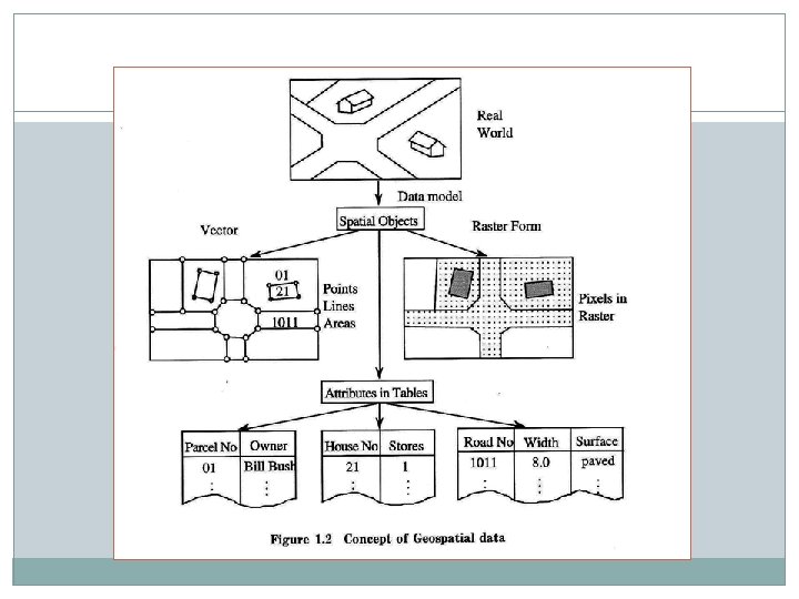
Classification of Geospatial Data �Graphical data (called geometric data) �Attributes (called thematic data)

Components of GIS �Key components of GIS are: Computer system, geospatial data, and users Computer System �Sources of geospatial data are: Digitized maps, aerial photographs, satellite images, statistical tables, and other related documents Geospatial Data Users Figure: Key components of GIS
 �Attributes (called thematic data) Real")
Classification of Geospatial Data �Graphical data (called geometric data) �Attributes (called thematic data) Real World Data Model Spatial Objects Points Lines Areas Raster Form Vector Attributes in Tables Figure: Concept of Geospatial Data Pixels in Raster

Why GIS is needed ? Common problems of handing geospatial information: ØGeospatial data are poorly maintained. ØMaps and statistics are out of date. ØData and information are inaccurate. ØThere is no data retrieval service. ØThere is no data sharing.

Benefits once GIS is implemented Ø Geospatial data are better maintained in a standard format. Ø Revision and updating are easier. Ø Geospatial data and information are easier to search, analysis and represent. Ø More value added product. Ø Geospatial data can be shared and exchanged freely. Ø Productivity of the staff improved and more efficient. Ø Time and money are saved. Ø Better decision can be made.
 Memory (RAM) >")
Computer System for GIS � Hardware System Central Processing Unit (CPU) Memory (RAM) > 64 MB I/O Device � Plotters, printers, mouse, digitizers, scanners, digital camera � Software System Operating System � Compiler � DOS, Windows C++, Pascal, Fortran, BASIC Application Programs � Arc. GIS, MGE, Geo/SQL, GFIS, IDRISI*, GRASS* * public domain software

Area of GIS Applications Area GIS Applications Facilities Management Locating underground pipes & cables, planning facility maintenance, telecommunication network services Environmental and Natural Resources Management Environmental impact analysis, disaster management and mitigation Street Network Locating houses and streets, car navigation, transportation planning Planning and Engineering Urban planning, regional planning, development of public facilities Land Information Taxation, zoning of land use, land acquisition

What is remote sensing � Remote Sensing: remote sensing is science of acquiring, processing, and interpreting images and related data that are obtained from ground-based, air-or spaceborne instruments that record the interaction between matter (target) and electromagnetic radiation. � Remote Sensing: using electromagnetic spectrum to image the land, ocean, and atmosphere. � In this class, we will mostly focus on the principles and techniques for data collection and the interaction of electromagnetic energy with the Earth's surface some application examples also you will get familiar with ENVI, an image processing software.

What we measure in remote sensing? 123 4 5 7

Solar radiation

Applications of National Priority Carbon Management Public Health Energy Management Aviation Water Management Homeland Security Coastal Management Disaster Management Agricultural Efficiency Invasive Species Ecological Forecasting Air Quality

Research Systems to Operational Systems Imaging and Sounding Sea. Wi. FS Aqua NPP NPOESS Solar Irradiance, Ozone, and Aerosols Observation In operation Under Development In Formulation Tech Development Terra ACRIMsat SORCE SAGE III AURA Glory NPOESS NPP Atmospheric Composition UARS AURA NPOESS TBD Ocean Surface Topography Jason NOAA/EUMETSAT Land Cover/Land Use Change Tech Landsat 7 Data Assim * Canceled flight mission; gleaning technology for GOES-R OSTM LDCM Operational NPOESS GIFTS* GOES Tropo Winds TBD Joint Center for Satellite Data Assimilation NCEP Short-term Prediction Research and Transition Center NWS NASA & NOAA jointly funding NRC studies on improving transition

Trend and Future of Remote Sensing � Globe coverage, high repeatability (or improved temporal resolution) - AVHRR, 1100 m, morning or afternoon - MODIS, 250 -1000 m, morning or afternoon - NPOESS (will be launched in 2013), 370 -740 m, 4 hours � Real-time or near real-time availability - MODIS available online in the second day ? - NEXRAD available online in 6 minutes - NPOESS available online in 15 minutes � Cost free or affordable - Most of the federal collected images are free available or lower cost, while commercial high resolution images are affordable. � Integrated remote sensing and GIS - Remote sensing applications with the support of GIS - Remote sensing data as a major GIS data source

Hydrology: Current Research Related Conferences 2 nd Petroliferous Basins Oct 3 -5, 2016 London, UK

Hydrology: Current Research Related Journals Ø Journal of Geology & Geosciences Ø Journal of Geophysics & remote Sensing

OMICS Group Open Access Membership OMICS International Open Access Membership enables academic and research institutions, funders and corporations to actively encourage open access in scholarly communication and the dissemination of research published by their authors. For more details and benefits, click on the link below: http: //omicsonline. org/membership. php
- Slides: 21