KILROOT SALT MINE GEOLOGY LOCATION Kilroot Salt Mine


: largest application")
- Slides: 7
KILROOT SALT MINE GEOLOGY
LOCATION Kilroot Salt Mine
IRISH SEA BASINS – MMG HALITES Larne Basin East Irish Sea Basin Cheshire Basin
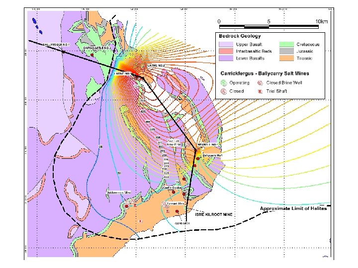
KILROOT to BALLYTOBER TOP MMG SCHEMATIC SECTION Vertical Exaggeration x 2 Ballytober No. 1 Larne No. 2 1000 m 2 km Newmill No. 1 LARNE BASIN Sixmilewater Fault GSNI GT 01
SUMMARY GEOLOGICAL SEQUENCE INTERSECTED IN THE KILROOT – BALLYCARRY AREA Ma PERIOD / GROUP 61 TERTIARY AGE Formation Palaeocene Lower Basalt Formation Clay with Flints K/T INTERVAL Member Typical Thickness (mtrs. ) 103. 7+ 2. 8 UNCONFORMITY 70 Maastrictian Santonian Ulster White Limestone Formation 97. 5 Santonian Cenomanian Hibernian Greensands Formation 207 Pliensbachian Hettangian CRETACEOUS Collinwell Sands 11. 2 2. 3 9. 2 4. 8 Planorbis + Pre. Planorbis 0. 0 Langport 6. 3 Cotham 2. 5 Cloghfin Sponge Bed Kilcoan Sands UNCONFORMITY JURASSIC Waterloo Mudstone Formation UNCONFORMITY 209 TRIASSIC PENARTH GRP. Rhaetian Lilstock Formation Westbury Formation 8. 9 UNCONFORMITY Collin Glen Formation Norian TRIASSIC MERCIA MUDSTONE GROUP Carnian Ladinian Port More Formation Knocksoghey Formation Anisian 245 (Keuper Marl) 5. 6 (Tea Green Marls) Glenstaghey Formation 64. 7 Upper Knocksoghey 39. 9 Coolmaghera Skerry 5. 2 Lower Knocksoghey 54. 1 Upper Glenstaghey 24. 4 LARNE HALITE 62. 0
Underground Mine Extension • 280 hectares underground mine extension (340 football pitches): largest application in N. Ireland • Mining depth 300 to 500 metres below surface • Salt reserves c. 15 million tonnes (30 years)