Karst Topography Features and Landforms 28102014 KARST TOPOGRAPHY


 Origins Solution Subsidence Collapse")


- Slides: 26
Karst Topography Features and Landforms 28/10/2014
KARST TOPOGRAPHY Word is German form of the Yugoslavian term “Kras” means “bare stony ground” Named after investigating a region near the Adriatic Sea in Yugoslavia In modern Geomorphology the term refers to any landscape formed by dissolution of the underlying bedrock Characterized by distinctive landforms which don’t typically occur in any other circumstance Pseudokarst is the term for karst-like development in non-carbonate lithology that exhibits characteristics similar to karst landscapes, but which lack dissolution as a primary means of landscape formation. Some common features include v Irregular terrain v Dolines: Sinkholes or sinks (formed by groundwater slowly dissolving the bedrock often accompanied by collapse v Disappearing (aka sinking) streams
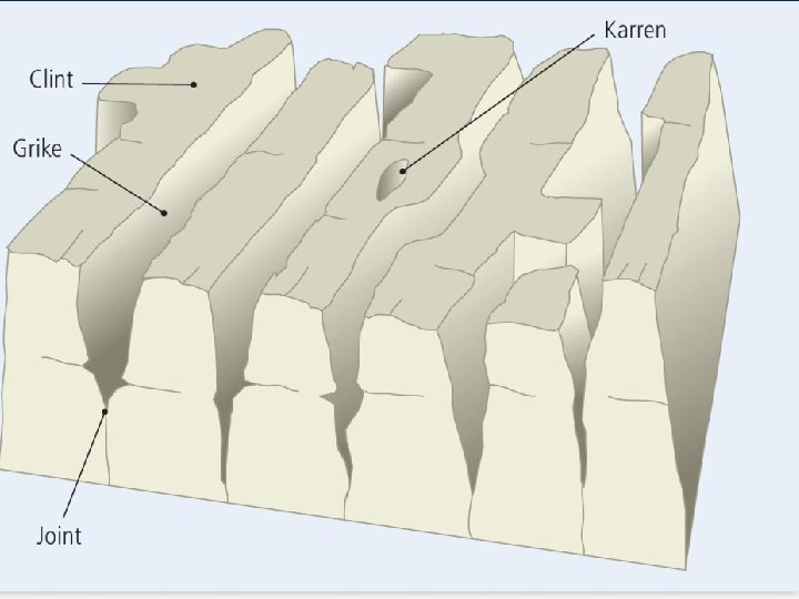
LIMESTONE PAVEMENTS Flat areas of exposed limestone Resemble artificial pavements Comprise large rectangular blocks called clints separated by long grooves known as grykes A result of chemical weathering along the joints and cracks in the limestone rocks The grykes will deepen and widen over time Karren: small hollow that forms on the surface of a limestone clint A limestone pavement in Malham Cove, England
Gryke Clint
Depressions Doline (sinkhole, cenote) Origins Solution Subsidence Collapse
DEPRESSIONS Sinkhole / Doline - comes in a variety of shapes most often funnel shaped forms as material above a cavity becomes too thin to support the weight sometimes filled with colluvium from edges of feature can form circular lakes often entrances to caves are found in sinkholes related to formation of feature Uvalas a. k. a Compound sinks - several sinkholes coalesce to form a larger structure these may be quite large (a kilometer) Polje – sometimes referred to as a karst valley. It is broad and flat – floored often associated with faulting.
Sinkholes
Sinkholes Groundwater dissolves soluble rock, creating fractures and caves. Dissolving continues to form larger caves and fractures.
Dolines Collapse sinkholes form when water level drops Solution sinkholes due dissolution at surface
Polje A polje is a large flat plain in karst territory, often structurally controlled Copyright © Jelena Calic-Ljubojevic 2002
RESIDUAL CONES AND TOWERS Tower Karst
COCKPIT KARST is a form of karst in which the residual hills are chiefly hemispheroidal and surround closed, lobed, depressions known as dolines or "cockpits" each of which is drained to the aquifer by one or more sinkholes. Arecibo Radio Astronomy Observatory, Puerto Rico
TOWER KARST are steep or vertical sided limestone towers each 30 -300 m high. Towers originate as residual cones and are then steepened by water table undercutting from surround alluviated plains. By far the most extensive and best developed tower karst is the Guangxi province of southern China
DRY VALLEYS Steep-sided valleys that no longer have water flowing over the surface During the last ice age, limestone was frozen to great depths As the climate warmed, melting ice formed rivers that carved out valleys over the still-frozen rocks When the rocks thawed, the water infiltrated down through the rocks and the valleys were left with no surface water, resulting in dry valleys Underground caves may form below dry valleys The caves may collapse to form a gorge
The dry valley above Malham Cove, Yorkshire Dales, North Yorkshire, England
CAVES AND CAVERNS
Cave Deposits - Speleothems CAVES are natural underground cavities. They form very slowly. Begin to form first just below the surface of the water table in the zone of saturation. Become dry when water table goes below the cave horizon. Cave systems are formed when dissolution produces a series of caves. Related to fluctuating groundwater table. Ca. CO 3 (s) + 2 H+ (aq) Ca++ (aq) + CO 2 (g) + H 2 O(l) Groundwater seepage causes stalagmites, stalactites.
Caves § Swallow holes – river disappears underground § Carbonation – passages form large caverns § River erodes the rock of the cave by abrasion and hydraulic action § Carbonation and solution dissolve permeable rock (limestone) § Cave develops at or below zone of saturation
Dripstone Features § § § § § Stalactites Drops of water containing dissolved limestone seep down through cracks/fissures in the cave roof Drops of water lose carbon dioxide and deposit calcite Over time deposition of calcite forms the stalactites hanging down from the roof of the cave Stalactites are hollow mineral tubes, like drinking straws They are very thin and fragile Stalagmites Water droplets fall to the cave floor Drops of water lose carbon dioxide and deposit calcite Over time deposition of calcite form the stalagmites growing upward from the cave floor form directly below stalactites Stalagmites are thicker than the stalactites
Pillars § Stalactites and stalagmites grow towards each other § Eventually join to form a pillar or column Curtains § Rainwater drips from a long crack in a cave roof forms a continuous strip of calcite
Quick Revision Questions Name the main weathering process effective on limestone List the three parts of a limestone pavement Name another surface landform found in a limestone region Name four underground landforms in a limestone region Describe a stalactite Due : Tuesday 28 th October, 2014
Case study: The Jamaican karst landscape – Cockpit Country Mostly located in Trelawny, but spreads through the neighbouring parishes of St Elizabeth and St James Characterised by a regular series of round-topped conical hills and pits The landscape of Cockpit Country
Formation Cockpit Country is a massive limestone plateau with an elevation of about 600 m above sea level According to one theory, its characteristic topography is the result of heavy tropical rain washing through the fissured plateau over millions of years The water dissolved and eroded the fissures and washed the debris through the sinkholes into the sea Another theory postulates that water moves slowly at the top of the hills with little erosion As the water flowed downhill, it picked up momentum and gathered debris, resulting in a more pronounced scouring action
Features of a karst landscape
Identifying karst features on a topographical map Undulating landscape as indicated by the irregular contour pattern Dry valleys Depressions – as indicated by short hash marks inside circles Disappearing streams Springs at the foot of steep escarpments and place names that begin with ‘spring’ such as ‘Springvale’. Deep gorges Features and symbols that represent quarries and cement-making, since limestone is an important ingredient for cement production Little or no surface drainage