KALWAN EDUCATION SOCIETYS ARTS COMMERCE AND SCIENCE COLLEGE
 DEPARTMENT OF GEOGRAPHY TOPIC:")


 Half Nehrung Coasts: It is regular and low coastline, It is found where")
 Dalmatian coast: Dalmatian coasts are characterised by parallel inlets and long narrow hilly")
 Fiord Coastline: Fiord coast are very typical kind of coasts those run perpendicular")
 Ria coast: Ria coasts are irregular and indented. They are formed generally due")

 Submergence: Submergence implies the rise in sea level or depression of land")
 Submerged mountain range: Submerged mountain ranges dispose parallel with the coast giving appearance")
 Neutral Shorelines: These are found in areas where there are no sea")

- Slides: 21
KALWAN EDUCATION SOCIETY’S ART’S COMMERCE AND SCIENCE COLLEGE, KALWAN (MANUR) DEPARTMENT OF GEOGRAPHY TOPIC: COASTS ( F. Y. B. SC ) BY, ASST. PROF. WAGHERE P. P.
COASTS
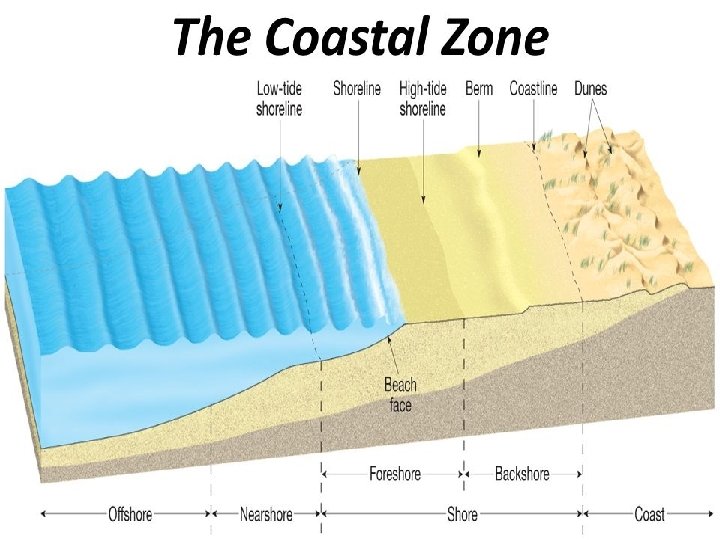
Generally coast and coastline, shore and shoreline are often used repeatedly in oceanographic studies. However, these terms bear clear distinctions geographically. Coast: The coasts is the irregular marginal land facing the sea or ocean body. It fronts the seaside. It is much larger in extent than shore or shoreline. It is the part of the land that borders the sea or other extensive zone of water body. It come under the influence of sea waves. Coastline: The coastline is delineated by the cliff line or it is the line reached by stormy waves.
Shore: The shore is a narrow zone of variable width between low water mark and the base of the cliff or equivalent relief. Shoreline: The shoreline is the extent of sea waves in force. It includes bays, river mouths with tides water limit and narrow inlets of sea. Thus shoreline is the landmark between land water, it is the interface where land water meet. It is at this line that sea border is brought against the land surface. The front portion towards sea is known as foreshore while the region immediately below the base of the cliff or equivalent is known as backshore. The region that extends towards the sea from the low water line is known as the offshore zone.
Foreshore: The part of a shore between high water and low water, especially the beach exposed at maximum ebb spring tides. Backshore: The backshore area of a beach extends from the limit of high water foam lines to dunes or extreme inland limit of the beach. It is only affected by waves during exceptional high tides or severe storms. Offshore: The offshore zone is not clearly delimited. In relation to beach terminology, the offshore zone is often defined as the zone off the nearshore zone. Nearshore: The zone extending seaward from the low water line well beyond the breaker zone; it defines the area influenced by the nearshore currents. The nearshore zone extends somewhat further seaward than the littoral zone.
The study of coast or coastlines is of prominent importance in the field of oceanography and geography. Shoreline represented margin of the sea and coastline represented margin of the land. Coast as boundaries of the land against the sea or ocean, depend upon the general structural character of the land area. Therefore, character of land like configuration, types of rocks, structure planes, sloping direction , straitness or irregularities high, or low in relation of vertical extent, geological evolution, tectonic history play important role in the coastal characters.
Types of Coasts In 1892. Austrian geologist Suess made distinction between coast of Pacific type and Atlantic type in relation to longitudinal coastline and transverse coastline respectively. Pacific coasts run parallel to the structural trends of the young folded mountain ranges and were generally disposed longitudinally, hence known as longitudinal coast. On the contrary, Atlantic types of coast were independent and generally followed across the structural grain of the margin of continents.
Coastline Longitudinal Coastline Or Concordant coast Or Pacific Type Nehrung Coast Dalmatian Coast Transverse Coastline Or Discordant coast Or Atlantic Type Fiord Coast Ria Coast
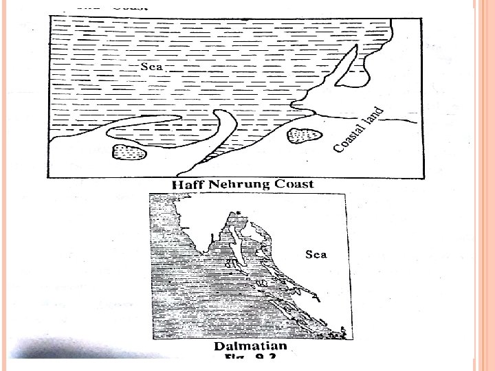
1) Half Nehrung Coasts: It is regular and low coastline, It is found where the land before submergence was of soft kind sedimentary rock. A typical half coastline consists of large sandy strips running parallel to the coast and enclose shallow lagoons known as “Haffs”. Haffs coast is not ideal for harbour facility and part development. The lagoons may recede in due coarse of time and produce an enclosed water area. Haff coasts is typically found in eastern part of Germany.
2) Dalmatian coast: Dalmatian coasts are characterised by parallel inlets and long narrow hilly islands. Such coasts are formed due to submergence of coast and mountain chains running from northwest to the southeast direction. Therefore, the inlets are the longitudinal structures, valleys or hollows submerged at present but the rocky islands are even submerged tops of the mountains. Dalmatian type of coasts are found in Eastern Adriatic sea, the west coast of Yugoslavia and Mumbai coast of India.
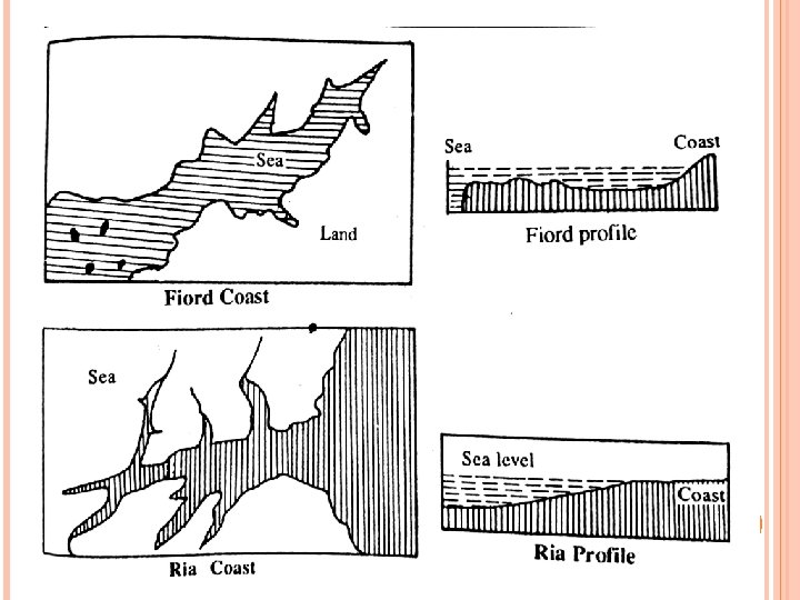
3) Fiord Coastline: Fiord coast are very typical kind of coasts those run perpendicular to the structure. In Scotland, Labrador and Newfoundland drowning of Glacial valleys consists of steep sloping and a broad U shape. The general plan of the fiord and its branches is essentially rectangular as shown in the diagram. The floor of the fiord is little deeper than the sea floor. It is roughly a rock basin. It is further pointed out that fiord are shallower towards the sea face, it is the result of melting of snow and gradual sinking of land. Such coasts produce ideal conditions for development of port.
4) Ria coast: Ria coasts are irregular and indented. They are formed generally due to drowning of river valleys, hence the sides of inlets are gently sloping. Accessibility of this coast is much simpler and easier. Ria coast are extensively exposed to wave attack. Due to open attack to wave action the Ria coasts are eroded and they exhibit erosional or destruction forms. Rias are well found in south west Ireland, north western Spain and Cornwall area of Great Britain. These are intensively slow degradational relief features on large scale.
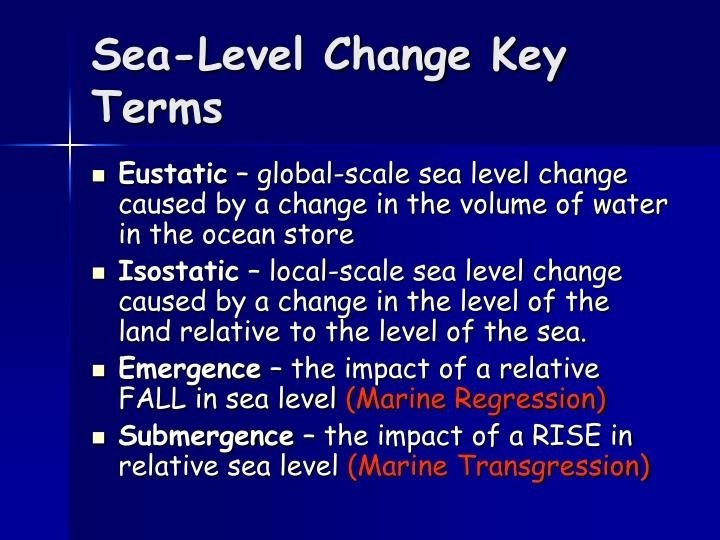
Submergence and Emergence of Coasts: Scholars attempted to classify the coastline according to their position with respect to sea level. commonly adopted classification scheme was put forward by D. M. Johnson in 1918. According to Johnson there are four main types given below: 1) Submergence 2) Emergence 3) Neutral 4) Compound
1) Submergence: Submergence implies the rise in sea level or depression of land along the coast due to some diastrophic or tectonic movements of the earth. There are subtypes of submergence according to relief observation. I) Submerged lowland regions: Submerged lowland regions produce estuarine coasts with shallow and broad indentations with mudflats at low tides. Such coasts possess many creek. Example: Coast of North Germany and East England. II) Submerged lowland regions: Submerged lowland coasts are Ria type and fiord, funnel shaped, branching inlets. Example: Galicia in NW Spain, SW Ireland coasts, Norwegian coast of fiord character.
III) Submerged mountain range: Submerged mountain ranges dispose parallel with the coast giving appearance and characteristic feature of Dalmatian coast. There are, elongated offshore island. Example: Bothanian coast of finland Sweden, coastline of south eastern U. S. A. 2) Emerged coast: There is emerged upland shore due to uplift of highland along the coast with raised beaches or cliffs. Example: coast of eastern Scotland in North Great Britain.
3) Neutral Shorelines: These are found in areas where there are no sea level changes or land margins. In other words when there is no sign of submergence or emergence so far. Example of this type are: 1. Coral forming 2. Alluvial and delta shoreline 3. Volcanic shoreline 4) Compound Shoreline: Compound Shorelines exhibit signs of both submergence and emergence or which combine two or more subtypes mentioned in the earlier explanation.