June November 2018 Atlantic Hurricane Season Outlooks NearNormal

June – November 2018 Atlantic Hurricane Season Outlooks Near-Normal activity compiled by CIMH Kathy-Ann Caesar, Chief Meteorologist, CIMH Dr. Cédric Van Meerbeeck, Climatologist, CIMH
 CSU")
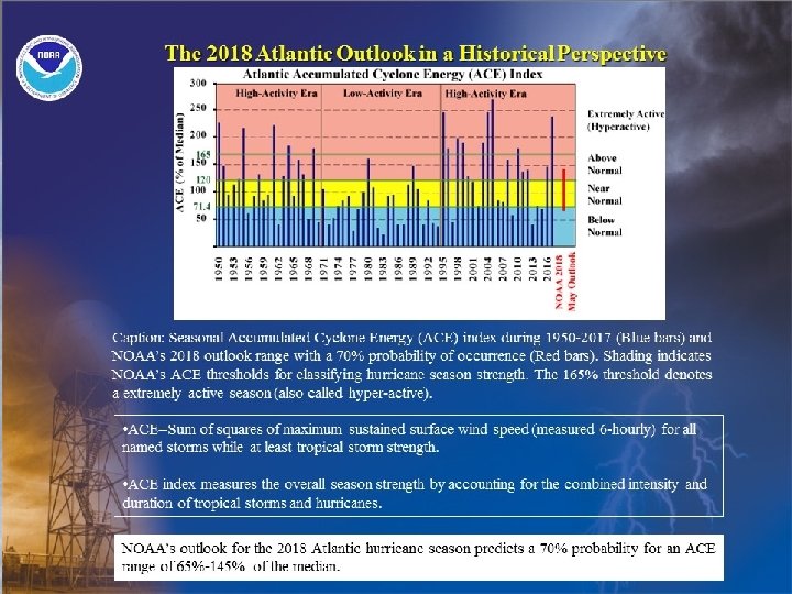
2018 Hurricane Season Forecasts 2 Forecast Parameter and 1981 -2010 Climatology (in parentheses) CSU May 31 st 2018 Tropical Storm Risk May 30 th 2018 Weather Channel May 2018 NOAA Climate Prediction Center 24 May 2018 Named Storms (NS) (12) 14 9 12 10 -16 Hurricanes (H) (5. 9) 6 4 5 5 -9 Intense Hurricanes (IH) (2. 3) 2 1 -4 Accumulated Cyclone Energy (ACE) (Median = 100) 88 43 65 -145%
 1. 2. January - March values")
Predictors Slightly Above average season predicted; Predictors (CSU) 1. 2. January - March values of 1. sea surface temperature (SST), 2. sea level pressure (SLP), 3. 200 mb zonal wind, and 4. 850 mb zonal wind, respectively. In general, higher values of SSTs, lower values of SLP, anomalous westerlies at 850 mb and anomalous easterlies at 200 mb are associated with active Atlantic basin hurricane seasons.
 (+) 2 -")
CSU Predictor Impact Predictor 11 - April-May SST (15 -55°N, 1535°W) (+) 2 - April-May 200 MB U (0 -15°S, 150°E-120°W) (+) 3) ECMWF 1 May SST Forecast for September Nino 3 (5°S-5°N, 90 - 150°W) (-) +0. 6 SD 4) May SLP (20 -40°N, 30 -50°W) (-) +2. 4 SD Impact on 2018 TC 2018 Forecast Value Activity -0. 9 SD Decrease +1. 3 SD Increase +0. 6 SD Decrease +2. 4 SD Decrease Listing of 1 June 2018 predictors for the 2018 hurricane season. A plus (+) means that positive values of the parameter indicate increased hurricane activity. The combination of the four predictors calls for a below-average Atlantic hurricane season. SD stands for standard deviations.

Models suggest a trend toward an El Niño a peak season ENSO forecasts from various statistical and dynamical models for the Nino 3. 4 SST anomaly based on late February to early March initial conditions. 40% of all forecast models are calling for El Niño conditions by August. October (black arrow), which is the climatological peak of the Atlantic hurricane season. Figure courtesy of the International Research Institute (IRI). EL NIÑO LA NIÑA
 May SST Anomaly")
El Niño/SO – Neutral to Weak Region March SST Anomaly (°C) May SST Anomaly (°C) Late May minus late March SST anomaly changes across the tropical Pacific. There remains uncertainty as to the status of the El Nino in the midst of the upcoming season, however, May SST anomalies generally reflect ENSO neutral conditions May March Nino 1+2 Nino 3. 4 Nino 4 -0. 8 -0. 7 -0. 1 -0. 6 -0. 2 -0. 1 0. 2 0. 6 0. 3 March and May SST anomalies for Nino 1+2, Nino 3. 4, and Nino 4, respectively. March-January SST anomaly differences show slight warming trend

The tropical North Atlantic Ocean currently cool Credit: Dr. Philip Klotzbach, CSU

May 2018 SST anomaly pattern across the Atlantic Ocean not conducive to TS activity Late May 2018 SST anomaly pattern across the Atlantic Ocean shows cold anomalies Anomalous SST change from late March to late May 2018. Anomalous cooling occurred over most of the eastern tropical Atlantic.

Abnormally strong Subtropical High The reason for the cooler SST is a strong sub-tropical high This drives cooler northerly winds into the tropical Atlantic And warm SST into the Eastern Caribbean

Tropical Storm Risk Hurricane Forecast The TSR forecast for 2018 hurricane activity is below the long term norm 1. These are the anticipated suppressing effects of the July-September forecast trade wind at 925 mb height over the Caribbean Sea and tropical North Atlantic region 2. The current forecast for the July-September trade wind is 1. 65± 0. 70 ms-1 stronger than normal (1980 -2017 climatology) The August-September forecast SST for the North Atlantic MDR (10°N– 20°N, 20°W– 60°W). The current forecast for the August-September MDR SST is 0. 54± 0. 22°C cooler than normal which is notably colder than the April forecast value of 0. 16± 0. 26°C cooler than normal (1980 -2017 climatology).

Caribbean Landfall probabilities CSU Caribbean Forecast 2018 A below probability for major hurricanes making landfall in the Caribbean PROBABILITY FOR AT LEAST ONE MAJOR (CATEGORY 3 -4 -5) HURRICANE TRACKING INTO THE CARIBBEAN (10 -20°N, 60 -88°W) 41% (average for last century is 42%) TSR - Caribbean Forecast Caribbean Sea and Gulf of Mexico 2018 Possible 4 Named Storm, 3 Hurricanes and 1 Intense Hurricane Lesser Antilles Land falling Numbers in 2018 Possible 1 Named Storm and no Hurricanes

Declaimer DISCLAIMER CIMH is providing special weather interpretation of the current and forecasted tropical weather affecting the Caribbean region. CIMH is not an official forecasting agency.
- Slides: 14