JPSS Cloud Products Quick Guides Cloud Top Altitude
- Slides: 8

JPSS Cloud Products Quick Guides

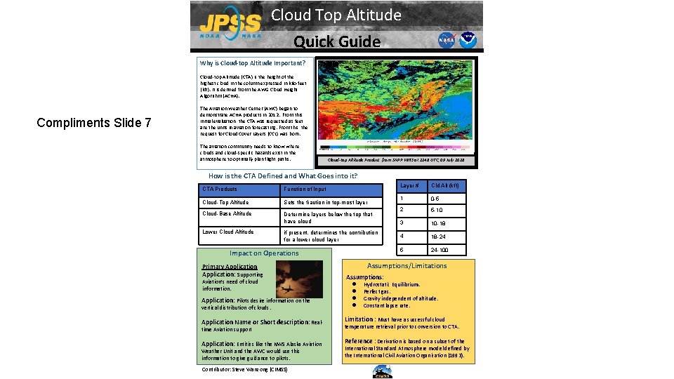
Cloud Top Altitude Quick Guide Why is Cloud-top Altitude Important? Cloud-top Altitude (CTA) is the height of the highest cloud in the column expressed in kilo-feet (kft). It is derived from the AWG Cloud Height Algorithm (ACHA). Compliments Slide 7 The Aviation Weather Center (AWC) began to demonstrate ACHA products in 2012. From this initial evaluation, the CTA was requested as feet are the units in aviation forecasting. From this, the request for Cloud Cover Layers (CCL) was born. The aviation community needs to know where clouds and cloud-specific hazards exist in the atmosphere to optimally plan flight paths. Strong updrafts Cloud-top Altitude Product from SNPP VIIRS at 2248 UTC, 09 July 2018 How is the CTA Defined and What Goes into it? CTA Products Function of Input Cloud-Top Altitude Sets the fraction in top-most layer Cloud-Base Altitude Determine layers below the top that have cloud Lower Cloud Altitude if present, determines the contribution for a lower cloud layer Impact on Operations Primary Application: Supporting Aviation’s need of cloud information. Application: Pilots desire information on the vertical distribution of clouds. Layer # Cld Alt (kft) 1 0 -5 2 5 -10 3 10 -18 4 18 -24 5 24 -100 Assumptions/Limitations Assumptions: ● ● Hydrostatic Equilibrium. Perfect gas. Gravity independent of altitude. Constant lapse rate. Application Name or Short description: Real- Limitation : Must have a successful cloud Application: Entities like the NWS Alaska Aviation Reference : Derivation is based on a subset of the time Aviation support Weather Unit and the AWC would use this information to give guidance to pilots. Contributor: Steve Wanzong (CIMSS) temperature retrieval prior to conversion to CTA. International Standard Atmosphere model defined by the International Civil Aviation Organization (1993).

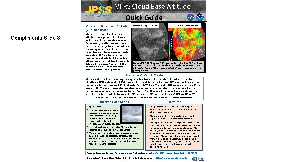
VIIRS Cloud Base Altitude Quick Guide Why is the Cloud Base Altitude (CBA) Important? Compliments Slide 8 The CBA is an estimation of the base altitude of the uppermost cloud layer in each column of the atmosphere as viewed from above by satellite. Information of 3 -D cloud structure is significant to the aviation community. It also bears high relevance to model developers for weather and climate applications. CBA is a key component required to construct a full 3 -D cloud field, although assigning cloud base from satellite data is still challenging. The current CBA algorithm is operational as part of the NOAA Enterprise Cloud Algorithms. VIIRS Cloud Base Height Infrared (IR) 10. 76µm Sample VIIRS IR (10. 76 µm) and VIIRS Cloud Base Height [km] from S-NPP VIIRS over Alaska at 2203 UTC, 28 July 2018. For ‘Alaska Cloud Product Demo’ users: product will be distributed in AWIPS (displayed in kilofeet, kft) and the Web via Polar 2 Grid (starting Fall 2018). How is the VIIRS CBH Created? The CBA is obtained from a semi-empirical approach, based on a statistical analysis of multiple satellite data (Cloud. Sat/CALIPSO and Aqua MODIS). In the algorithm, Cloud Geometric Thickness (CGT) is derived from statistical relationships between observed CGT, Cloud Water Path (CWP), Cloud Top Height (CTH) and subtracted from CTH to generate CBH. The algorithm includes special accommodations for handling optically thin cirrus (an extinction method) and deep convection (supplementary NWP data). The CBA product is provided for any cloudy pixel with valid cloud top height globally, day and night (750 m resolution, ~50 min revisit between S-NPP and NOAA-20). CBH = CTH – CGT and CGT = (a * CWP) + b, where a and b are obtained from statistical relationships. Impact on Operations Applications: • • • CBH information can be used to improve the Cloud Cover Layers (CCL) products by introducing additional cloud coverage at lower levels of the profile, typically hidden under cloud top. Vertical cloud structures including CBH provide useful information for aviation weather applications. The CBH algorithm is also applicable to geostationary sensors as well as polar satellite sensors. Global observations of 3 -D cloud fields are relevant to model developers for integrating improved cloud radiative feedbacks in numerical models. Limitations • The performance of the CBH retrieval is highly dependent on the accuracy of CTH and CWP (from cloud optical properties). • The nighttime CBH retrieval performance would be degraded due to the difficulty of CWP retrievals. • The algorithm is optimal for single layer clouds or the uppermost layer of multi-layered clouds. The CBH may not be ‘ceiling’ for multi-layered cloudy scenes. The accuracy of the CBH product for multi-layer clouds may comprise the uncertainties of the upstream retrievals. Most likely CBH = actual ceiling in cases of an optically thin cirrus cloud that is not categorized as a “multilayer” cloud type, a boundary layer cloud, and a cloud base for deep convection derived using NWP supplementary data. Resource: Development of a statistical cloud base height retrieval algorithm: Noh et al. , 2017, J. Atmos. Ocean. Tech. , 34(3), 585 -598. Contributor: Y. J. Noh, Steve Miller (CIRA/Colorado State University) https: //www. cira. colostate. edu

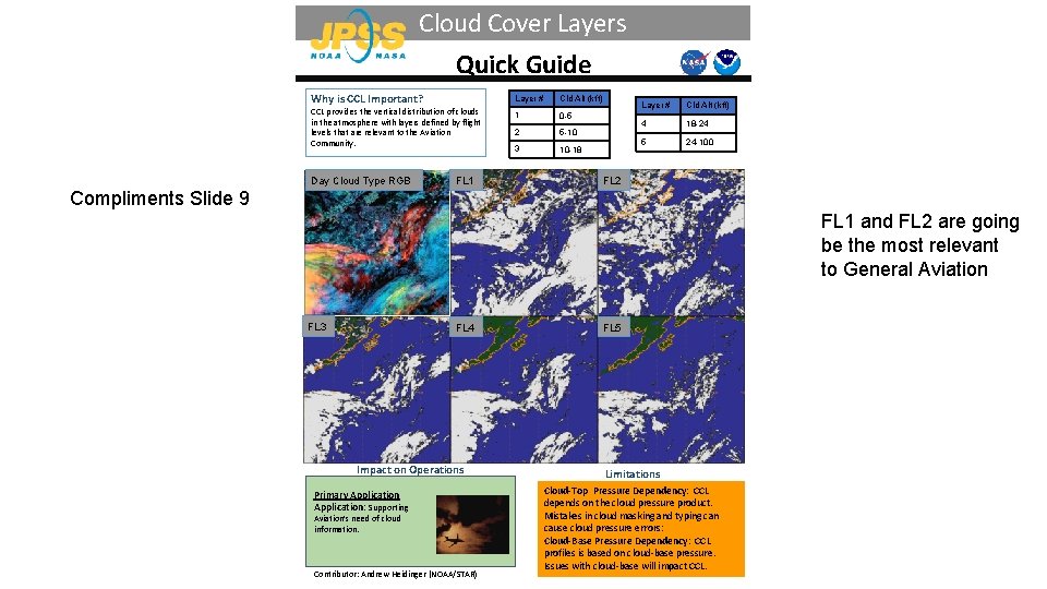
Cloud Cover Layers Quick Guide Why is CCL Important? CCL provides the vertical distribution of clouds in the atmosphere with layers defined by flight levels that are relevant to the Aviation Community. Day Cloud Type RGB FL 1 Layer # Cld Alt (kft) 1 0 -5 2 5 -10 3 10 -18 Layer # Cld Alt (kft) 4 18 -24 5 24 -100 FL 2 Compliments Slide 9 FL 1 and FL 2 are going be the most relevant to General Aviation FL 3 FL 4 Impact on Operations Primary Application: Supporting Aviation’s need of cloud information. Contributor: Andrew Heidinger (NOAA/STAR) FL 5 Limitations Cloud-Top Pressure Dependency: CCL depends on the cloud pressure product. Mistakes in cloud masking and typing can cause cloud pressure errors: Cloud-Base Pressure Dependency: CCL profiles is based on cloud-base pressure. Issues with cloud-base will impact CCL.

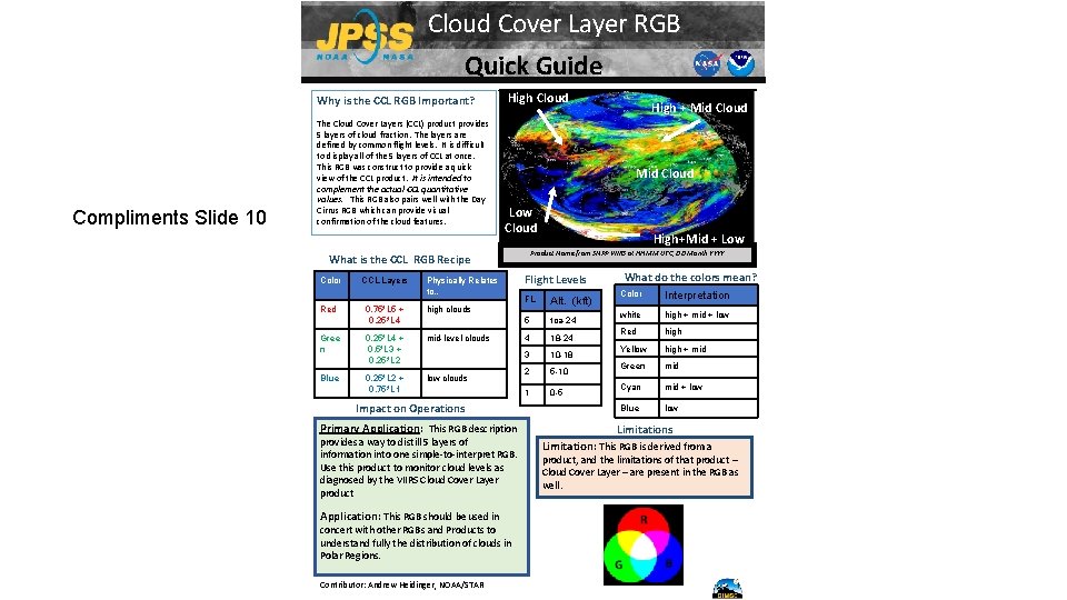
Cloud Cover Layer RGB Quick Guide Why is the CCL RGB Important? Compliments Slide 10 The Cloud Cover Layers (CCL) product provides 5 layers of cloud fraction. The layers are defined by common flight levels. It is difficult to display all of the 5 layers of CCL at once. This RGB was construct to provide a quick view of the CCL product. It is intended to complement the actual CCL quantitative values. This RGB also pairs well with the Day Cirrus RGB which can provide visual confirmation of the cloud features. High Cloud Mid Cloud Low Cloud Red CCL Layers Physically Relates to… 0. 75*L 5 + 0. 25*L 4 high clouds Gree n 0. 25*L 4 + 0. 5*L 3 + 0. 25*L 2 mid-level clouds Blue 0. 25*L 2 + 0. 75*L 1 low clouds Impact on Operations Primary Application: This RGB description provides a way to distill 5 layers of information into one simple-to-interpret RGB. Use this product to monitor cloud levels as diagnosed by the VIIRS Cloud Cover Layer product Application: This RGB should be used in concert with other RGBs and Products to understand fully the distribution of clouds in Polar Regions. Contributor: Andrew Heidinger, NOAA/STAR High+Mid + Low Product Name from SNPP VIIRS at HHMM UTC, DD Month YYYY What is the CCL RGB Recipe Color High + Mid Cloud Flight Levels FL Alt. (kft) 5 toa-24 4 18 -24 3 10 -18 2 5 -10 1 0 -5 What do the colors mean? Color Interpretation white high + mid + low Red high Yellow high + mid Green mid Cyan mid + low Blue low Limitations Limitation: This RGB is derived from a product, and the limitations of that product – Cloud Cover Layer – are present in the RGB as well.

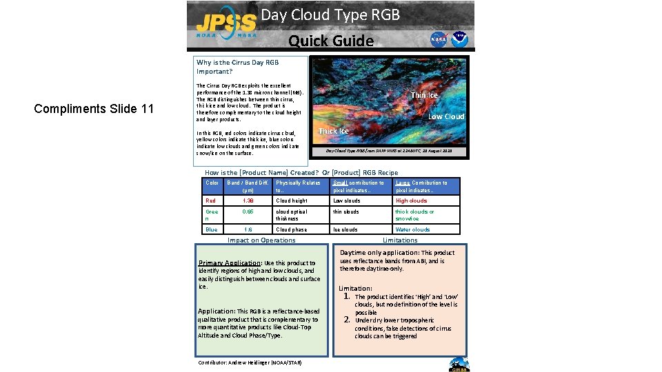
Day Cloud Type RGB Quick Guide Why is the Cirrus Day RGB Important? Compliments Slide 11 The Cirrus Day RGB exploits the excellent performance of the 1. 38 micron channel (M 9). The RGB distinguishes between thin cirrus, thick ice and low cloud. The product is therefore complementary to the cloud height and layer products. In this RGB, red colors indicate cirrus cloud, yellow colors indicate thick ice, blue colors indicate low clouds and green colors indicate snow/ice on the surface. Thin Ice Low Cloud Thick Ice Day Cloud Type RGB from SNPP VIIRS at 2248 UTC, 28 August 2018 How is the [Product Name] Created? Or [Product] RGB Recipe Color Band / Band Diff. (µm) Physically Relates to… Small contribution to pixel indicates… Large Contribution to pixel indicates… Red 1. 38 Cloud height Low clouds High clouds Gree n 0. 65 cloud optical thickness thin clouds thick clouds or snow/ice Blue 1. 6 Cloud phase Ice clouds Water clouds Impact on Operations Limitations Daytime only application: This product Primary Application: Use this product to identify regions of high and low clouds, and easily distinguish between clouds and surface ice. Application: This RGB is a reflectance-based qualitative product that is complementary to more quantitative products like Cloud-Top Altitude and Cloud Phase/Type. Contributor: Andrew Heidinger (NOAA/STAR) uses reflectance bands from ABI, and is therefore daytime-only. Limitation: 1. 2. The product identifies ‘High’ and ‘Low’ clouds, but no definition of the level is possible Under dry lower tropospheric conditions, false detections of cirrus clouds can be triggered

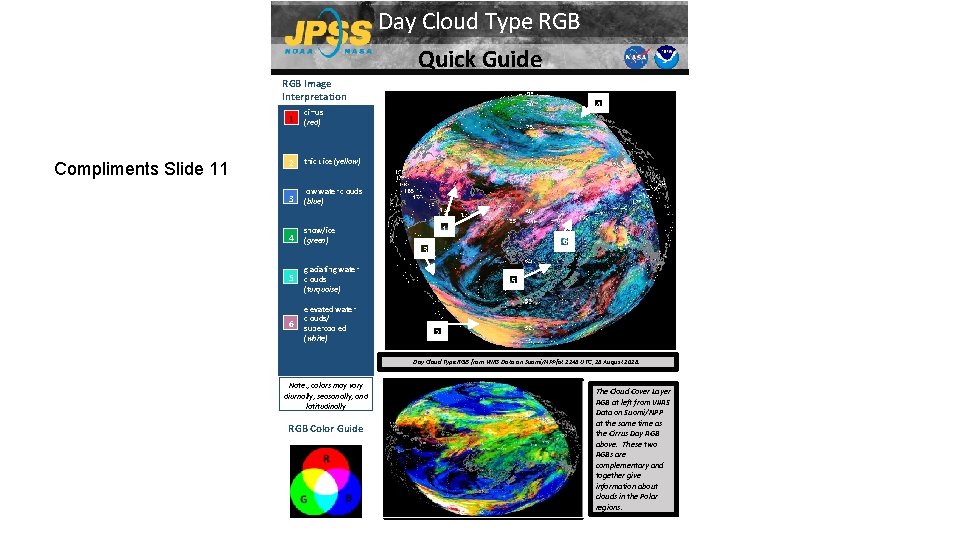
Day Cloud Type RGB Quick Guide RGB Image Interpretation Compliments Slide 11 1 cirrus (red) 2 thick ice (yellow) 3 low water clouds (blue) 4 snow/ice (green) 5 glaciating water clouds (turquoise) 6 elevated water clouds/ supercooled (white) 4 1 6 3 5 2 Day Cloud Type RGB from VIIRS Data on Suomi/NPPfat 2248 UTC, 28 August 2018. Note: , colors may vary diurnally, seasonally, and latitudinally RGB Color Guide The Cloud Cover Layer RGB at left from VIIRS Data on Suomi/NPP at the same time as the Cirrus Day RGB above. These two RGBs are complementary and together give information about clouds in the Polar regions.

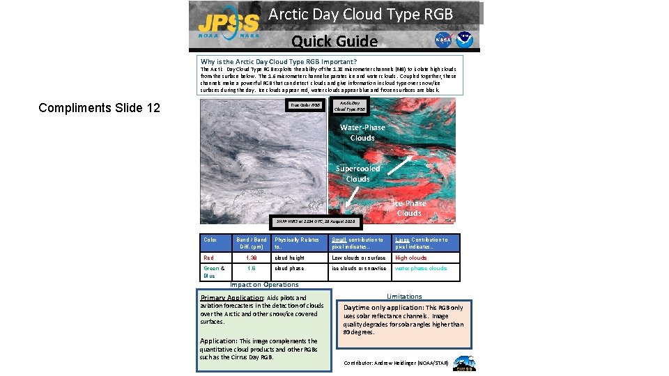
Arctic Day Cloud Type RGB Quick Guide Why is the Arctic Day Cloud Type RGB Important? The Arctic Day Cloud Type RGB exploits the ability of the 1. 38 micrometer channels (M 9) to isolate high clouds from the surface below. The 1. 6 micrometer channel separates ice and water clouds. Coupled together, these channels make a powerful RGB that can detect clouds and give information in cloud type over snow/ice surfaces during the day. Ice clouds appear red, water clouds appear blue and frozen surfaces are black. Compliments Slide 12 True Color RGB Thin Ice Arctic Day Cloud Type RGB Water-Phase. Low Clouds Thick Ice Supercooled Clouds How is the [Product Name] Created? Or [Product] RGB Recipe SNPP VIIRS at 2254 UTC, 28 August 2018 Color Band / Band Diff. (µm) Red Green & Blue Ice-Phase Clouds Physically Relates to… Small contribution to pixel indicates… Large Contribution to pixel indicates… 1. 38 cloud height Low clouds or surface High clouds 1. 6 cloud phase ice clouds or snow/ice water phase clouds Impact on Operations Primary Application: Aids pilots and aviation forecasters in the detection of clouds over the Arctic and other snow/ice covered surfaces. Application: This image complements the quantitative cloud products and other RGBs such as the Cirrus Day RGB. Limitations Daytime only application: This RGB only uses solar reflectance channels. Image quality degrades for solar angles higher than 80 degrees. Contributor: Andrew Heidinger (NOAA/STAR)