JOINT TYPHOON WARNING CENTER 2014 YEAR IN REVIEW
- Slides: 29

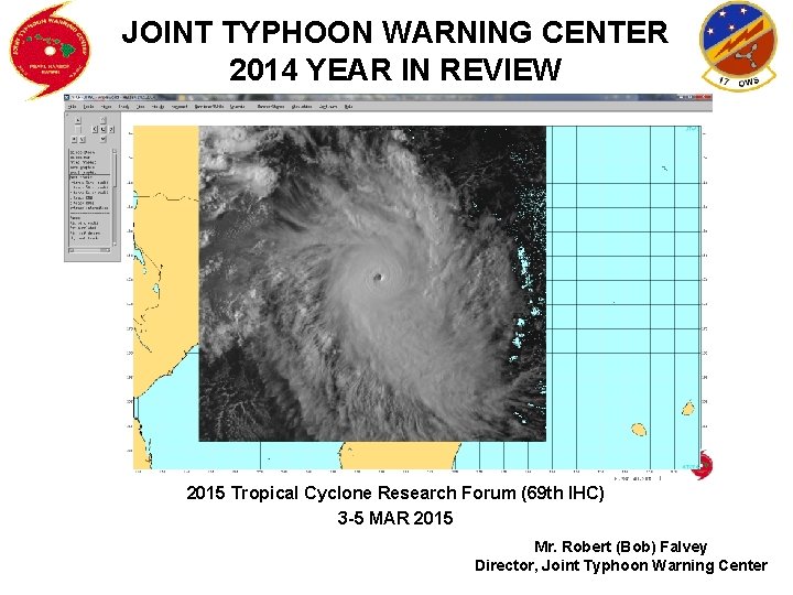
JOINT TYPHOON WARNING CENTER 2014 YEAR IN REVIEW 2015 Tropical Cyclone Research Forum (69 th IHC) 3 -5 MAR 2015 Mr. Robert (Bob) Falvey Director, Joint Typhoon Warning Center

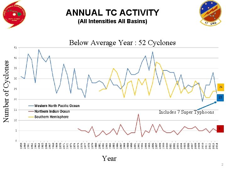
ANNUAL TC ACTIVITY (All Intensities All Basins) Number of Cyclones Below Average Year : 52 Cyclones Includes 7 Super Typhoons Year 2

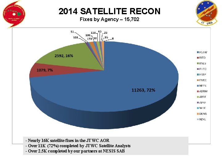
2014 SATELLITE RECON Fixes by Agency – 15, 702 - Nearly 16 K satellite fixes in the JTWC AOR - Over 11 K (72%) completed by JTWC Satellite Analysts - Over 2. 5 K completed by our partners at NESIS SAB DMSP F-15 25 May 11 0812 Z

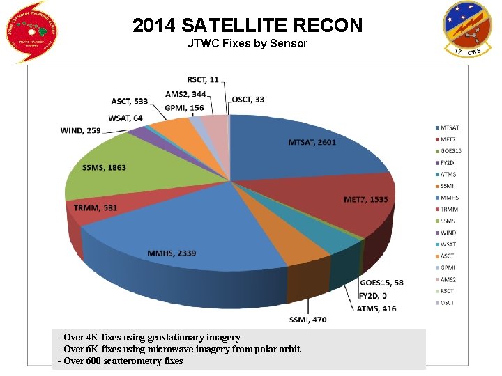
2014 SATELLITE RECON JTWC Fixes by Sensor - Over 4 K fixes using geostationary imagery - Over 6 K fixes using microwave imagery from polar orbit - Over 600 scatterometry fixes DMSP F-15 25 May 11 0812 Z

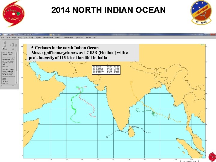
2014 NORTH INDIAN OCEAN - 5 Cyclones in the north Indian Ocean - Most significant cyclone was TC 03 B (Hudhud) with a peak intensity of 115 kts at landfall in India

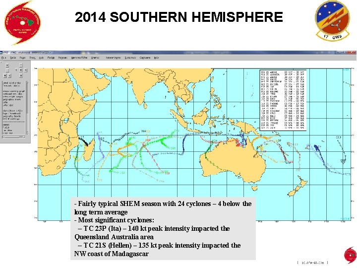
2014 SOUTHERN HEMISPHERE - Fairly typical SHEM season with 24 cyclones – 4 below the long term average - Most significant cyclones: -- TC 23 P (Ita) – 140 kt peak intensity impacted the Queensland Australia area -- TC 21 S (Hellen) – 135 kt peak intensity impacted the NW coast of Madagascar

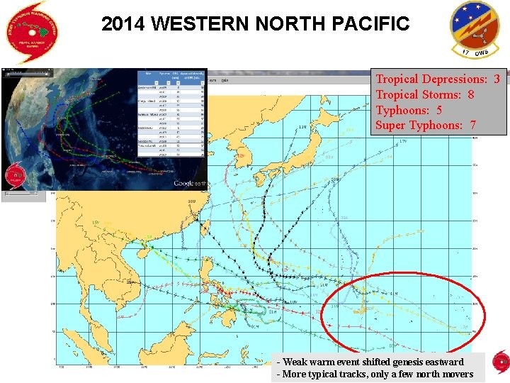
2014 WESTERN NORTH PACIFIC Tropical Depressions: 3 Tropical Storms: 8 Typhoons: 5 Super Typhoons: 7 - Weak warm event shifted genesis eastward - More typical tracks, only a few north movers

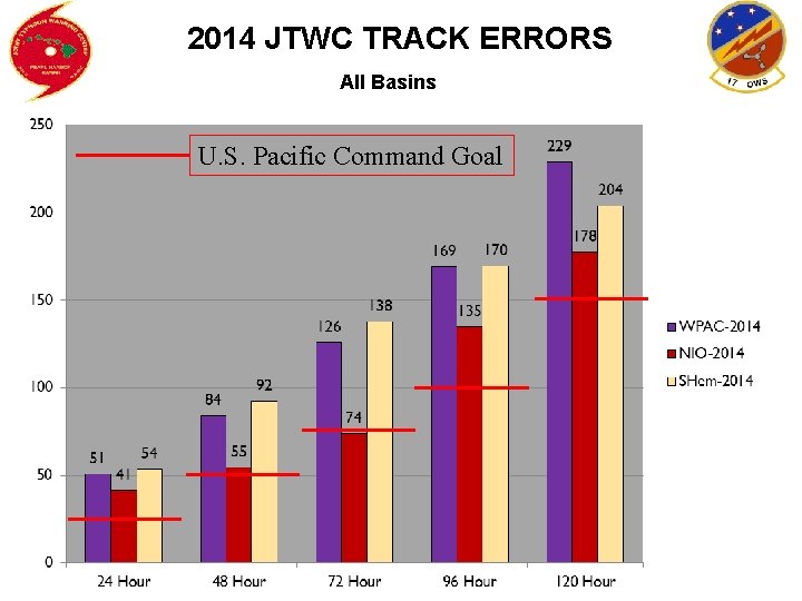
2014 JTWC TRACK ERRORS All Basins U. S. Pacific Command Goal

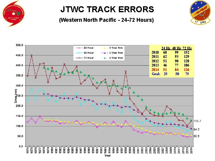
JTWC TRACK ERRORS (Western North Pacific - 24 -72 Hours) 2010 2011 2012 2013 2014 Goal: 24 Hr 48 Hr 60 99 62 93 51 90 46 77 51 84 25 50 72 Hr 152 129 128 106 126 75

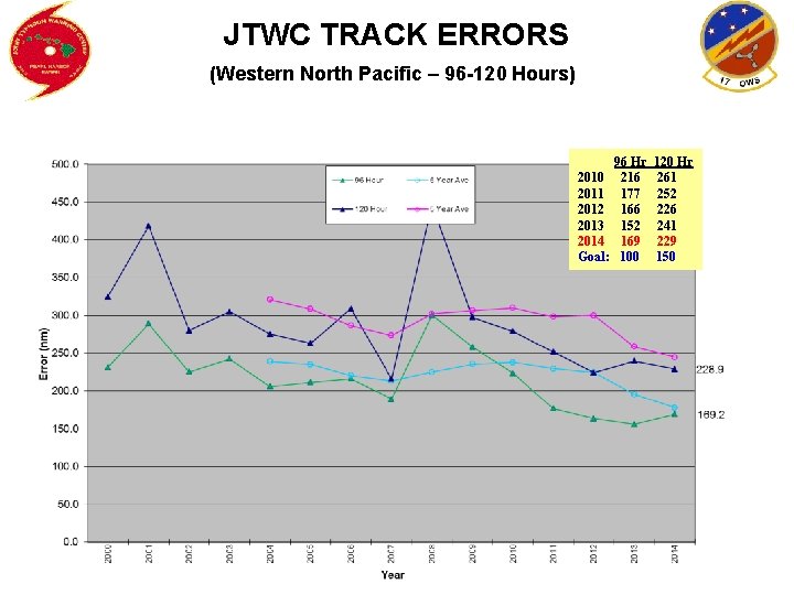
JTWC TRACK ERRORS (Western North Pacific – 96 -120 Hours) 2010 2011 2012 2013 2014 Goal: 96 Hr 216 177 166 152 169 100 120 Hr 261 252 226 241 229 150

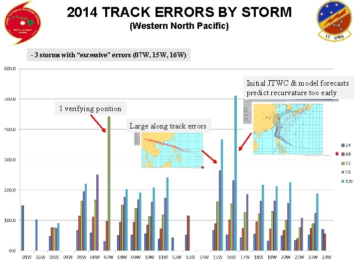
2014 TRACK ERRORS BY STORM (Western North Pacific) - 3 storms with “excessive” errors (07 W, 15 W, 16 W) Initial JTWC & model forecasts predict recurvature too early 1 verifying position Large along track errors

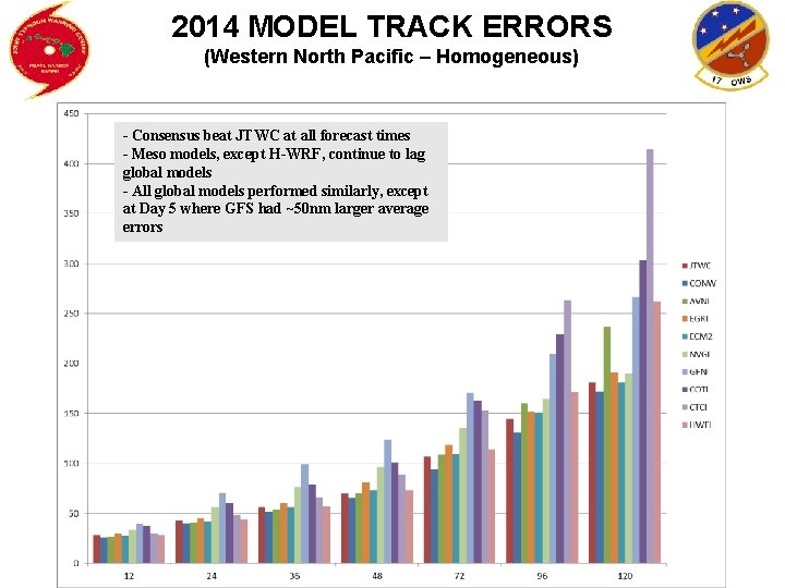
2014 MODEL TRACK ERRORS (Western North Pacific – Homogeneous) - Consensus beat JTWC at all forecast times - Meso models, except H-WRF, continue to lag global models - All global models performed similarly, except at Day 5 where GFS had ~50 nm larger average errors

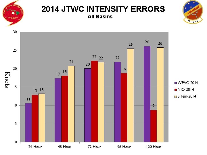
2014 JTWC INTENSITY ERRORS All Basins Knots

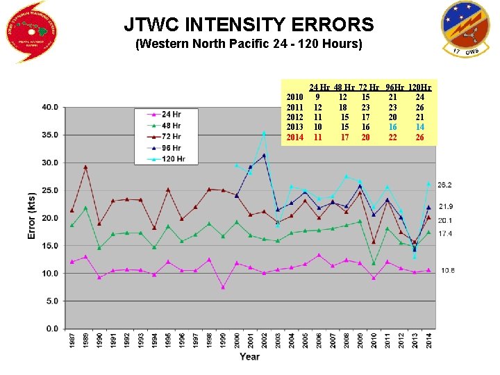
JTWC INTENSITY ERRORS (Western North Pacific 24 - 120 Hours) 2010 2011 2012 2013 2014 24 Hr 48 Hr 9 12 12 18 11 15 10 15 11 17 72 Hr 96 Hr 120 Hr 15 21 24 23 23 26 17 20 21 16 16 14 20 22 26

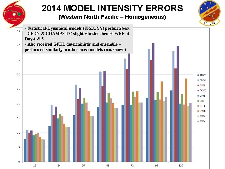
2014 MODEL INTENSITY ERRORS (Western North Pacific – Homogeneous) - Statistical-Dynamical models (S 5 XX/YY) perform best - GFDN & COAMPS-TC slightly better then H-WRF at Day 4 & 5 - Also received GFDL deterministic and ensemble – performed similarly to other meso models (not shown)

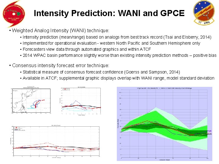
Intensity Prediction: WANI and GPCE • Weighted Analog Intensity (WANI) technique: • Intensity prediction (mean/range) based on analogs from best track record (Tsai and Elsberry, 2014) • Implemented for operational evaluation - western North Pacific and Southern Hemisphere only • Forecasters view data through automated graphics and within ATCF • 2014 WPAC basin performance slightly worse than existing intensity prediction methods – positive bias • Consensus intensity forecast error technique: • Statistical measure of consensus forecast confidence (Goerss and Sampson, 2014) • Available in ATCF; supplemental graphic displays overlap with WANI range, model standard deviation

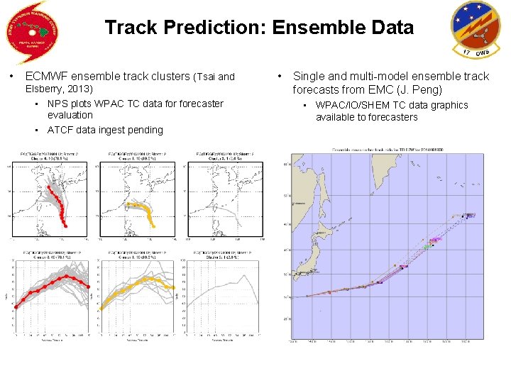
Track Prediction: Ensemble Data • ECMWF ensemble track clusters (Tsai and Elsberry, 2013) • NPS plots WPAC TC data forecaster evaluation • ATCF data ingest pending • Single and multi-model ensemble track forecasts from EMC (J. Peng) • WPAC/IO/SHEM TC data graphics available to forecasters 113 343 86 94 41 93 42

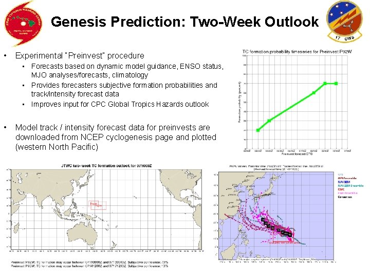
Genesis Prediction: Two-Week Outlook • Experimental “Preinvest” procedure • Forecasts based on dynamic model guidance, ENSO status, MJO analyses/forecasts, climatology • Provides forecasters subjective formation probabilities and track/intensity forecast data • Improves input for CPC Global Tropics Hazards outlook • Model track / intensity forecast data for preinvests are downloaded from NCEP cyclogenesis page and plotted (western North Pacific)

OTHER PROJECTS/EVENTS • • • AWIPS-2 GFDN upgrade COAMPS-TC upgrade H-WRF runs to move to NCEP production JTWC Public website move to NDBC – available soon – https: //metoc. ndbc. noaa. gov/JTWC

Contact Info • Commanding Officer CAPT Steven Sopko steven. sopko@navy. mil (808) 471 -0363 • Operations Officer (JTOPS) LT Thomas Mills thomas. j. mills@navy. mil (808) 471 -4597 • Director Mr. Robert Falvey robert. falvey@navy. mil (808) 474 -5301 • Technical Services Mr. Matt Kucas matthew. kucas@navy. mil (808) 471 -4597 • Satellite Operations Flight Capt Brian De. Cicco brian. decicco@navy. mil (808) 474 -3946

JOINT TYPHOON WARNING CENTER 2014 YEAR IN REVIEW ? ? QUESTIONS? ?

BACKUP SLIDES

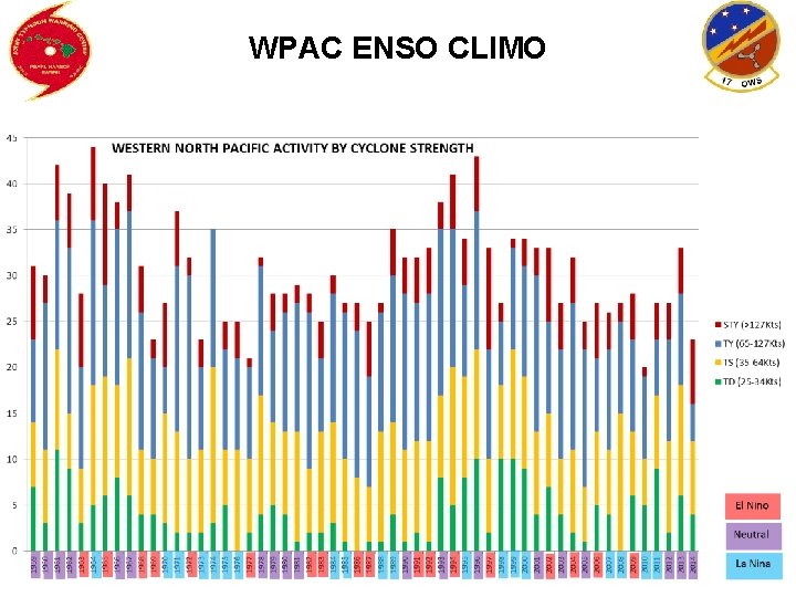
WPAC ENSO CLIMO

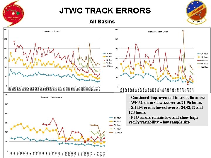
JTWC TRACK ERRORS All Basins - Continued improvement in track forecasts - WPAC errors lowest ever at 24 -96 hours - SHEM errors lowest ever at 24, 48, 72 and 120 hours - NIO errors remain low and show high yearly variability – low sample size

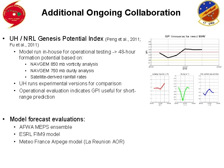
Additional Ongoing Collaboration • UH / NRL Genesis Potential Index (Peng et al. , 2011; Fu et al. , 2011) • Model run in-house for operational testing -> 48 -hour formation potential based on: • NAVGEM 850 mb vorticity analysis • NAVGEM 750 mb du/dy analysis • Satellite-derived rainfall rates • UH runs experimental versions for comparison • Operational evaluation indicates GPI useful for shortrange prediction • Model forecast evaluations: • AFWA MEPS ensemble • ESRL FIM 9 model • Meteo France Arpege model (La Reunion AOR)

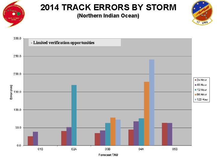
2014 TRACK ERRORS BY STORM (Northern Indian Ocean) - Limited verification opportunities

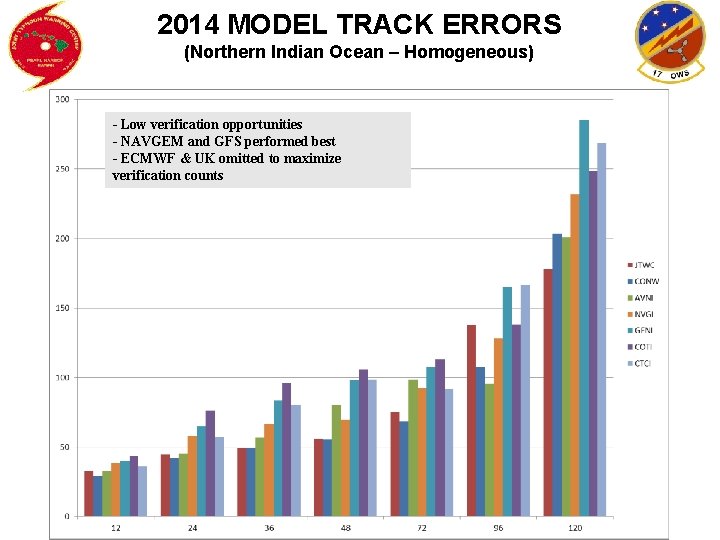
2014 MODEL TRACK ERRORS (Northern Indian Ocean – Homogeneous) - Low verification opportunities - NAVGEM and GFS performed best - ECMWF & UK omitted to maximize verification counts

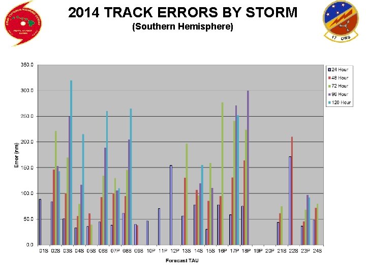
2014 TRACK ERRORS BY STORM (Southern Hemisphere)

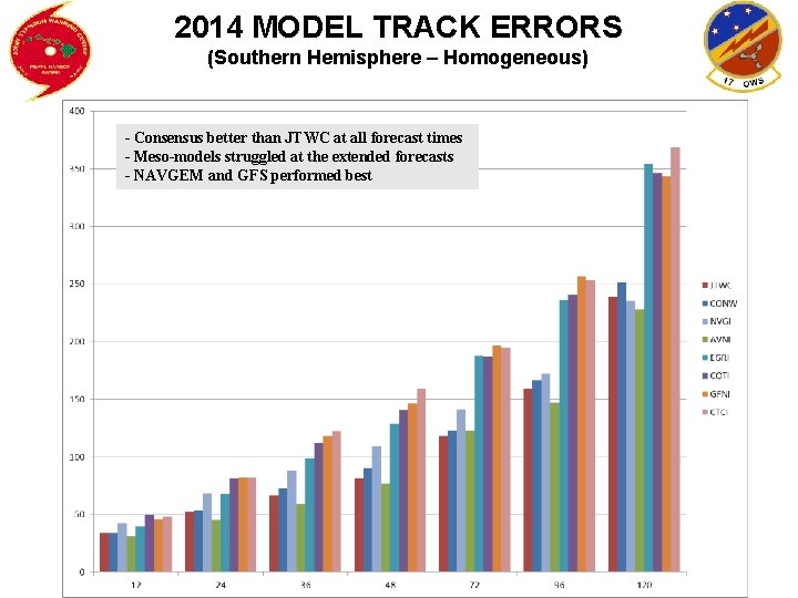
2014 MODEL TRACK ERRORS (Southern Hemisphere – Homogeneous) - Consensus better than JTWC at all forecast times - Meso-models struggled at the extended forecasts - NAVGEM and GFS performed best