Isotope technology interventions for better management of groundwater

Isotope technology interventions for better management of groundwater resources Tirumalesh Keesari Isotope Hydrology Section, IRAD Bhabha Atomic Research Centre, Mumbai tirumal@barc. gov. in 022 -25593162

Outline Ø Environmental isotopes- what are they? Ø What are the commonly used isotopes? Ø How do isotopes provide answers? Ø Solving hydrological problems through isotopes technology – some investigations

What are Environmental Isotopes? Isotopes of water : H 2 O 1 H, 2 H, 3 H, 16 O, 17 O, 18 O Ø Isotopes – same Atomic Number, different Mass Number 18 types of water molecules 106 Ø Both Stable and Unstable (Radioactive) Ø Naturally present so environmental Other stable isotopes q C-13, N-15, S-34 9, 97, 700 Environmental radioisotopes Total mass = 18 v H-3 (half life: 12. 3 years) 300 q B-11, Sr-82…. many more v C-14 (half life: 5730 years) Total mass = 19 How are isotopes useful? ü Stable isotopes – markers of water molecules ü Radioisotopes – residence time 2000 isotope fingerprint Total mass = 20 a b u n d a n c e

How water molecules get different isotope signatures? Isotopic fractionation q light water easy evaporation, Heavy water easy condensation Controlling factors OCEAN q Season (NEM, SWM, WD) q Distance from coast q Altitude q Amount 18 O/16 O = 0. 001995 18 O/16 O = 0. 002000

Water molecules record the information about their origin and path in their isotopic composition through isotopic ratios Condensation: T & Rh Cloud Rain Snow Evaporation: T & Rh Groundwater d of source water River

Hydrological Investigations Magic diagram ü Source of groundwater ü Surface water - groundwater interconnection ü Identification of recharge altitude/zone of springs ü Hydrograph separation ü Groundwater residence time ü Paleochannel and paleoclimate investigations ü Estimation of groundwater velocity and direction

Isotope Investigations Hydrograph separation Identification of recharge altitude/zone of springs Paleochannel studies Arsenic contamination Sustainability of deep groundwater Groundwater recharge studies Groundwater salinization Surface water - groundwater interconnection Groundwater salinization Fluoride contamination Geothermal waters

Isotope hydrochemical investigation in Buldhana District, Maharashtra Problem: Depleting groundwater levels, nitrate contamination Koradi Dam Pentakli Dam Isotope, hydrochemistry and hydrogeology confirm the presence of two aquifer systems in the study area with limited hydraulic connectivity 5% Surface water, 15% rainfall, 80% irrigation return flow AKRUTI programme) (Advance Knowledge and RUral Technology Implementation’ 8

Recharging the drying springs in mountainous regions • • In the mountainous regions, springs are the only available source of water for drinking, food production and other uses Uttarakhand (28 springs) and Himachal Pradesh (18 springs) Evaluating the isotopic signature of rainfall at different altitudes – correlating with spring values Water conservation and recharge structures are constructed at the identified sites

Gabion Check Dam Sub surface dyke low spring discharges Percolation Pond High spring discharges Construction of contour trench Contour trench

Evaluating utility of tanks in enhancing groundwater recharge in hard rock zones of Telangana Natural Tank uses: source to drinking water, irrigation supplies and augmenting the groundwater recharge in drought prone regions Studied Sites: 3 (2 desilted, 1 not desilted) Evaluate if tank desiltation is resulting in enhanced groundwater recharge

Outcome of isotope study § Wells in the vicinity of desilted tanks showed tank water isotope signature 1. 5 km downstream § Control site – upstream and down stream wells no significant isotopic difference § Lowered fluoride content (from 4 ppm to < 1. 5 ppm) § Community participation, extended to other villages Desiltation work § Similar Initiative: Mission Kakatiya, Telangana

Application of isotope techniques in aquifer mapping at a model project site in Patna district of Bihar state Objective: delineating sources of recharge to groundwater in shallow and deep aquifers Groundwater sampling in Patna • Son river sampling near Patna • Aquifer I (top) is getting relatively faster recharge and aquifer II (bottom) is receiving delay recharge. Aquifer I (Shallow groundwater) receives recharge from the River Punpun and Son while the aquifer II (deep groundwater) receives recharge from River Ganga.

Investigations on the Paleochannels in NW India Problem: Depleting GW levels Objective: To evaluate groundwater characteristics near paleochannel network

Ø Local precipitation recharging up to a depth of 100 m Ø Intermediate zones are mainly recharged by western disturbance Ø Deep most zone is paleowater, up to 8 000 -10, 000 years and represents high altitude recharge

Groundwater Salinization of Purna River Basin, Maharashtra �About 3, 000 km 2 area is underlain by saline groundwater (544 villages) �Electrical conductivity of groundwaters up to 30, 000 µS/cm Possible reasons of salinity �Intrusion of ancient sea, Evaporative enrichment in the past �Leaching / Dissolution of salts, Anthropogenic pollutants
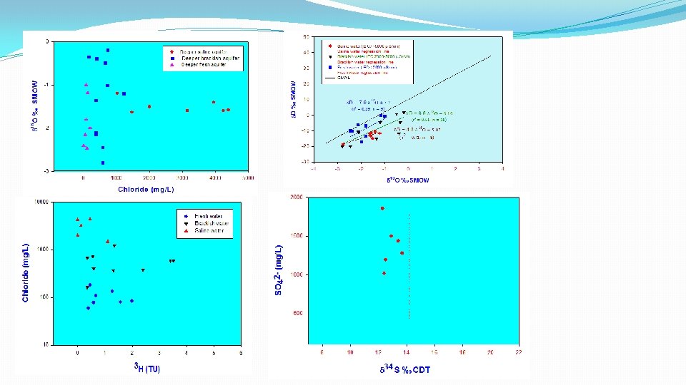

findings �A depleted starting isotopic composition for saline water samples w. r. t. present day surface waters - a different climatic condition during their recharge �Saline waters are 4 – 7 ka old and they are isolated �Brackish waters get partial recharge and these waters seems to be mixtures of old saline and modern fresh waters �Salts in saline groundwaters have a non- marine origin - terrestrial evaporatic source

Isotope Hydrological investigations on groundwaters of Challakere, KA • Semi arid region – 500 mm/ year • Due to over exploitation of the groundwater, most of the shallow wells have been dried up and abandoned ü All the aquifers are being recharged by precipitation ü Shallow and intermediate GW significant surface water contribution ü Residence time of the deep groundwater is ~ 5 -15 years

Assess the groundwater salinity in and around Kelwa and Mahim villages of Thane District, Maharashtra Problem: Rise in well water salinity near salt pans Groundwater Surveys and Development Agency (GSDA), Maharashtra. Salt pans at Kelwa, Thane Radiotracer experiment at Thane ü Salt pan activity not contributing to groundwater salinity ü Upconing of sea water due to over exploitation of freshwater groundwater ü Groundwater flow rate was estimated using radiotracer studies

Exploration of geothermal resources in Maharashtra Isotope techniques in conjunction with geochemical methods were employed to access the origin, age and reservoir temperature of the geothermal reservoir in 1. Ganeshpuri-Akloli and Jalgaon-Dhule (GSI, Nagpur) 2. Tural-Rajwadi (M/s Thermax, Pune), The main findings are: q Thermal water in all the areas are meteoric in origin. q The estimated reservoir temperature in Tural. Rajwadi: 150 ± 10 OC Ganeshpuri-Akloli: 130 ± 10 OC and Jalgaon-Dhule: 110 ± 15 OC. q The age of thermal water in Ganeshpuri area is ~100 years. Tural area : 13500± 1500 years (14 C dating). Location of hot springs Geothermal springs

Fluoride Contamination in Groundwaters of Ilkal Area, KA, India Possible sources of fluoride contamination 1. Rock polishing industrial wastes 2. Leaching of fluoride from the formation q Both shallow and deep groundwater are interconnected q Rock polishing industries contributing to fluoride contamination (7 ppm) q Delineated the zones contaminated by natural and anthropogenic sources Similar study in Talcher, Angul District Fluride is mostly due to geogenic sources and minimal contamination from industrial wastes

Source and origin of groundwater pollutants and their flow at Indian Rare Earths Ltd. (IRE), Udyogamandal, Kerala, India Ø Contamination is found to be emerging from southern part of the IRE site and not from the in-house activities Ø The possible source for these contaminants appears to be FACT industry
 Isotope Ratio Mass Spectrometer Uranium")
Ion Chromatography - Major cations, anions analysis (< 5%) Isotope Ratio Mass Spectrometer Uranium Analyser

Delayed coincidence counter- 223 Ra and 224 Ra in water samples Smart Radon Monitor Liquid Scintillation Counter Alpha spectrometer -

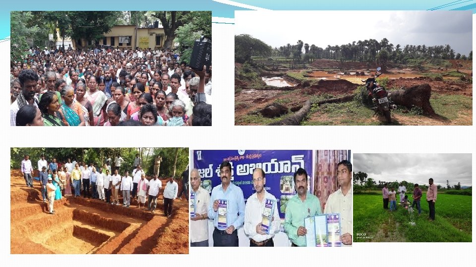
Jal Shakti Abhiyan �Launch: 1 st July 2019 �Purpose: Water conservation and water security �Focus areas: Water Stressed Districts/Blocks (256 districts) �Campaign: 1 st July to 15 th Sept (Phase 1), 1 st Oct to 30 th Nov (Phase 2) �Intervention Areas - 5 Water conservation and rainwater harvesting Renovation of traditional and other water bodies/tanks Reuse and recharge structures Watershed development Intensive afforestation

Isotope investigation on groundwater recharge mechanism and evaluating the efficacy of recharge structures in Srikakulam District, A. P. § § § Water scarce mandals – Laveru, G. Singdam, Ranasthalam About 3000 natural tanks in 3 mandals Tank desiltation under minor tank irrigation scheme Work done so far Reconnaissance survey during July 2019 Collection of geological and hydrogeological information Selection of sites and first set of sampling Aug 2019 Isotope and chemical measurements are in progress Future work Measurement of rainwater samples for isotopes Data interpretation Second set of sampling and measurements Final report with recommendations

Precaution v Isotopes are not independent tools v Applied in conjunction with geophysical, hydrogeological and geochemical information Fretwell’s Law “Warning! isotope data may cause severe and contagious stomach upset if taken alone. Acknowledgement § Support and encouragement from authorities (Chairman DAE, Director BARC, AD, RC&IG) § All our collaborators (CGWB, GSDA, NIH, HESCO, CWRDM, PRL, PWD, Universities, IITs, NGOs)
 Laser Isotope Analyser (75")
Setting up an Isotope Hydrology Laboratory Ion Chromatograph (50 Lakhs) Laser Isotope Analyser (75 Lakhs) Liquid Scintillation Counter (150 Lakhs) Multi-parameter water testing kit (1 -2 Lakhs) Isotope Ratio Mass Spectrometer (125 Lakhs)

Isotope investigation on dry regions of Amaravati Maharashtra State Issues: • Low groundwater potential • Salinity issues • Drastic decline in groundwater levels Isotope findings: Major water source - Chinchona hill range Weak fracture zone – best location for well field development, yield ~30, 000 L/h Major source of recharge southwest monsoon AKRUTI programme (Advance Knowledge and RUral Technology Implementation’ programme)

Before Intervention After Intervention BARC Isotope Hydrology Team Copyright 2009, BARC

Efficacy of water conservation measures Problem Effectiveness of artificial recharge structures at Hinganigada Tank (Maharashtra) Major findings Hinganigada tank, Pune The artificial recharge structures were found to be effective and impact is noticed up to 2. 2 kms from the Dam
 Understanding groundwater")
Isotope hydrogeological investigation at Chiplun, Khed and Guhaghar Blocks of Maharashtra i) Understanding groundwater recharge to shallow groundwater ii) Groundwater pollution and salinization along the near-shore and creek areas of Khed Taluk iii) Rejuvenation of drying springs at Guhaghar Taluk. This investigation was carried out in collaboration with the Parivartan, NGO, under AKRUTI programme (Advance Knowledge and RUral Technology Implementation’ programme) A study on the freshening of seawater in Mahim coast, Mumbai Measurement of EC and radon concentrations indicate that shallow groundwater influx is the cause for the freshening of seawater and not submarine groundwater discharge (SGD). This was carried out in collaboration with NEERI, Mumbai
 near Pune,")
Isotope hydrological investigations for watershed development of Walki River Basin (Kolwan Valley) near Pune, Maharashtra This study shows that shallow bore wells located on the left side of the check dam were not linked with check dam and receive only base flow whereas the shallow bore wells on the right side of the check dam receive ~33% contribution from the check dam. This study was carried out with Advanced Center for Water Resources Development and Management, Pune Isotope investigation on approach tunnel seepage of Ghatghar pumped storage Hydroelectric project in Shahpur, Thane Dist. Maharashtra Isotopic study (2 H, 18 O, 3 H) conclusively proved that the springs at the transformer cavern approach tunnel junction originate from the lower reservoir whereas the arch roof springs receive contribution from, both, the lower reservoir and percolating rainwater through the overburden basaltic formation during rainy season.

Dam seepage studies Chaskaman Dam: Interconnection between boils and reservoir were established. Filtration velocity was in the range of 0. 1 to 4. 0 m/d. Seepage zone was at about 60 m depth from the top of the dam. Borda reservoir: Seepage was through the reservoir bed It was along the two streams feeding the reservoir Poip Dam: Groundwater velocity was in the range of 0. 1 to 14. 4 m/d Direction of seepage was towards the natural stream Most of the seepage occurred was through the reservoir bed
- Slides: 37