Islamic University of Gaza Civil Engineering Department Surveying


- Slides: 16
Islamic University of Gaza Civil Engineering Department Surveying II ECIV 2332 By Belal Almassri
Chapter 7 Coordinate geometry and traverse surveying – Part 2 -Resection -Traverse Surveying Definitions -Types, Utilizations and advantages -Computations and correction errors -Examples
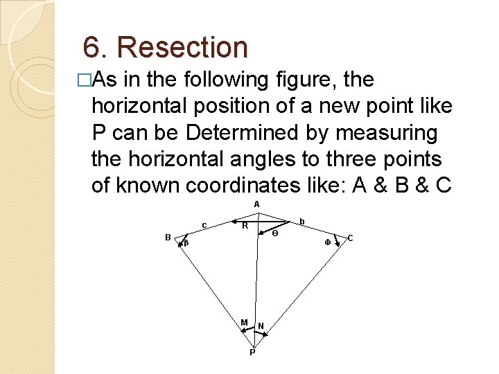
6. Resection �As in the following figure, the horizontal position of a new point like P can be Determined by measuring the horizontal angles to three points of known coordinates like: A & B & C A c B b R Ө β M N P Ф C
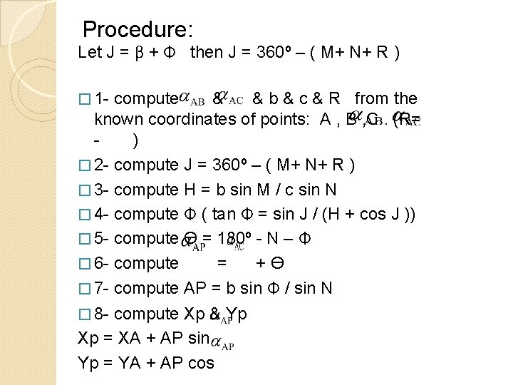
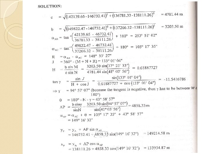
Procedure: Let J = β + Ф then J = 360º – ( M+ N+ R ) � 1 - compute & & b & c & R from the known coordinates of points: A , B , C. (R= ) � 2 - compute J = 360º – ( M+ N+ R ) � 3 - compute H = b sin M / c sin N � 4 - compute Ф ( tan Ф = sin J / (H + cos J )) � 5 - compute Ө = 180º - N – Ф � 6 - compute = +Ө � 7 - compute AP = b sin Ф / sin N � 8 - compute Xp & Yp Xp = XA + AP sin Yp = YA + AP cos
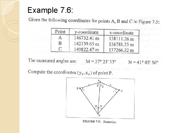
Example 7. 6:
Traverse Surveying Definitions: - Traverse is one of the most commonly used methods for determining the relative positions of a number of survey points. - Traverse is a method in the field of surveying to establish control networks. It is also used in geodetic work. Traverse networks involved placing the survey stations along a line or path of travel, and then using the previously surveyed points as a base for
Utilizations: - property survey to establish boundaries. - Location and construction layout surveys for highways, railways and other works. - Helps the surveys for photogrammetric mapping. Types of Traverse: a- Closed Traverse b- Open Traverse
Advantages: - Less organization needed. - Few observations needed. - More accurate than other methods. - Suits different types of utilizations Open Vs Closed: - Closed traverse is useful in marking the boundaries of wood or lakes. - Open traverse is utilised in plotting a strip of land which can then be used to plan a route in road construction.
�Choice 1. 2. 3. 4. of traverse stations: As close as possible to the survey details. Traverse shortest line should be greater than 1/3 of the longest line (preferred to be equal). Traverse stations should be selected in firm ground. From one station we can see the back sight and the foresight.
Underground. .
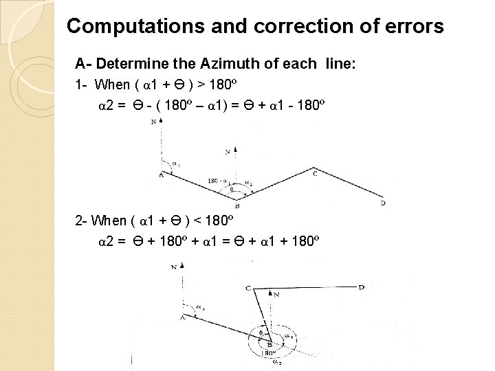
Computations and correction of errors A- Determine the Azimuth of each line: 1 - When ( α 1 + Ө ) > 180º α 2 = Ө - ( 180º – α 1) = Ө + α 1 - 180º 2 - When ( α 1 + Ө ) < 180º α 2 = Ө + 180º + α 1 = Ө + α 1 + 180º
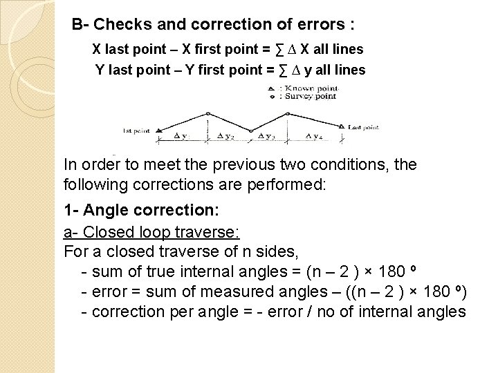
B- Checks and correction of errors : X last point – X first point = ∑ ∆ X all lines Y last point – Y first point = ∑ ∆ y all lines In order to meet the previous two conditions, the following corrections are performed: 1 - Angle correction: a- Closed loop traverse: For a closed traverse of n sides, - sum of true internal angles = (n – 2 ) × 180 º - error = sum of measured angles – ((n – 2 ) × 180 º) - correction per angle = - error / no of internal angles
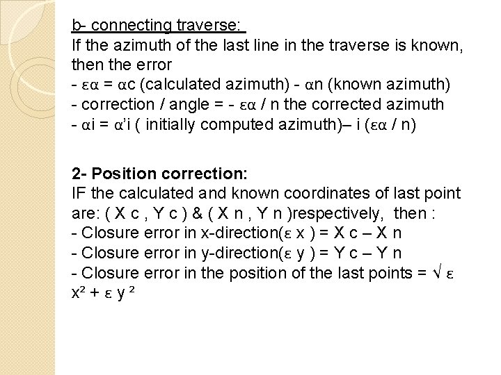
b- connecting traverse: If the azimuth of the last line in the traverse is known, then the error - εα = αc (calculated azimuth) - αn (known azimuth) - correction / angle = - εα / n the corrected azimuth - αi = α’i ( initially computed azimuth)– i (εα / n) 2 - Position correction: IF the calculated and known coordinates of last point are: ( X c , Y c ) & ( X n , Y n )respectively, then : - Closure error in x-direction(ε x ) = X c – X n - Closure error in y-direction(ε y ) = Y c – Y n - Closure error in the position of the last points = √ ε x² + ε y ²
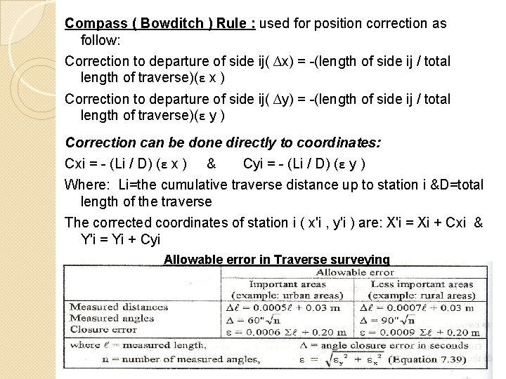
Compass ( Bowditch ) Rule : used for position correction as follow: Correction to departure of side ij( ∆x) = -(length of side ij / total length of traverse)(ε x ) Correction to departure of side ij( ∆y) = -(length of side ij / total length of traverse)(ε y ) Correction can be done directly to coordinates: Cxi = - (Li / D) (ε x ) & Cyi = - (Li / D) (ε y ) Where: Li=the cumulative traverse distance up to station i &D=total length of the traverse The corrected coordinates of station i ( x'i , y'i ) are: X'i = Xi + Cxi & Y'i = Yi + Cyi Allowable error in Traverse surveying
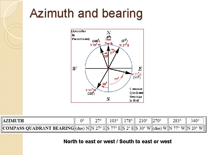
Azimuth and bearing North to east or west / South to east or west