Introduction to the Global Positioning System GPS GPS
")
Introduction to the Global Positioning System (GPS)
 • GPS ---- What it is and what it does.")
GPS (Global Positioning Systems) • GPS ---- What it is and what it does. – worldwide radio-navigation system formed from a constellation of 24 satellites and their base stations on the ground. – calculates position on earth – gives position in the form of (x, y, z) coordinates or latitude, longitude, and elevation

GPS Quick Facts • GPS development began in the 1970’s as part of the DOD’s Defense Navigation Satellite System • First NAVSTAR satellites were launched in the late 1970 s • First testing of GPS ground equipment began in the early 1980 s • Full use of GPS signal by civilians was blocked until 02 MAY 2000, when Selective Availability was deactivated

Before GPS • Landmarks: Only work in local area. Subject to movement or destruction by environmental factors. • Dead (Ded) Reckoning: Very complicated. Accuracy depends on measurement tools which are often relatively crude. Errors accumulate quickly. • Celestial: Complicated and only works at night in good weather. Limited precision. • LORAN: Limited coverage (mostly coastal). Accuracy variable, affected by geographic situation. Easy to jam or disturb.

How GPS Works • 24 satellite system, orbiting at 10, 900 NM and monitored by five ground stations • GPS works through signal triangulation (really trilateration) • Four visible satellites are needed for a good positional fix

How GPS Works

Accuracy and Precision Accurate Precise Accurate & Precise

GPS Accuracy and Precision • General use units are accurate to about plus or minus 15 meters (before SA was deactivated this was 100 meters) • General use units with WAAS capability are accurate to plus or minus 5 -6 meters • Differential GPS is accurate to as little as 5 centimeters with post processing • Military hand units are accurate to about 1 -2 meters with no augmentation

Errors and the DOPs • The Major Error Types – Ephemeris – Atmospheric – Multipath • Errors are calculated as Dilutions Of Precision (DOP)

Types of DOPs

Projections and Datums • A projection is a representation of the curved surface of the earth on a flat surface. – It involves the use of mathematical transformations between the location of places on the earth and their projected locations on the plane. • Datums - define the origin and orientation of the coordinate system used. – NAD 27, NAD 83, WGS 84

Latitude and Longitude • Latitude – North of Equator is positive, South is negative • Longitude – West of the Meridian is negative, East is positive
 •")
Latitude and Longitude • Can be expressed as: – Degrees, minutes, seconds (DMS) • 34 o 15’ 45” N x 119 o 05’ 15” W – Degrees, decimal minutes (DMm) • 34 o 15. 750 N x 119 o 05. 250 W – Decimal Degrees (Dd) • 34. 2625 x -119. 0875

Your GPS Receiver • Trimble’s Geo. Explorer 3 or Geo. Explorer II

GIS - A Thinker’s Tool

With GIS, you can explore any topic that involves locations. You can analyze how it relates to other conditions of a given place, or to similar features in other places. For instance. . . SYHS GIS Lab GIS - A Thinker's Tool 4

• When high numbers of deformed frogs are found, what characteristics, near or far, might influence this? ESRI Schools & Libraries GIS - A Thinker's Tool 5

• Where recent turmoil has uprooted a population, how might surrounding regions have contributed to the situation, and how might they respond? SYHS GIS LAB GIS - A Thinker's Tool 7

• When controversy about a facility threatens to tear a community apart, how can they visualize the information and evaluate the alternatives? SYHS GIS Lab GIS - A Thinker's Tool 8

• When a scourge strikes and spreads, where can barriers be erected effectively to limit its expansion? SYHS GIS Lab GIS - A Thinker's Tool 9

GIS allows bringing together disparate data from diverse fields. Users must wrestle with: data relevance n data quality n analyses used n relationships identified n interpretations drawn n SYHS GIS LAB GIS - A Thinker's Tool 10

The process of GIS n n n n Think about a place or a topic. . . Ask a question about it. . . Make a map. . . Explore the patterns that appear. . . Enhance the data or modify the analysis. . . Ask a new question … repeat. . . SYHS GIS LAB GIS - A Thinker's Tool 12

GIS and GPS • GIS is a system in • • which information on location is found. GPS is a system in which the information is placed on a map. To the right is an example of the two working together.

Santa Ynez High GIS Department

Arc. View provides data visualization, query, analysis, and integration capabilities along with the ability to create and edit geographic data. ESRI Arc. View

MFWorks by Keigan Systems represents an easy to use tool box for the analysis and visualization of spatial data. Students can find relationships in collected GIS data and plot it on a grid map: MFWorks for Geo. Media
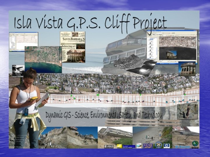

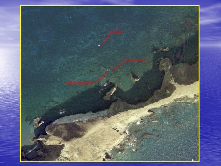
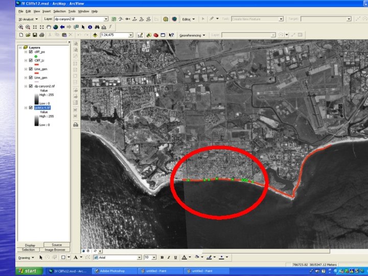
ISLA Vista Cliff Mapping

Adrian Evarts Maps Trails for UCSB Docents Trails Mapped for Docents to use as trainings and guides for field trips

EAST works with: SYV Water Conservation District Mapping Ballard

Plotting the Points We went out onto HWY 154 and using the Geo. Explorer 3, Plotted the location of all the accidents. When we got back to the EAST Lab we transferred all the plotted points onto a map of HWY 154. The map shows where each accident took place, as well as the cause, and other useful information. All the information that we have collected and put together will soon be up for public access.

Andrew Murray Vineyard Project Andrew Murray Vineyards came to the EAST Lab for help mapping the grape vines of their vineyard. We took a team of about 5 people went out to the vineyard. Using the Geo. Explorer 3 we walked around all the grapevine patches and plotted points. The vineyard was beautiful and we had a lot of fun.

Murray Vineyards

Mapping of Ballard Water District

Water District
 Waters h")
EAST works on coastal water quality and surf spots Study Region (50) Waters h eds rangin g from 10 -5 0 km 2 Santa Barbara Channel Ventura River, 590 km 2 Santa Clara River, 4200 km 2 Los Angeles, CA Multi-source Land Cover Data (2002 v 1) California Department of Forestry and Fire Protection

MBARI Monterey Bay Multibeam Survey 4 EAST Facilitators Spend 1 week together Using GIS Big Sur Pockmark Field

Geocoding of SYVUHS Students : by Kelly Lyon

FLASH! Students find Dam Site!

Santa Ynez Valley High School Dynamic GIS – Geography, History, Conservation
- Slides: 46