Introduction to the Forecast Impact and Quality Assessment


- Slides: 26

Introduction to the Forecast Impact and Quality Assessment Section GSD Verification Summit Meeting 8 September 2011 Jennifer Mahoney 1

FIQAS Team �Paul Hamer �Joan Hart �Mike Kay �Steve Lack �Geary Layne �Andy Lough �Nick Matheson �Missy Petty �Brian Pettegrew �Dan Schaffer �Matt Wandishin 2

FIQAS - Overview Mission Advance the understanding and use of weather information through impact-based assessments and targeted information delivery to benefit decision making in response to high impact weather events Forecast quality information in context 3

FIQAS - Overview �Activities �Perform in-depth quality assessments � Develop and apply verification metrics and methodologies � Assess and integrate observation datasets into verification approaches �Generate and maintain historical performance records �Develop and transition verification tools for information delivery � Users � Forecasters �Roles �Quality Assessment Product Development Team � Assessments for FAA product transition �Forecast Impact and Quality Assessment Section (FIQAS) � Verification tool transition � Assessment and guidance to NWS Aviation Services and Performance Branches 4

FIQAS Overview �Current - Weather variables of interest �Ceiling and visibility �Icing �Convection/precipitation �Turbulence �Cloud top height �Echo tops 5

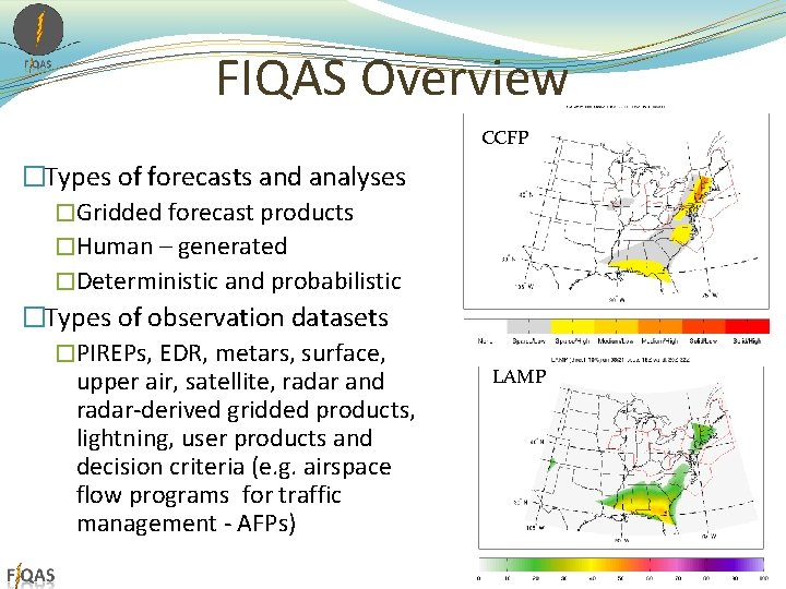
FIQAS Overview CCFP �Types of forecasts and analyses �Gridded forecast products �Human – generated �Deterministic and probabilistic �Types of observation datasets �PIREPs, EDR, metars, surface, upper air, satellite, radar and radar-derived gridded products, lightning, user products and decision criteria (e. g. airspace flow programs for traffic management - AFPs) LAMP 6

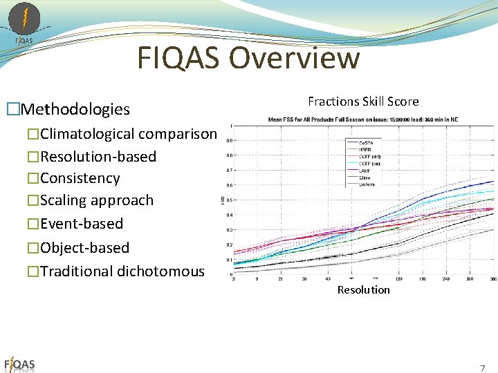
FIQAS Overview �Methodologies �Climatological comparisons �Resolution-based �Consistency �Scaling approach �Event-based �Object-based �Traditional dichotomous Fractions Skill Score Resolution 7

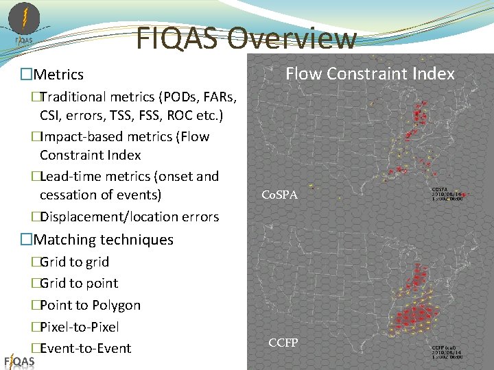
FIQAS Overview �Metrics Flow Constraint Index �Traditional metrics (PODs, FARs, CSI, errors, TSS, FSS, ROC etc. ) �Impact-based metrics (Flow Constraint Index �Lead-time metrics (onset and cessation of events) �Displacement/location errors Co. SPA �Matching techniques �Grid to grid �Grid to point �Point to Polygon �Pixel-to-Pixel �Event-to-Event CCFP 8

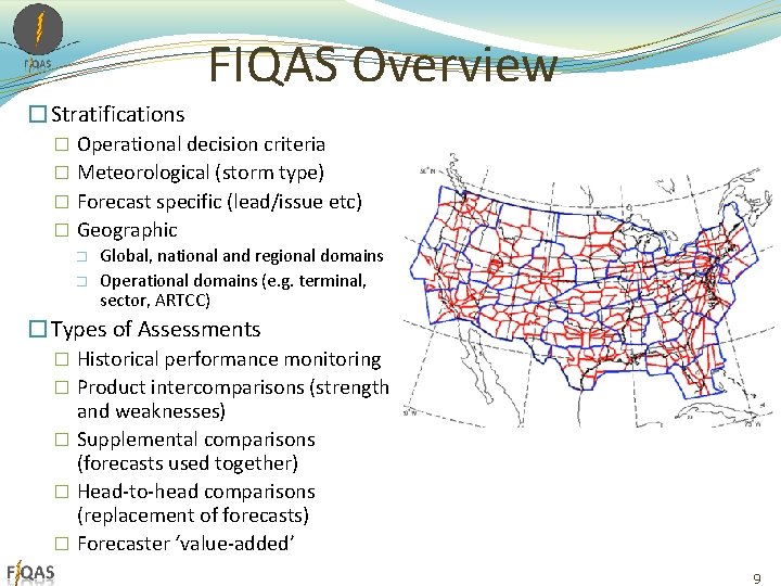
FIQAS Overview �Stratifications � Operational decision criteria � Meteorological (storm type) � Forecast specific (lead/issue etc) � Geographic � Global, national and regional domains � Operational domains (e. g. terminal, sector, ARTCC) �Types of Assessments � Historical performance monitoring � Product intercomparisons (strength and weaknesses) � Supplemental comparisons (forecasts used together) � Head-to-head comparisons (replacement of forecasts) � Forecaster ‘value-added’ 9

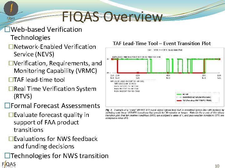
FIQAS Overview �Web-based Verification Technologies �Network-Enabled Verification TAF Lead-Time Tool – Event Transition Plot Service (NEVS) �Verification, Requirements, and Monitoring Capability (VRMC) �TAF lead-time tool �Real Time Verification System (RTVS) �Formal Forecast Assessments �Evaluate forecast quality in support of FAA product transitions �Evaluations for NWS feedback and funding decisions �Technologies for NWS transition 10

Presentations Today �FIQAS Verification Technologies – Missy Petty �An Object-based Technique for Verification of Convective Initiation - Steve Lack �More info at the FIQAS home page http: //esrl. noaa. gov/gsd/ab/fvs/ 11

Backup 12

Methodology Overview 13

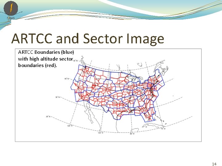
ARTCC and Sector Image ARTCC Boundaries (blue) with high altitude sector boundaries (red). 14

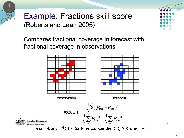
Fractions Skill Score (FSS) �High resolution forecasts often suffer when viewed with basic categorical skill scores (pixel-to-pixel-based verification) �The FSS accounts for spatial displacements between forecasts and observations (finds the benefit in high resolution products) �Used to bring products of varying types to a common playing field without changing product definitions �There is no need to threshold probabilities or coverages in LAMP or CCFP to turn them into dichotomous (yes/no) forecasts before scoring 15

From Ebert, 2 nd QPF Conference, Boulder, CO, 5 -8 June 2006 16

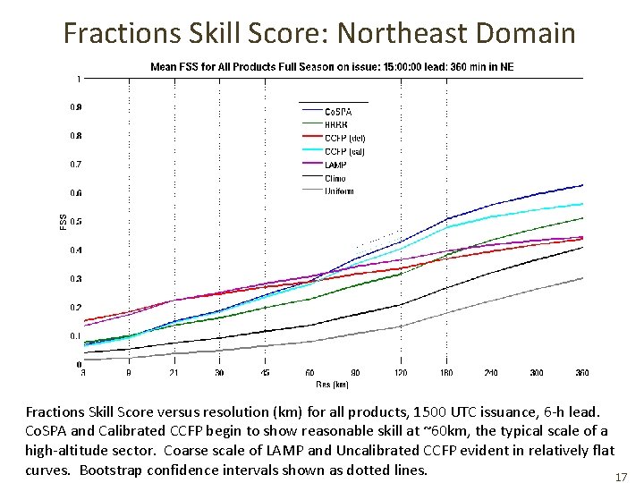
Fractions Skill Score: Northeast Domain Fractions Skill Score versus resolution (km) for all products, 1500 UTC issuance, 6 -h lead. Co. SPA and Calibrated CCFP begin to show reasonable skill at ~60 km, the typical scale of a high-altitude sector. Coarse scale of LAMP and Uncalibrated CCFP evident in relatively flat curves. Bootstrap confidence intervals shown as dotted lines. 17

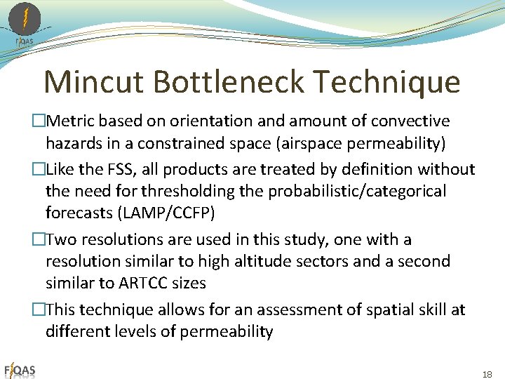
Mincut Bottleneck Technique �Metric based on orientation and amount of convective hazards in a constrained space (airspace permeability) �Like the FSS, all products are treated by definition without the need for thresholding the probabilistic/categorical forecasts (LAMP/CCFP) �Two resolutions are used in this study, one with a resolution similar to high altitude sectors and a second similar to ARTCC sizes �This technique allows for an assessment of spatial skill at different levels of permeability 18

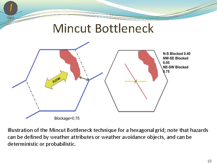
Mincut Bottleneck Illustration of the Mincut Bottleneck technique for a hexagonal grid; note that hazards can be defined by weather attributes or weather avoidance objects, and can be deterministic or probabilistic. 19

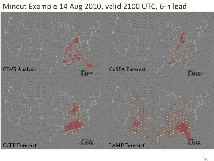
Mincut Example 14 Aug 2010, valid 2100 UTC, 6 -h lead CIWS Analysis Co. SPA Forecast CCFP Forecast LAMP Forecast 20

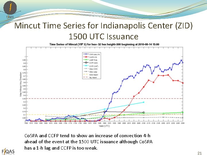
Mincut Time Series for Indianapolis Center (ZID) 1500 UTC Issuance Co. SPA and CCFP tend to show an increase of convection 4 -h ahead of the event at the 1500 UTC issuance although Co. SPA has a 1 -h lag and CCFP is too weak. 21

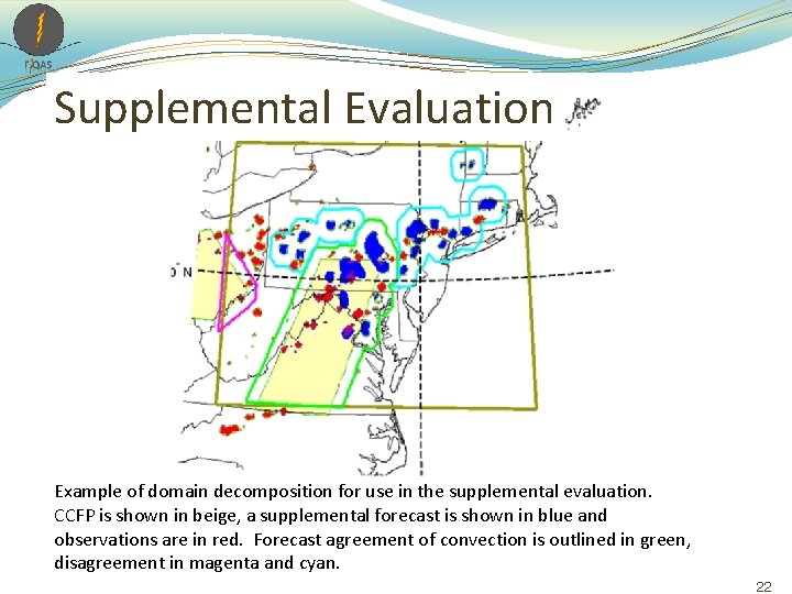
Supplemental Evaluation Example of domain decomposition for use in the supplemental evaluation. CCFP is shown in beige, a supplemental forecast is shown in blue and observations are in red. Forecast agreement of convection is outlined in green, disagreement in magenta and cyan. 22

Co. SPA as a Supplement to CCFP Findings �Co. SPA performs better when co-located with a CCFP polygon (agreement) than when outside a CCFP polygon (disagreement). �When Co. SPA forecasts significant areal coverage of convection inside a CCFP sparse coverage/low confidence polygon (typically ignored by the user) Co. SPA tends to verify and does so better than LAMP. 23

NOAA/ESRL/GSD 24

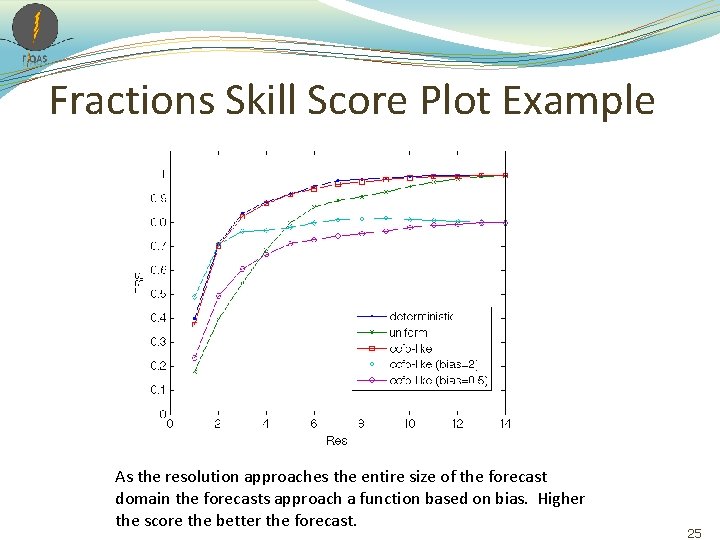
Fractions Skill Score Plot Example As the resolution approaches the entire size of the forecast domain the forecasts approach a function based on bias. Higher the score the better the forecast. 25

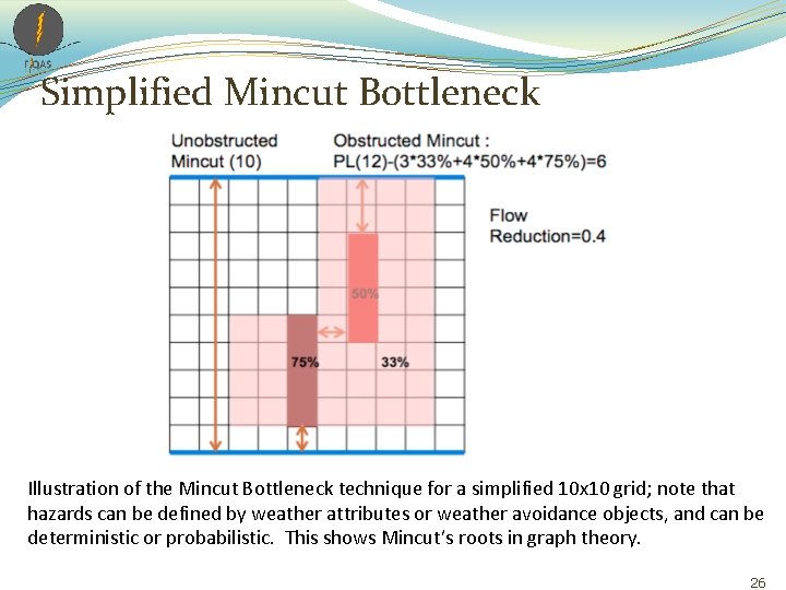
Simplified Mincut Bottleneck Illustration of the Mincut Bottleneck technique for a simplified 10 x 10 grid; note that hazards can be defined by weather attributes or weather avoidance objects, and can be deterministic or probabilistic. This shows Mincut’s roots in graph theory. 26