Introduction to Oceanography Layers of the Earth Layers


 • Magma is formed here • Magma Convection currents")


 Spreading Centers(Divergent) b)")

 Plate Tectonics - evidence for theory of")


 Divergent- Spreading centers - ‘rift zones’ Process: 1) Convection cells form")
 a) Spreading centers - ‘rift zones’ (cont’d. ) 5) Faulting")
 a) Spreading centers - ‘rift zones’ (cont’d. ) • Plates")
 (cont’d. ) Convergent- Subduction zones • Lithospheric Plates collide - ‘convergent’")
 b) Subduction zones (cont’d. ) 3 types of subduction zones:")
 b) Subduction zones (cont’d. ) 2. Ocean lithosphere into ocean")
 b) Subduction zones (cont’d. ) 3. Continental lithosphere into continental")
 c) Transform faults • Plates slide past one another •")
")

 • Magnetic anomalies in ocean crust. . . look at")

")
 Hot spots ~ Hawaiian Islands ~ islands or sea mountains")


- Slides: 47
Introduction to Oceanography
Layers of the Earth
Layers 1. Crust 2. Mantle 3. Core 1. 2. 3. 4. 5. Crust Asthenosphere Mesosphere Outer Core Inner Core
Crust • 2 types 1. Continental- 30 -70 km thick 2. Oceanic- 8 km thick
Lithosphere - Crust and Upper Mantle - Made of 7 major plates - Solid
Asthenosphere • Semi solid (Plastic) • Magma is formed here • Magma Convection currents • Lithosphere (plates) move on top of asthenosphere
Mesosphere • Solid because of high temperature and pressure
Outer Core • Nickel and Iron • Liquid • Spins around inner core • Causes the Earth’s Magnetic Field • Very dense
Inner Core • Nickel and Iron • Solid • Extreme high temperatures and pressurecompacts molecules=solid
Plate Movement- Past, Present and Future
Plate Tectonics 1. Theory of Plate Tectonics 2. Plate Boundaries a) Spreading Centers(Divergent) b) Subduction Zones(Convergent) c) Sliding Faults (Transform) 3. Plate Movement
The Theory of Plate Tectonics “Continental Drift” - theory* proposed by Alfred Wagner, a German meteorologist (1915) Explained by: • geologic fit • fossils * Not accepted by scientific community - no mechanism to explain plate movement
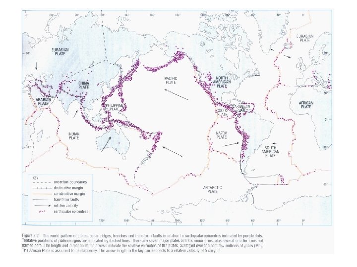
The Theory of Plate Tectonics (cont’d. ) Plate Tectonics - evidence for theory of continental drift Found 3 types lithospheres plate boundaries, 1) ridges (spreading centers) Divergent 2) trenches (subduction zones) Convergent 3) transform faults (plates sliding past one another)
Constructive Margin Mid-Ocean Ridge Destructive Margin Subduction Zones Constructive Margin Transform
Conservative Margins-Transform Faults
3 -3 Destructive margins Subduction zones Constructive margins Midocean ridges Driving Mechanisms for Plate Motions
Plate Boundaries a) Divergent- Spreading centers - ‘rift zones’ Process: 1) Convection cells form • Density differences – cool vs. hot 2) Convection cells cause frictional drag on lithosphere 3) Lithospheric crust weakens
Plate Boundaries (cont’d. ) a) Spreading centers - ‘rift zones’ (cont’d. ) 5) Faulting – break in overlying lithosphere 6) Magma flows upward 7) New lithospheric crust formed
Plate Boundaries (cont’d. ) a) Spreading centers - ‘rift zones’ (cont’d. ) • Plates split apart -‘divergent plate’ boundary • New crust formed ‘constructive’ plate boundary • Convection Video
Plate Boundaries b) (cont’d. ) Convergent- Subduction zones • Lithospheric Plates collide - ‘convergent’ plate boundary • Crust destroyed - ‘destructive’ plate boundary • Forms trenches and mountains
Plate Boundaries (cont’d. ) b) Subduction zones (cont’d. ) 3 types of subduction zones: 1. Ocean lithosphere into continental lithosphere – form trenches and mountain ranges Ex. a): Cascade Mtn. Range Ex. b): Andes Mtn. Range
Plate Boundaries (cont’d. ) b) Subduction zones (cont’d. ) 2. Ocean lithosphere into ocean lithosphere – forms trenches and island arcs Ex. A): Aleutian Islands (Alaska) Ex. B) Isthmus of Panama
Plate Boundaries (cont’d. ) b) Subduction zones (cont’d. ) 3. Continental lithosphere into continental lithosphere – form mountain ranges Ex. A) Himalayas
Plate Boundaries (cont’d. ) c) Transform faults • Plates slide past one another • Lithospheric crust neither created nor destroyed - ‘conservative’ plate boundary Ex. A) San Andreas Fault
Plate Boundaries (cont’d. )
Plate Movement • New crust is created at spreading centers at a rate of approximately 1 -10 cm per year • Old crust is destroyed at the same rate at subduction zones
Plate Movement (cont’d. ) • Magnetic anomalies in ocean crust. . . look at spreading centers ~ paleomagnetism ~ every so often Earth’s magnetic field flips (every 300 K-500 K years) ~ magnetic signal recorded in crust at spreading center as it’s formed
More evidence of plate moving. .
Plate Boundaries (cont’d. )
Plate Movement (cont’d. ) Hot spots ~ Hawaiian Islands ~ islands or sea mountains formed over hotspots (fixed area where magma comes up) ~ lithosphere moves over hotspot ~ volcanic mountain over hotspot and in ‘front’ of hotspot
Hot Spots?
3 -3 Mantle plumes • deep in the asthenosphere as molten rock which rises and melts through the lithospheric plate forming a large volcanic mass at a “hot spot”.
Age of Ocean Crust http: //www. ngdc. noaa. gov/mgg/geology. html
Geological Periods
Geological Periods Precambrian Cambrian Ordovician Silurian Devonian Early Carboniferous Late Carboniferous Permian Triassic Jurassic Late Jurassic Cretaceous K/T extinction Eocene Miocene Modern Future World Future 4. 6 B 514 Ma 458 Ma 425 Ma 390 Ma 356 Ma 306 Ma 255 Ma 237 Ma 195 Ma 152 Ma 94 Ma 66 Ma 50. 2 Ma 14 Ma 570 Ma solidification Gondwana, hard shell anim. separation, coldest Laurentia collides with Baltica pre-Pangea, equatorial forests western Pangea is complete deserts, reptiles, major ext. Life begins to rediversify, Pangea Dinosaurs, Pangea starts to break Pangea rifts apart, Atlantic New oceans, India end of dinosaurs India collides with Asia Modern look +50 Ma N. Atlantic widen +100 Ma new subduction +250 Ma new Pangea
Precambrian break-up of the supercontinent, Rodinia, which formed 1100 million years ago. The Late Precambrian was an "Ice House" World. Source: www. scotese. com Cambrian Animals with hard-shells appeared in great numbers for the first time during the Cambrian. The continents were flooded by shallow seas. The supercontinent of Gondwana had just formed and was located near the South Pole.
Ordovician The end of the Ordovician was one of the coldest times in Earth history. Ice covered much of the southern region of Gondwana. Silurian Coral reefs expand land plants begin to colonize the barren continents.
Devonian By the Devonian the early Paleozoic oceans were closing, forming a "pre. Pangea". Freshwater fish were able to migrate from the southern hemisphere continents to North America and Europe. Forests grew for the first time in the equatorial regions of Artic Canada. Early Carboniferous During the Early Carboniferous the Paleozoic oceans between Euramerica and Gondwana began to close, forming the Appalachian and Variscan mountains. An ice cap grew at the South Pole as fourlegged vertebrates evolved in the coal swamps near the Equator.
Late Carboniferous By the Late Carboniferous the continents that make up modern North America and Europe had collided with the southern continents of Gondwana to form the western half of Pangea. Ice covered much of the southern hemisphere and vast coal swamps formed along the equator. Permian Vast deserts covered western Pangea during the Permian as reptiles spread across the face of the supercontinent.
Triassic The supercontinent of Pangea, mostly assembled by the Triassic, allowed land animals to migrate from the South Pole to the North Pole; and warm-water faunas spread across Tethys. The first mammals and dinosaurs appeared; Jurassic By the Early Jurassic, southcentral Asia had assembled. A wide Tethys ocean separated the northern continents from Gondwana. Subduction zone Rocky Mountains
Formation of the Rocky Mountains http: //wrgis. wr. usgs. gov/docs/parks/province/rockymtn. html
Late Jurassic In the Late Jurassic the Central Atlantic Ocean was a narrow ocean separating Africa from eastern North America. Cretaceous Notice that North America was connected to Europe, and that Australia was still joined to Antarctica.
K/T extinction The bull's eye marks the location of impact site of a 10 mile wide comet caused global climate changes that killed the dinosaurs and many other forms of life. By the Late Cretaceous the oceans had widened, and India approached the southern margin of Asia. Eocene 50 - 55 million years ago India began to collide with Asia forming the Tibetan plateau and Himalayas (destroying the last of Tethys ocean). Australia, which was attached to Antarctica, began to move rapidly northward.
Miocene 20 million years ago, Antarctica was covered by ice and the northern continents were cooling rapidly. The world has taken on a "modern" look, but notice that Florida and parts of Asia were flooded by the sea. Arabia moved away from Africa forming Gulf of Aden and Red Sea; Last Ice Age When the Earth is in its "Ice House" climate mode, there is ice at the poles. The polar ice sheet expands and contacts because of variations in the Earth's orbit (Milankovitch cycles). The last expansion of the polar ice sheets took place about 18, 000 years ago.
Modern World If we continue present-day plate motions the Atlantic will widen, Africa will collide with Europe closing the Mediterranean, Australia will collide with S. E. Asia, and California will slide northward up the coast to Alaska.
Future +100 Earth is ~ 4. 6 bill years old – suggested cyclic of 500 mill year pattern of assembling and disassembling the land masses; Future +250